NEW - download 'Seoul VillageS (서울 마을들)', my collection of 12 short fictions now adapted into short films! Get your free copy of the ebook (4 editions: English, French, Korean, Bilingual English-Korean)!

Showing posts with label Goyang. Show all posts

Friday, January 12, 2024

Seoul Smart Life Week - What happens in Vegas stays in Seoul?

So taking more space at CES was not enough: Seoul wants to be a match with the World's leading consumer electronics show and launch 'Seoul Smart Life Week' later this year (Oct 7-9 in COEX).

Mayor OH Se-hoon announced the event at the 640 sqm Seoul Pavilion in Tech West Eureka Park, where 81 companies exhibited their solutions and gizmos (very strong biotech and A.I. verticals behind  Seoul Biohub and Seoul AI Hub). 18 of them claimed a CES Award, but the prize OH and Seoul Business Agency are after means even bigger bucks.

Well the first edition 'only' aims at 100 cities and 200,000 visitors, but it takes time to install a big show in a crowded calendar, and COEX can't host a Barnum the size of CES.

KINTEX would gladly oblige, but Korea's biggest exhibition venue is in Ilsan, Goyang, Gyeonggi-do, with limited hospitality capacity nearby. Seoul wants to become a global or at least an Asian leader, to put for good Tokyo, Hong Kong (and its half-yearly Electronics Fair), or Singapore (COMEX- ITSHOW-The Tech Show-Consumer Electronics Exhibition) behind. 

Seoul plans to change venues after the Jamsil Sports Complex is fully transformed into the Jamsil Sports MICE Complex, with a business hub connecting the COEX, SETEC, Hyundai Motors Global Business Center, Dominique Perrault's new Yeongdong-daero, and of course the Han River in this very vegassy vision mentioned in my recent focus (see 'Seoul waterways and urbanism - the full story'):

Seoul already hosts many tech-related events, but no top-of-mind brand emerges. At least, if it may not seem very original, 'smart life' sounds definitely more human-oriented than the old-tech-y 'electronics' or 'IT'. Unlike CES with the CTA, this new SSLW will not be led by an industry but by a local authority, with city pavilions rather than national spaces. To compete with Vegas, Seoul will not only need new hardware and software, but also the power hitters Korea Inc. sends to the national pavilion. And ultimately, Samsung LG, and Co. will have to be convinced to release buzzworthy novelties 3 months earlier than usual.


Seoul Village 2024
Welcome to our Korean Errlines! Follow Seoul Village on Facebook and Twitter, follow me on Instagram.
Download 'Seoul VillageS', the free ebook (12 short stories now adapted into movies).
Bookmark and Share

Sunday, December 26, 2021

7 Seoul subway / railway updates

MK published yesterday an interesting article* on the impact of 7 recent or upcoming subway / railway developments on real estate, which allows us to see of these old friends have fared since their announcements**.
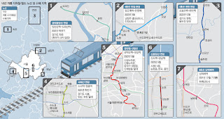
The Maeil Kyeongje's 7 projects (NB our focus below doesn't follow these numbers)

 . Line 1 extension Northwards from Soyosan Station (3 new stations - Choseong-ri, Jeongok, and Yeoncheon): 

Since this extension mostly doubles an existing train, the article logically mentions a low impact on real estate. but it does make commuting more seamless for densely inhabited parts of Yeoncheon-gun, and allows Seoulites to venture further up the Dongducheon valley (not necessarily closer to the DMZ, though: it follows the same axis in this area).

 . Line 4 extension Eastwards from Danggogae Station (3 new stations - Byeollae Byeolgaram, Onam, and Jinjeop):

To be inaugurated next March, this 14.9 km extension is a game changer for this section of Namyangju dotted with major new towns (Byeollae and Jinjeop-eup). But as usual, what a shame that such major clusters were not connected to the grid from day one. 

Of course, this means more commuter traffic for a line already supporting older generation bed towns, but it will also help one of them, Nowon, grow as a cultural hub in Northeast Seoul. Furthermore, the article reminds us of two other projects that will help cope with the flow:

  • Seoul considers doubling Line 4 with an express service for the 31.7 km section within city limits, between Danggogae and Namtaeryeong, with potentially 12 more stations concerned (all the ones connected to other lines). That would leave 12 stations with only the standard service, along with the ones in Gyeonggi-do.
  • The extension of Line 8 Northwards from Amsa Station to Byeollae Station (Gyeongchun Line) by the end of 2023 could later be prolonged to Byeollae Byeolgaram Station via a new station, Byeollae Jungang, further anchoring Byeollae to the South, and making it a transport hub east of Seoul around a decent 'Byeollae Line' backbone.

 . Inauguration of Namwirye Station (Line 8):

Located between Bokjeong and Sanseong Stations in Seongnam, Namwirye doesn't really support Wirye New Town which, as the author mentions, would have much more impact. But he's not taking into account a tramway bound to deliver the goods: the construction of the Wirye Line is just starting these days.

'#Seoul about to start the construction of its first #tramway in decades (#WiryeLine - 12 stations, 5.4 km - to open i 2025). Line announced 8 years ago (http://seoulvillage.blogspot.com/2013/08/seoul-lrt-projects-update-part-22.html) #transports' (20211220 - @theseoulvillage)


 . Gyeongui Jungang Line extension Northeastwards from Imjingang Station to Dorasan Station

In this part of Paju, as the article confirms, 'nothing to do with real estate'. This line is simply inching further towards Kaesong, now a reasonable walk away... provided of course you've got all the papers to enter the DMZ at that most strategic point. For the moment, you're mostly connecting Seoul to a giant, empty parking lot: doesn't look like many workers will commute any time soon to the Kaesong Industrial Complex... Let's hope that some day, this dead end will be prolonged into a friendlier North Korea.


 . Seohae Line extension Northwards from Sosa Station to Wonjong Station (via Bucheon Stadium Station)

As we've already seen (in "Twice upon a time in the West"), there's a lot going on around Bucheon. This vertical will split much earlier the traffic to/from Seoul between the North (Line 1) and the South (Line 7). And it will later be prolonged not only to Gimpo Airport, but also across the river, to Line 3 (Daegok Station, after a stop in Neunggok Station).

If Daegok seems a bit isolated between Goyang's 'old and new' New Towns (Ilsan to the West, Hwajeong to the East), Line 3 leads to more glamorous sites: downtown Seoul and Gangnam. And I wouldn't be surprised to see this new, vertical airport line that will go from Goyang to Hwaseong (for now, Ansan remains the Southern limit) venture further to the North-Northeast and connect to more New Towns.


 . Sillim Line inauguration (from Gwanaksan Station to Saetgang Station)

Thanks to this precious new vertical connected to Line 9 (Saetbang), Line 1 (Daebang), Line 7 (Boramae), Line 2 (Sillim), 'I live in Bongcheon-dong' will sound a lot more uplifting. But in parallel to this LRT,  Western Seoul needs more verticals (Gangnam-gu already getting it's fourth!), starting with Seobu Line...


 . Shinbundang Line Northwards extension from Gangnam Station to Sinsa Station:  

The article made its headline on the star extension because it's about real estate and money, and we're talking expensive real estate (Gangnam-daero), and expensive stations: Gangnam on Line 2, Sinnonhyeon on Line 9, Nonhyeon on Line 7, and Sinsa-dong on Line 3. No new stations, but hopefully fewer cars on the Hannam Bridge once Sinbundang's next profitable extension to the North will lead across the river and Yongsan, all the way to Yongsan Station.

*

Beyond railway and subway projects, Maeil Kyeongje also mentioned work on more sections of the capital region's Second Ring Expressway, which will definitely have some impact. But what the region needs is more public transportation, and a better dialog within Gyeonggi-do, beyond the usual Seoul-suburbs dialog.

It's always good to connect existing dots, and the Ansan-Bucheon-Goyang axis is very welcome, but no new major urban projects should be allowed without a direct connection to the network.

The problem is that Gyeonggi-do is poorly managed, and this has something to do with the way big cities compete with each other without a real regional authority. Only the State has the potential to force some collaboration, or at least more coopetition and less competition within Gyeonggi-do. The lack of political will and strategic vision results in the multiplication of projects cannibalizing each other, a suicidal rat race as the population ages and declines. Clearly, there are countless ways of spending less, better, and still generating much more value for everyone.

 
Seoul Village 2021
Welcome to our Korean Errlines! Follow Seoul Village on Facebook and Twitter, follow me on Instagram.
Download 'Seoul VillageS', the free ebook.
Bookmark and Share

* ""딱 역 3개인데, 폭발력 엄청나다"…판교 분당 부동산 난리난 이유" (Maeil Business Newspaper 20211226)
** see "Seoul subway to gain 89 km by 2025" (June 2015), "Seoul LRT Projects Update (Part 1/2)" and "Seoul LRT Projects Update (Part 2/2)" (August 2013, following "If you ain't broke, fix it: Seoul, Welfare and Railways Deficits" - July 2013). See also all subway related posts.

Monday, May 6, 2019

Twice upon a time in the West

The Minister of Land, Transport and Tourism came up with a new batch of developments for the capital region*, including new public transport projects, and unfortunately more instances of Korea's failed 'New Town' model, at the very moment the country experiences a slump in housing prices, and an oversupply of dwellings. The aim is actually to make sure the prices remain low for a while, which doesn't seem a bad idea, except that in Korea's speculative zero sum game, this necessarily means more losers, and more dead neighborhoods in the short, medium, and long term.

2 'New Towns', 26 small-to-medium-sized developments, 1 BRT, 1 subway line:

Following the first three announced last year (Incheon Gyeyang, Namyangju Wangsuk, Hanam Gyosan - in blue on the map below, which also shows future GTX lines), two more 'Greenfield New Towns'** will be created one kilometer West of Seoul, one on each side of the Han River (in red):
  • Goyang Changneung: 38,000 households in Deokyang-gu, Goyang (Yongdu-dong, Hwajeon-dong)
  • Bucheon Daejang: 20,000 households in Ojeong-gu, Bucheon (Daejang-dong, Wonjong-dong)

In a more acupunctural approach, 26 small and medium-sized residential projects shall add 51,517 households in already developed neighborhoods:


Transports-wise, the government's package proposes two new public transport lines, and road extensions:
  • a 17.3 km-long "S-BRT" line (NB does 'Super - Bus Rapid Transit' mean super dedicated infrastructures for buses?) between Gimpo Airport Station and Bucheon Sports Complex Station, around Gimpo Airport, with connections to subway lines 5, 9, and even 7 (Bucheon Stadium Station). It will also reach Cheongna BRT.
  • a new subway line will connect Goyang City Hall to Saejeol Station (Line 6), and intersect with Line 3, GTX-A, and Gyeongui Line at Daegok Station.
  • A new motorway will connect Baekseok-dong (Ilsan) to the Seoul - Munsan expressway (Gogang, Seoun interchanges).
  • Susaek-ro (already hosting 3 of the new housing projects judging by the map), and Worldcup-ro shall gain layers to cope with a growing traffic towards downtown Seoul as well as towards Yeouido and Gangnam.
Bucheon's new S-BRT line around Gimpo Airport
Goyang's new subway line


The good, the bad, and the ugly:


Overall, if you consider the three announcements made since last December, the State plans to sell 73,000 homes by 2022, 67,000 in 2023, 58,000 in 2024, 61,000 in 2025, and 44,000 in 2026, which may provide more options for affordable housing, but also amplify Korea's oversupply of dwellings. The only clear winner seems to be IKEA Goyang, today an outpost, but tomorrow ideally located to serve the new town.

At least, for a change,...:
  • ... Seoul intra-muros is spared from more of the large-scale New Towns that destroyed so many of its neighborhoods (including the seven buried under Gyonam New Town). 
  • ... a 'Greenfield New Town'** adds some urban continuity instead of pushing urban sprawl further afield: on paper, Goyang Changneung shall better tie Ilsan to the capital.
  • ... transports, including public ones, are better phased and synced with new major developments (new subway, BRT, GTX lines around Goyang and Bucheon new towns, respectively top and bottom):


This remains an absurd case where we add commuting traffic before solving existing problems upstream and downstream. Yes, commuters from the latest new town will reach Seoul faster, but they will slow down commuters from Ilsan's 'older new town', and more cars will flock into Seoul's Western bottlenecks, even if some cosmetic touches are added along Susaek-ro. Urban planners went as far in the irony as to name their concrete monstruosity after the Joseon Royal Tomb*** it will deface.

In this young millenium, any new project should aim at the very least at zero emission and zero increase in car traffic, and this is obviously not the case. I nonetheless appreciate the new public transport lines: the BRT will add some verticality and fluidity across Bucheon, and Goyang will better split its commuters between line 3 and 6.

All this also means that the construction of Seobu Line / Seobuseon becomes even more urgent (see "Seobu Line confirmed as Seoul's LRT top priority"). Just months ago, the project was delayed because SNU wanted to prolong the line further into its campus, and now a boost comes from the other end of the line, the national government speeding up the agenda, and footing the bill for the first 7 stations. Because actually, this new Goyang line constitutes the new beginning of the most defining project for the Western half of Seoul's subway network. Now hopefully, the whole line should be completed by 2026.

On the other side of the Han River, Bucheon will clearly benefit from a denser public transportation network. How the new town will coopete with Magok District or Gyeyang Techno Valley remains to be seen....


Seoul Village 2019
Welcome to our Korean Errlines! Follow Seoul Village on Facebook and Twitter, follow me on Instagram.
Bookmark and Share
Add this page to your favorites

* see for instance in Today's Chosun Ilbo: "3기신도시 고양 창릉·부천 대장동 등에 11만가구 공급", "새절역~고양시청 철도, 김포공항역~부천종합운동장역 BRT 신설", or in Today's Joongang Ilbo: "집값 다시 뛸라...집값 약세 둔화에 3기 신도시 '기습 발표'" (UPDATE 20190508 "To cool real estate, gov’t plans two new towns")
** as defined in "Wet eyes for wetlands and urban mirages"
*** see "Royal Joseon Tombs Become UNESCO World Heritage Properties
**** and by the way, these latest developments make even more irrelevant the Gangbuk Line project drafted a couple of months ago - see "Gangbuk LRT - Naebu v. Seobu, or PARK v. OH?")

Thursday, August 1, 2013

If you ain't broke, fix it: Seoul, Welfare and Railways Deficits

I wanted to say a thing or two* about welfare and railway projects in Seoul following these two articles in Monday's Korea Herald:

  • In "[Editorial] Seoul’s rail project" (subtitled "Debacles in other cities should serve as lesson"), the editors accuse PARK Won-soon of pushing a pharaonic and ill-financed program of 10 new light railway lines in the capital (including new tributaries to the ones listed earlier this month, see "Seoul Light Rapid Transit Back On Tracks"), which would cost KRW 3.5 tn to a city already KRW 26 tn in the red (the government would foot 1.1 tn of the bill, leaving 3.9 tn to private investors), not counting yearly compensations for the operators. The Seoul Mayor is also suspected of outrageously flip-flopping on the issue in order to boost his ratings ahead of next year's elections: he cancelled 6 of the 7 lines initiated by his predecessor OH Se-hoon, and now he's pushing even further.

  • In "Seoul City may halt free child care", we learn how Seoul Metropolitan City criticizes PARK Geun-hye's government for promoting a non-sustainable free child care program for all kids under 5. PARK Won-soon asks the government to raise its subsidies from 20 to 40% because unlike more demographically challenged regions, his financially challenged city has to cope with 408,000 of these little citizens. If he mentions the fact that 42% of them are raised in wealthy households (top 30% bracket), PARK Won-soon doesn't go all the way and say that 42% of these kids may not necessarily need a $180 check every month, because he himself was elected on a non-sustainable free meal program that contributes to the said deficit (reminder: ironically, OH Se-hoon was the one proposing the "leftist" model where the rich would pay for the poor - see "Welfare in Korea: the debate (or lack of)" 2012 and "Seoul free school lunch referendum (continued)" 2011).

But there's an awful lot to say about Seoul's new railway projects. We're Thursday and, as I just wrote this morning*, I haven't finished yet. So I'll post today the part about the big picture, and the one about the 10 Light Rail Transit projects will follow as soon as I can.

But first, my two cents about welfare.


*

1) On welfare:


Of course, that's just politics as usual. The Saenuri Party wants to claim back Seoul, and this free child care for all almost sounds like an ironic joke ("so you fancy universal freebies, uh?") at the expense of a man who could also become a serious menace for the 2017 presidential elections: elected as an independent, PARK Won-soon is now running for the DP, and leveraging Korea's most powerful local authority to multiply popular/populist initiatives, leaving his only potential rival to date AHN Cheol-soo very much isolated, with little political machinery around him, and little media coverage.

I already made my point about welfare state, the state of welfare, and the state of the debate on welfare in Korea. Again, PARK Won-soon must give up ideology and populism, embrace pragmatism, and among other things stop offering free meals to the wealthiest. And again, Saenuri and the governement must also give up their own ideology, populism and pharaonic pork-barrel projects, and among other things promote a sound and sustainable welfare system, and carry out the structural reforms needed to revive Korean demography (including in the education system...).

Unfortunately, reason remains most of the time a foreign word in Korean politics nowadays.

Significantly, in its revised Seoul Metropolitan Rapid Transit Master Plan**, the city is using the word "welfare" to qualify new railway projects. That's typical PARK Won-soon "human-centric-on-the-fringe-of-populism" lingua, but I do believe in public service, and in public transports as a fundamental right for metropolitan citizens. Besides, "welfare" and "fare well" are akin.

I'm not for or against anyone. I want Seoul, the region, and Korea as a whole to succeed and to invest wisely when it's still possible. And when I say "Korea as a whole", I mean both Koreas: the frontier is very close, and it won't remain closed forever.

At this moment, just like Korea has a welfare deficit, Seoul has a railway deficit, so if you ain't broke, fix it.


*


2) On the revised Seoul Metropolitan Rapid Transit Master Plan: yes, Seoul needs more railways...


10 years from now, all Seoulites shall live within a 10 min walk from a subway station. Or rather the overwhelming majority of Seoul citizens: the most remote parts of this mountainous city are not solely populated with Steve Austins, Jaime Sommerses, and other Usain Bolts.


The biggest gaping holes in the grid shall be significantly reduced (e.g. Seodaemun-gu, Geumcheon-gu, Northeast)

That's the ambitious target fixed in the revised Seoul Metropolitan Rapid Transit Master Plan** expected (in whose dreams?) to be validated next year by the Ministry of Land, Infrastructure and Transport. Seoul will officially submit the plan in September.

Compared to earlier versions, the vision has been a bit simplified at the macro level and complexified at the micro level. I'll get into the details for the suggested improvements to the "broadband" backbone and Light Rail Transit projects, but one thing is sure: Seoul does need more railways.

If I already questioned the economic viability of the new light rail lines, I disagree with those who think that buses will solve everything. Even if the Seoul bus network is very efficient, railways mean high capacity and consistency, and they represent the main backbone for any metropolis, a core element of multimodal transportation systems aiming at reducing the use of cars and promoting public services and greener individual modes (pedestrians, cyclists...).

Clearly, Seoul is still lagging behind key rival capitals. Subways carry only 36% of Seoul passengers (28% take buses / 31% cars or taxis / 5% other), compared to 86% in Tokyo (1 / 11 / 2%), 65% in London (8 / 25 / 2%), and 58% in Paris (9 / 28 / 5%).

By extending its rail network to 441 km, Seoul expects to raise the share of public transport from 64 to 75%. Today, its 327 km-long network is only 15% longer than that of Paris, a city six times smaller:


CityDaily users (M)Tot. rail netwk (km)Subway (km)Light Rail (km)Street-car (km)Mono-rail (km)Netwk per citizen (km / M)
LONDON3.2104644023428-67
PARIS4.180283218-65-43
TOKYO8.50035430616171840
SEOUL7.010327327---31


3) ... but the big picture could be improved


At the macro level, Seoul wants to beef up its "broadband" backbone, and to strengthten the 'Hanyang-Gangnam-Yeouido' triangle. "Hanyang", that's the original name of Seoul, a more poetic word than "downtown", and a wide area encompassing a significant number stations... except the one supposed to be Seoul's main hub: sorry, but Seoul Station is not located within fortress walls!

Anyway, here's the big picture:


This map shows us the three above mentioned hubs, and four colorful axes:

  • The blue axis refers to the future Sinansan Line (Seoul Station-Ansan Jungang): Phase 1 (Yeouido-Gwangmyeong) is expected by 2019, and the rest (Seoul Station-Yeouido + Gwangmyeong-Jungang) by 2022. Seoul city doesn't need to change the program.

  • The purple axis refers to the Sinbundang Line, which Seoul would like to extend all the way to the new Samsong District in Goyang via Gwanghwamun, a project that would also alleviate traffic congestion on Subway Line 3 and Tongil-ro. For the moment, only the Gangnam-Yongsan section of the extension is scheduled (Phase 3 - 2018, via Sinnonhyeon, Nonhyeon, Sinsa, Dongbinggo or Seobinggo, and Ichon). Where would they pass by after that? Seoul mentions a 19.7 km extension between Donbinggo and Samsong, and we've seen similar projects before (see for instance "3 subway lines projects revived ?", 2 years ago), but this time Pyeongchang-dong could be in the loop: both sides of Jahamun tunnel seem to be awarded a dot in the above "before-after" map, and the other day I saw banners urging local authorities to keep their promises and to deliver the long expected subway... Anyway, intense lobbying should rage everywhere and at all levels until the elections.

  • The pink axis refers to the Suseo High Speed Railway (Suseo-Dongtan KTX - see "New KTX vertical to Gangnam by 2015" - NB: Suseo also in a Korea Train eXpress project to Pyeongtaek). Seoul wants a 30.4 km-long extension between Suseo and Uijeongbu via Cheongnyangni to create a Dongtan-Uijeongbu line. Note that this pink axis doesn't pass by any of the three hubs, which proves that the presentation needs some fixing.

  • The green axis refers to the GTX Line B. Expected for September 2016, the Great Train eXpress project consists of 3 lines, each one about 45-50 km-long:
    - GTX Line A is in the general direction of the "purple axis" (Sinbundang): initially from KINTEX (Ilsan/Goyang) to Dongtan New Town (Hwaseong) via Daegok, Yeonsinnae, Seoul Station, Gangnam Station, and Suseo (NB: the Suseo-Dongtan part corresponds to the KTX, stretching the line to 74.8 km overall).
    GTX Line C is in the general direction of the "pink axis" (KTX): from Geumjeong to Uijeongbu via Gwacheon, Yangjae, Gangnam, Cheongnyangni, and Changdong/Sanggye.
    - Seoul city focuses on the GTX Line B, initially planned from Cheongnyangni to Songdo via Seoul Station, Yongsan, Yeouido, Sindorim, Dangarae, Bupyeong, and Incheon City Hall. But only the Songdo-Dangarae-or-Sindorim section seemed secured. Seoul suggests to change course, and to draw a southern express line across Seoul from Dangarae to Jamsil (30.3 km), via Gangnam of course. Note that GTX is not just 3 times faster than a standard subway, it also has fewer stations, which would shrink a trip from the COEX to Ilsan from 83 to 22 min in case of Line A, or a Songdo-Jamsil from 112 to 39 min according to this newly suggested route.

Frankly, I'd like to see a different presentation. If we want to improve the whole system, we need to understand the situation and the dynamics, the challenges. We need to see several maps of Seoul and its sudogweon region with all existing road and railway networks, all the projects already in the pipe, the ones already in discussion, but also the mountains and valleys, the demographics, the fluxes by transportation modes, the hubs and nodes, the bottlenecks of today and tomorrow (e.g. New Towns)... We need to visualize the present and the future.

Before getting the recos for the rapid transit, we want a big picture of the dynamics, regardless of the transportation networks that enable them. There are too few elements in the document released last month about transports (Vision 2030), and not many maps, let alone relevant ones. If the  previous administration can be blamed for many things, it was much better at communicating a strategic vision and at drawing maps, for instance in this slide from the 2006-2010 plan (Vision 2020):


Of course this map is debatable too. But here, we know much more what's going on, and what the city has in mind. We also know that before thinking Songdo, Dongtan or Uijeongbu, Seoul thinks - as it should - Incheon, Daejeon, Chuncheon, or Pyeongyang (talking about the big picture and tomorrow challenges!). Furthermore, we visualize a much more relevant selection of main hubs: we're neither forgetting Yongsan, nor neglecting the considerable effort around Sangam-Susaek and Cheongnyangni-Wangsimni to boost Northwest and Northwest Seoul and relieve downtown bottlenecks at the same time.

So back to the drawing board. And more maps, please. I love maps.


*

See also the following 2 focus on all LRT projects:
"Seoul LRT Projects Update (Part 1/2)"
(the full list of 7+3+3 projects, the "3-Tailed Dragon")
"Seoul LRT Projects Update (Part 2/2)"
(all other projects)


*


* Well, I already did that Monday on Twitter, but with a constraint of 2x140 characters:


@theseoulvillage tweets 20130729
wants fair free child care (same as what wanted for free meal program ^^!)
(9:55 PM - 29 Jul 13 - twitter.com/theseoulvillage/status/361832451628216321)
mayor also flip-flopping regarding 's railway projects, according to
(9:58 PM - 29 Jul 13 - twitter.com/theseoulvillage/status/361833197744562177)
 

*

Seoul Village 2013
Welcome to our Korean Errlines! Follow Seoul Village on Facebook and Twitter
Bookmark and Share
Add this page to your favorites

* if writing "Yonsei-ro the first street in Seoul to ban cars in its transportation mix" contributed to the delay, it also paved some of the way ahead
** see "'서울 어디서나 도시철도 10분' - 철도 중심시대가 열립니다" (seoul.go.kr 20130725)

Tuesday, June 18, 2013

Songdo, DMC: sequence is of the essence (Part II)

In the first part of my umpeenth focus on Songdo and the Seoul DMC ("Songdo, DMC: sequence is of the essence (Part I)"), I insisted on symbols, images, concepts, purpose. Here, I linger on space and time, key dimensions of urbanism and architecture, where consistencies or discrepancies resonate. Of course, urbanism and architecture are foremost about humans, and when that small detail is not at the center of preoccupations, it shows.

Part I covered sections 0 and 1 of the 'master plan' below, Part II delivers lot # 2 (see also links to related articles at the end of this post), Part III will focus on the importance of timing:

0) City, Interrupted. Puzzle, Ongoing. Landmarks and Landscars
1) Purpose and Identity, Citizens and Citizones, Projects and Projections
2) Connectivity, Continuity and Consistence
3) Longing and Belonging - Sequence is of the Essence
NB: again, Songdo and the DMC cannot be compared (e.g. scale, timelines, stakes, relative importance for local authorities...), and they don't compete directly. This is not a comparison but a parallel update, with random thoughts about the evolution of ambitious urban projects.

Stephane

UPDATE: see Part III
UPDATE: download the whole focus in PDF format here.

*

2) Connectivity, Continuity and Consistence

Once more, these "Ubiquitous" cities are not yet "All Over The Place", and work is still in progress, so be patient!


"Songdo Central Gap"
One of Songdo's "Central Gaps". This block will soon be filled with low rise commercial buildings and shops.


Seoul DMC's Blind Spot
One of the DMC's few remaining blind spots last year, along Digital Media street. This LED screen caught a bug, but the artwork is blind anyway.

But before exploring these new cityscapes, let's see how they integrate to their surroundings. If both Songdo and the DMC are connected to Incheon and Gimpo airports as well as to their respective urban environments, some key connectors show a bit too much, and seamlessness or urban continuum were not always top priorities.

For Songdo, that's almost a statement: "this is an exclusive neighborhood, let us grow on our own":
  • Like Incheon Airport and the Incheon Bridge, Songdo is a place where sea meets sky. Skyscrapers emerge from far away in a rather flat landscape, and the newly claimed land also stands out from the sky:


IFEZ view of Songdo
According to the IFEZ master plan, Songdo will reach for Ansan and Incheon's old harbor, while growing a new one. But the IBD has yet to fill all the parts where earthwork has already been completed.
  • Songdo IBD will eventually become a peninsula connected to Sinheung-dong to the north (when District 9 is completed), and firmly anchored to its surroundings through 6 bridges, not to mention of course the spectacular Incheon bridge, a direct link to Incheon Airport. On its northwestern side, it almost touches Dongchun-dong along Saeachim Park (New Morning Park), a promising promenade with a narrow waterway and two mini "mountain chains" in the background (Cheongryangsan-Munhaksan, Songdo's skyline).

  • Unfortunately, Songdo combines two sins commonly seen in Korean new towns: the Great Highway Rift, and the Elevated Highway Curse:

  • - Instead of camouflaging the beefed-up Aam-daero, open air lanes have been added to further separate Songdo from Dongchun-dong and the future Paramount Movie Park Korea. Even if bike lanes have been laid out, cars rule overwhelmingly.

    - Incheon Bridge ends in two concrete ribbons blotting out the scenery: Incheondaegyo Expressway (Highway 110) and Songdo Haeandoro (3rd Gyeongin Expressway along coastal road 77). The 2nd Seoul outer beltway will soon stretch new tentacles over the ocean, making sure the future Incheon New Port is itself cut from the rest of the IBD.

    - This at a time when Seoul bitterly regrets the concrete monsters that disfigure some of its cutest waterways. This at a time when Paris starts covering its belt highway "Peripherique" to improve the osmosis with its direct urban environment, and considers doing the same around its La Defense business district. This at a time when Seoul thinks of ways of hiding the expressways separating Han riversides from the rest of the city... Again, highways don't belong in sustainable cities, and elevated roads are supposed to be patches you use when urban planning failed, the worst possible solution when you start from scratch. New roads should alleviate traffic, not cause more problems and create more demand for cars.


Songdo - Los Angeles
From a distance, Songdo looks as highway-and-car-friendly as L.A.


Brughel meet Songdo
Songdo meet Brughel meet a great Korean classic: the elevated highway.


Songdo's 2nd Bridge
Songdo 2nd Bridge over Saechim Park, the Incheon Bridge expressway to the right
  • Note that subway-wise, the aerotropolis is directly connected to the old Incheon center, but not to the airports: the Incheon Bridge was not doubled with railways, and you have to reach the AREX at Gyeyang Station, at the other end of Incheon Subway Line 1. That's not a long trip, but you draw a "seven" 3 to 4 times longer than the Incheon Bridge's straight line. And if the Suin Line will complete the Suwon-Incheon loop by 2014 (joining Songdo Station to Incheon Station), Songdo IBD hangs by itself at the end of the Line 1 hook. More stations are planned, but for the next one we might have to wait for the Songdo Incheon Tower, and the construction of the business center on the other side of Canal Walk has been postponed.


Canal Walk on the wild side, sunset over Incheon Bridge


  • For the moment, Songdo has to do all the pushing, whereas it should be more a win-win, push-and-pull game with surrounding areas. Typically, the synergies between the IFEZ's 3 sub-projects (Yeongjong-Songdo-Cheongna) and the rest of Gyeonggi-do would be boosted if there were a coastal vertical connecting Cheongna, Incheon's Jung-gu, Songdo, and Siheung-Ansan. That's the role of the future 2nd Seoul outer beltway, but ideally, the vertical should also exist in a railway version. BTW I'm glad that they eventually decided to build a AREX Cheongna Station, but I still can't believe it was not planned from the start - as if the AREX and IFEZ projects existed in different galaxies! As a matter of law, I think no New Town project should get any authorization if there's not at least one subway connection from day one, and Subway Line 1 reached Songdo only in 2009, four years after the delivery of the first blocks (district 2).

The much smaller - and far closer to completion - DMC is now plugged as if to boost broadband communications within Western Seoul as well as between the capital and its neighbors. In spite of its own natural and man-made frontiers:
  • The DMC draws a "T" in the northern half of Sangam-dong, which itself a draws a trapezoid on the Han River. If this block can't be compared to an island or a peninsula like Sondgo, its borders are clearly marked for pedestrians:

    - To the South, the block is separated from the Han River and its riverside park (Nanji Park) by the Gangbyeon Expressway and its 10 lanes of traffic. Also known as Jayuro or "Freedom Expressway", Gangbyeon runs along the Han River all the way to Paju, and connects the capital to Gimpo and Incheon airports. Note that unlike Songdo, the DMC is directly connected via AREX to both airports. Actually, at one stage, the Seoul Lite landmark tower was by itself meant as an all inclusive, miniature aerotropolis for business travelers. It a good thing that this anti-city scenario was dropped.

    - To the North, a disgracious urban separator prevents the DMC from dialoguing with Susaek-dong and Eunpyeong-gu: the Gyeongui Line. Seoul city considers burying it, but it will take time and here, it's as wide as around Seoul Station. And it's doubled with yet another major entry point to Western Seoul: a 6-to-8-lane axis that goes straight from Gwanghwamun to the heart of Goyang and Ilsan, first as Sajik-ro, then as Songsan-ro, here as Susaek-ro, and through Gyeonggi-do as Jungang-ro. Overall, if you include the thin layer of buildings sandwiched between the railways and the road, that's a 300 m - wide band, almost as thick as the bar of the "T". The Digital Media City Station (AREX, Gyeongui Line, Subway Line 6) does connect both sides, but the whole area will boom the day a Gwangwhamun Square-like revolution helps pedestrians claim that bandwidth, critical for seamless communications.

    - To the West, the DMC/Sangam-dong block is separated from Daedok-dong, Goyang city by Gayang-daero / Deogun-ro (8 lanes). And to the East, Jeungsan-ro (8 lanes) and Bulgwangcheon stream (3 bridges) mark the frontier with Songsan-dong / Jung-dong, Mapo-gu.


The Seoul DMC T and Sangam-dong
The T-shaped DMC in the Sangam-dong trapezoid.

  • These vertical connectors (W/E) anchor the whole neighborhood to Western Seoul's two main entry points by road: Gangbyeon Expwy and Susaek-ro (S/N). They also reach across the river: Gayang-daero leads to Gayang-dong, Gangseo-gu, via the Gayang Bridge, and Jeungsan-ro will be prolonged southwards by the World Cup Bridge to Yeongdeungpo-gu (see "A World Cup Bridge for 2015"). Doubled with the Subway Line 6 loop, Jeungsan-ro also links the DMZ to the northernmost parts of Seoul : Eungam, and beyond, Yeonsinnae, Eunpyeong New Town, or Tongil-ro. To reach the Gangnam half of Seoul by rail, you have to reach Subway Line 2, or use the AREX (the future Magok District will only be one station away when Magongnaru Station opens).
  • Overall, the DMC/Sangam block is rather well connected to the grid. But it's not just piggybacking an existing network: it also acts itself as a power plug connecting to Mapo-gu and Seoul parts of Gyeonggi-do previously underserved between the two horizontal backbones:

    - Eastwards, three 4-to-5-km-long "pins" of this plug reach deep into Mapo-gu: the three avenues that support the DMC's "T". At the top, the narrowest and shortest (Seongam-ro / Yeonnam-ro, 4 lanes) follows the lower Gyeongui Line until Donggyo-ro. That's the top of the bar. The other two go all the way to Yanghwa-ro: until Hongdae (Worldcup-bukro, 8 lanes), and Hapjeong (Nanjido-gil / Worldcup-ro, 6 lanes).

    - The "cable" end of the plug looks less subtle: blocked by Daedoksan to the West, the three roads merge through Daedok-dong into a road that crosses the southern parts of Goyang and Ilsan, and the western parts of Paju. Gorged with concrete steroids, this axis has become the second "Freedom Highway" (Je-2 Jayuro, #357), complete with brand new "unavoidable" elevated sections...
  • Mercifully, the DMC itself is spared the "Elevated Highway Curse"*. And also the sight, noise and traffic of the Gangbyeon Expressway, thanks to the World Cup Park and its twin hills (Noeul and Haneul). So the former Nanjido landfill**** was not only transformed into an ecopark, but also into a green wall protecting the whole rehabilitated neighborhood. Note that there are also two smaller green hills under the bar of the T (Sangamsan and Mebongsan gave their names to the two central vertical streets, Sangamsan-ro and Mebongsan-ro). So instead of a "T", you rather see from the sky a "M" drawn on a green trapezoid:


Aerial view of Seoul DMC
An 2012 areal view of the DMC (fished from InvestSeoul.com). In the bottom half of this picture, we clearly see from left to right Haneul Park, Mebongsan, Jeungsan-ro and its Jeungsan Tunnel, and the World Cup Stadium.

Now when I roam the streets of Songdo and the Seoul DMC during the day or at night, can I feel an urban continuum, a consistency with the original concepts? I'd say that in the DMC, I feel like in a modern Seoul business district among others, and in Songdo, supposedly the epitome of The City of The IIIrd Millenium, almost like in a tribute to the XXth Century:

  • Songdo is already alive and kicking. At the feet of most residential buildings, fleets of kid bikes tell the story of families enjoying fun time outdoors, and the city stretches only over 6 square kilometers at its core, so everything is within walking distance. The map can be easily memorized with its grid and functional blocks, and green areas cover a very significant proportion of the land. Smart details make life easier, for instance to cope with parcels when you're not home for the delivery, or to manage waste and energy... Citizens are confident that future commercial hubs (first around Lotte Mall, then North of Central Park) will boost the whole community.

  • But this dream city looks a bit too sanitized, the urban planners' storytelling too polished and far-reaching. Humans look a bit like extras on a giant stage where the roads are too wide, and the skyscrapers too tall, waiting for directions from above. Everywhere you can read the script for the land, but it's as if the actors expected a play to be written for them as well. I love to walk in cities but between these neverending blocks I feel frustrated. And why surelevate this park? Pedestrians can only see inside when there's an entrance, unlike in say Yeouido's central park, where the whole neighborhood can enjoy the show, not just those who are inside, or above, watching from their penthouses. There are buses on the streets, but very few bikes or taxis. I didn't expect Masdar City's Podcars, but at least a vision for the future, a comprehensive and innovative strategy for transportation. Overall, Songdo reminds me of urbanism from the 1950s, a "modern" vision of a functional American city where cars rule. There's even a Niemey'air of Brasilia - doesn't this Central Park's "Tri-bowl" echo Oscar's famous Congresso Nacional building? I remember being already disappointed by the master plan years ago, then when the first residential districts were delivered, in the mid-naughties. Only Canal Walk emerged as a potentially alleywayish element added to this very classic new town, but occupancy remains low due to delays in the developments around the structure.

  • More heterogeneous, the DMC mirrors the rest of Seoul. A significant part of Sangam-dong, in the Eastern half of the bar of the T, has not even been redevelopped. It includes the neighborhood's citizen center, and a few individual houses, but mostly consists of 3 to 5 story buildings. With Nuritkum Square at its crux, the Western half of the bar is marked by the curve of a "Digital Media Street" whose unfinished northern side has long been euphemized as an "art fence". This is certainly not a beautiful city or a model of urbanism, but it's somehow "softer", more convenient for pedestrians. Even if you have to cross a a wide road here or a railway there, the neighborhood is more at the human scale, the architecture less pretentious. Can it be fakely disruptive at times? Yes. Are we spared the usual "apateu" blocks? No. You're simply in a Seoul neighborhood with a decent green-to-concrete ratio, and an obvious 'business' purpose, not in some exclusive complex. After all, the DMC is not Sangam's only star: more Seoul citizens know the neighborhood for its World Cup Stadium, and many have if not visited at least seen the park and its wind power generators from the expressway.

Seoul city bikesharing station in the DMC
The DMC is one of Seoul city's two test areas for bikesharing services. Well located next to a bus station, this station is fully operational on this beautiful May 2012 day: 7 of the 10 bicycles are being used.


For the DMC as well as for Songdo, and regardless of the conceptual successes or failures, planners focused on sections of space. Timing and sequencing seems to have resulted from constraints rather than from a strategic vision of the city. But for cities, time is of the essence. And planners should make sure they've got the dynamics right from the start.

And for us, that will be the final part of this focus.

*

End of part II

See part I
See part III


*

See also posts related to Songdo and the DMC, in particular:
- "Songdo on the world map (Green Climate Fund)" (December 2012)
- "Wet eyes for wetlands and urban mirages" (January 2012)
- "DMC at full throttle - Songdo from Sim City to Sin City ?" (April 2011)
- "DMC aims at Tinseltown - welcome to Hallyuwood!" (February 2011)
- "Seoul Digital Media City Tour" (July 2010)
- ...

See also posts related to urbanism and new towns, including:
- "Sudogwon New Town Blues" (March 2013)
- "Magok District: SIM City as in "Seoul Intra Muros"? Alleyways as in "Seoul Inter Muros"?" (January 2013)
- "From urban mirages to urban decay" (November 2011)
- ...

Seoul Village 2013
Welcome to our Korean Errlines! Follow Seoul Village on Facebook and Twitter
Bookmark and Share
Add this page to your favorites

* even if the Naebu Expressway starts at its gate. It covers Hongjecheon (see "Along Hongjecheon, my way or the highway"), which Bulgwangcheon joins at the corner of Pyeonghwa Park, at Nongsusansijang-ro.

**** reminder: if Songdo was built from scratch, the DMC was partly built over trash.