NEW - download 'Seoul VillageS (서울 마을들)', my collection of 12 short fictions now adapted into short films! Get your free copy of the ebook (4 editions: English, French, Korean, Bilingual English-Korean)!

Showing posts with label Bukhansan. Show all posts

Friday, April 29, 2022

Seoul's Waterfront Renaissance

Seoul has always been defined by its most valuable environmental assets: its countless waterways, and the mountains that feed them. 

From the start, the capital revolved around Cheonggyecheon and its network of streamlets:
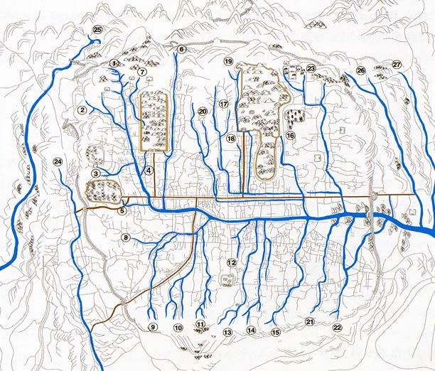
Nowadays, the Han River tells what's North and what's South, but waterways still account for 8.1% of Seoul's land (below in 2010):

After pouring concrete all over the place to tame the powerful Hangang and its tributaries, to stabilize unstable riverbanks, and to prevent recurring floods, the city has reopened its heart to its waterways, rediscovered them as leisure paths and environmental treasures. Following the restoration of Cheonggyecheon, the Hangang Renaissance, and the restoration of neighborhood streamlets, masses of humans, birds, and even fishes have flocked back to Seoul's watersides. Yes, more concrete was often poured in the process, but biomass keeps growing, embankments are often doubled with natural fish nurseries, and significant wetlands have been created.


Citizens are already very active along these waterways, thanks to all the infrastructure needed by strollers, cyclists, or workout maniacs:

But water level and street level are seldom seamlessly connected, and for good reasons: flash floods remain a constant threat, and these waterways help the city cope with extreme downpour. On such occasions, riversides must be evacuated immediately. Still, more citizens could spend more leisure time there, particularly when they crave for more free and cool open spaces.

More than a decade after his Hangang Renaissance project, Mayor OH Se-hoon aims at a 'Jicheon Renaissance' leveraging Seoul's 332 km of waterways. Not just with more hardware, but with more content and culture, a better connection to local neighborhoods and markets, More 'emotion', as part of an 'Emotional City' of the future vision.

Starting with 4 pilot projects along three streamlets (Dorimcheon, Jeongneungcheon, and Hongjecheon), with 2 more sites by 2030 (Anyangcheon and Jungnangcheon):

  • Hongjecheon will never fulfill its great potential as long as the Naebu Expressway disgraces it (see "Along Hongjecheon, my way or the highway"), and the pilot will focus on two spots: upstream at Hongjimun and Tangchundaeseong, midway at the artificial waterfall near Seodaemun District Office, with a place to have a drink.


  • Dorimcheon is more about the connection to the neighborhood and its businesses, with decks to make the transition and chill out:


  •  Jeongneungcheon will add a cultural layer through a new media art space:


Of course, all this requires water, particularly since the city intends to make these shallow streamlets a bit deeper (from a very thin 10 cm to a more significant 30 cm). So backstage, there's a lot of work to improve water and waste management. 

Today, 18 streamlets including Cheonggyecheon are actually fed with water recycled from the Han River, and climate change has spectacularly dried up the whole nation. Even if I knew Seoul experienced very few precipitations last Winter, I was stunned to see in a recent treck up Bukhansan, how parched soils were. But the only time water streamed by was magical:

As usual, I guess we'll have more imperfect, odd spaces requiring some improvement in further iterations. But overall, Seoul keeps democratizing access to quality time and nature, even if that's in not so natural spaces.

Seoul Village 2022
Welcome to our Korean Errlines! Follow Seoul Village on Facebook and Twitter, follow me on Instagram.
Download 'Seoul VillageS', the free ebook.
Bookmark and Share


Tuesday, August 5, 2014

Bukhansan Eunpyeong Hanok Maeul

Remember Eunpyeong New Town's Hanok Village? In case you missed that milestone project at the feet of Bukhansan and of the new town's towers, here are the main posts where they've been mentioned so far:
I'm inflicting you another update today because in this morning's mail, we received this leaflet for "Bukhansan Eunpyeong Hanok Maeul":


For this project, SH Corporation (Seoul public housing organization) must convince people who are interested in a different proposition, and won't fall with the classic hard selling techniques. Yet they're targeting first-time hanok buyers, not hanok ayatollahs (sorry to that loyal segment of Seoul Village readers; I don't mean to be mean, but you know what I mean!).

Note the absence of mention of the New Town in the branding, the green dominant, and the - relatively - high quality format. This leaflet has been printed on a much higher quality paper and in a more intimate size than the usual real estate ads.

Also significant marketing-wise, a specific 'hanok pedagogy' to lift worries commonly formulated by prospects: won't air conditioning be prohibitive? aren't hanok expensive to build? isn't their maintenance a constant headache? You can live in a hanok and enjoy modern comfort and community services.

On the site too, they did their best to differentiate the hanok village from the New Town:

- The expression 'model house' was replaced by a more respectful 'demonstrative hanok'...


- ... and traditional ceremonies were even performed for the show last year:


At least, as the construction continues, this part of the working site isn't a sea of cranes.

Seoul Village 2014
Welcome to our Korean Errlines! Follow Seoul Village on Facebook and Twitter
Bookmark and Share
Add this page to your favorites

Monday, November 18, 2013

No cablecars in Bukhansan, please

The old Eunpyeong New Town cable car project that raised many critics from environmentalists in the late noughties has been revived yesterday by Seoul Mayor Park Won-soon as a cheap quick fix for recurrent traffic jams between the new town and downtown*. Traffic jams that (sorry for repeating always the same things) should have been avoided in the first place, and public transit solutions considered as core elements of the said new town (an obviousness for any urban planner except - it seems - in this part of the world).

I can't deny the fact that cable cars are cheaper than, say, a railway extension such as the one the same Mayor promised last summer in his initial Seoul Metropolitan Rapid Transit Master Plan, a very ambitious wish list where the Sinbundang Line was supposed to be prolonged to Pyongchang-dong, the infinity and beyond (see "If you ain't broke, fix it: Seoul, Welfare and Railways Deficits). Cable cars are even cheaper than the already environment-unfriendly Eunpyeong-Seochon tunnel considered two years ago, a car-centric nonsense that triggered the following rant from this excuse for a blogger (see "2 more tunnels up North"):
"Eunpyeong-gu definitely needs more connections with the rest of the city, but the priority for a forward looking city should be to develop public transportation, and deter people from using their cars in already saturated areas. 
I mean come on : Seoul is digging tunnels #10 and #11, and not one of them has ever been for a subway or a railway! It's as if the mind frame was set on 1960s and 1970s instead of the new millenium: more people? build more roads, sell more cars! and don't bother with medium / long term consequences! 
This totally contradicts Seoul's efforts to develop tourism and international attractiveness: downtown is not supposed to become again an environmental nightmare and a communication failure."
But Seoul is not Santiago do Chile, where funicular railways made perfect sense to connect higher neighborhoods with the rest of the city. Here, cable cars would follow a roller coaster from ground level to ground level in an endless, preventable eyesore that would totally ruin Bukhansan (via Samgaksan, Bugaksan, Inwangsan), one of the capital's most valuable assets - not to mention, of course, Seoul fortress... and downtown Seoul as a whole, because this monster would go all the way from Gupabal Station to City Hall (either in a straight line of 9.6 km, or in a 11 km course that would pass over Tongil-ro via Yeonsinnae and Dongnimun)! All this to shrink to 20 mn a journey that takes 40-50 mn by car or 30-35 mn by subway!

And they have the gall to sell it as a potential tourist asset as great as the London Cable Car, an urban abomination only topped by the ArcelorMittal Orbit as the most embarrassing erection of the 2012 Olympics (in a city with a recent history already rich in urban disasters). 

Of course the view could be interesting from above, but that's what you'd see from under:

The Emirates Air Line, a.k.a. the London Cable Car, a low cost bridge over River Thames. Now picture that as you stroll around Sejongno, Seochon, or Jeong-dong... "touristic", isn't it?

Brits can do whatever they want over this part of the Thames, I won't let downtown Seoul welcome a new elevated wart, not even a decade after the restoration of Cheonggyecheon.

This project insults the city's past, present and future. Seoul can't fix Eunpyeong New Town's failure by making it even worse and more visible. 

So back to the drawing board, and I'm begging you, next time, please try to look for more sustainable ways.

Seoul Village 2013
Welcome to our Korean Errlines! Follow Seoul Village on Facebook and Twitter
Bookmark and Share
Add this page to your favorites

* see "서울시, 은평뉴타운~서울 도심 케이블카 건설 검토 논란" (Chosun Ilbo 20131118)

NO WAY! Park Won-soon considering cablecar connections between Eunpyeong new town and downtown Seoul! Save Bukhansan from this madness!
twitter.com/theseoulvillage/status/402245416474800128

Sunday, March 10, 2013

Build a hanok and they will come - Marketing impostures and genuine slow urbanism

Sorry for posting yet another focus on urban developments - following last Thurday's "Sudogwon New Town Blues" -, but even if you're not among the (more than a few) researchers and experts in urbanism who roam this excuse for a blog, this is about Seoul villages, old and new. Yeah, I also suffer from hypergraphia*, but that's not the issue.

Anyway. Korean "model houses" are always worth visiting for at least three reasons (see "Inhuman, all too human Seoul"): to follow housing market(ing) trends, to measure gaps between different levels of reality and their representations, and to explore ethnological goldmines. 

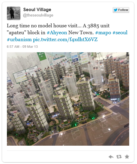
Yesterday, the piece de resistance was a rather classic project, this 3885-unit section of Ahyeon New Town:


see this Tweet on Tweeter

We'll get back to it later. Now check this medium-sized apartment block, also in Mapo-gu, and by the same developers, but this time solo (they partner with another chaebol on the previous project). As you can see, a brand new "hanok guest house" and its "hanok playground" sidekick are highlighted as star assets at the feet of the apartment towers, and in a pop-up that dwarves the rest of the mock-up:

see this Tweet on Tweeter
This "traditional" corner belongs to the condominium: all residents can enjoy the playground anytime, and a preferred rate when they want to rent the guest house, for instance when relatives visit for a special occasion.

If traditional pavillions or walls multiplied in the middle of new apartment complexes well before the real estate crisis**, the 'hanok fad' really caught in major commercial projects at the end of the naughties, from "hanok style interiors" to whole hanok complexes (see "New Towns : hanoks in Eunpyeong, a desert in Wangsimni", "Hanok New Town in Seongbuk-dong").

Most of the time, it's more a "Hanok Alibi": residents still opt for the usual "apateu" experience, and the traditional house only comes as a "feel good" factor, a marketing gimmick, like in a "Hanok Inside" campaign. Yes, we destroyed the old neighborhood but see, we respect traditional architecture. And if we can afford such a costly low rise construction on our very expensive land, it tells a lot about the value or our community and the values of its members. Anyway these days promoters seldom sell all apartments as easily as they used to, and for them cramming as many units as possible is not a winning proposition anymore...

On a more positive note, not so long ago, many prospects and customers would have been revolted by the idea of wasting money and space in this kind of old stuff. The fact that hanoks can "sell" confirms encouraging trends: at long last the general public is reconsidering Korea's architectural heritage, perceiving preservation efforts as positive (as long as they don't hinder your personal real estate projects, of course). And hanoks do sell: their market value has sharply risen in certain neighborhoods, where Seoul promotes and sponsors their creation and renovation.

At the individual level, building or restoring a hanok remains a statement, a long but rewarding process, and a perfect example of slow urbanism in a city where short term rules like a despot.

To a major development project, the "hanok touch" adds sense, anchors with the city's cultural continuum. But it works better when it's heartfelt, sincere, conceived from the start. 

As we saw, the hanok village was only a late addendum to Eunpyeong New Town, but without it, the project wouldn't be much distinguishable from any bedtown. And if it comes more as a transition to Bukhansan national park than to the cityscape, that's because the New Town is not contiguous with the rest of the district, except by the road and rail connections - mainly Tongil-ro, and Subway Line 3 between Yeonsinnae and Gupabal. Even if we are in Seoul, this is more a "greenfield new town", built in a valley of its own: the one carved by Changneungcheon, the stream that marks the Seoul-Goyang border in Jingwan-dong.

If I can't be satisfied with the destruction of part of Seoul's greenbelt for yet another real estate development, this looks much better than your usual tombstone "apateu" towers:

Eunpyeong New Town's hanok village: a new touristic entry point to Bukhansan... 

... but also a new neighborhood with over 200 private residences

Bonus: Eunpyeong Museum, yet another concrete dent into Seoul greenbelt (if you find it ugly, wait until you see the new Eunpyeong-gu office, on the other side of Tongil-ro)

If you prefer more intimate entry points to Bukhansan, you'll have to follow Bukhansan-ro further eastwards: not long after the T intersection with Yeonseo-ro, a streamlet will lead you up to the temple of Baekhwasa.

With its pedestrian highway of a paved road, this new gateway to the mountain is clearly meant for the masses. Environmentally debatable, Eunpyeong's hanok village shall become a touristic asset for the district and draw visitors from far away, among which some who would have never considered Bukhansan otherwise.

Hopefully, Eunpyeong new town shall not be just a residential dead end, or a bedtown lost in the outskirts, but a touristic destination, a neighborhood visitors will cross with a purpose, and - yes - a village with its own cultural life.

Again, time and the way humans behave will tell if this urbanistic and architectural project succeeds. Preferably, Eunpyeong Museum shouldn't be an empty shell, and the hanok village should become a neighborhood where real people live actually, not yet another artificial folk village.

Let's wait and see.

I told you I'd get back to Ahyeon New Town. I did, and here as well, you can find a hanok at the feet of the towers:


Not a part of the development, but a survivor:


Will it be transformed into a restaurant? Will it merge with its neighbors and grow into a five story building with a PC bang in the basement, a convenience store on the ground floor, and scores of non-descript offices or one-room units all the way up?

Let's wait and see.

We can wait as long as we want, we'll never see again some charming places of the old Ahyeon and Bukahyeon-dong.


Seoul Village 2013
Welcome to our Korean Errlines! Follow Seoul Village on Facebook and Twitter
Bookmark and Share
Add this page to your favorites

* and Seoul Village is only the tip of the iceberg ("HGTP (Hypergraphia Transfer Protocol) Turns 10: 03/03/03 - 13/03/03")
** Gwanghwamun Space Bon went as far as to throw in a stone bridge and a mini walled historic site... but they don't compensate for the lost hanok village at the heart of Sajik-dong. Note that the planned redeveloppement of Sajik heights, between the tunnel and Gyeonghuigung, also includes a "traditional" corner.

Sunday, April 17, 2011

New Towns : hanoks in Eunpyeong, a desert in Wangsimni

Hanoks are definitely in : a fortnight ago, I mentioned a project of traditional house complex in Seongbuk-dong (see "Hanok New Town in Seongbuk-dong"), and on Friday, Eunpyeong-gu announced on Friday a new hanok village on the other side of Bukhansan.

By 2014, 220 residences shall be erected over a 71890 square meter stretch at the feet of the mountain, but within Eunpyeong New Town limits : in the Northeasternmost part of block number 3-2... where, I think, a park was initially planned...

So once again, it smells like budongsan spirit to me : a cultural, eco-friendly project masking a real estate, eco-unfriendly operation. This hanok village is not only excellent for the Mayor's image, but a potential jackpot for developers : residences will probably be tagged at a premium cost, turning the village into the jewel of an until then rather weak crown.

OK, OK... hanoks are always welcomed, and this area needed a longlasting landmark (have you seen the new Eunpyeong-gu city hall ?). And the project also includes a nice paved road, plus an undescribed "Eunpyeong Museum" (은평박물관), which I'm pretty sure will display the artifacts exposed two years ago at the Seoul Museum of History (see "
Eunpyeong New Town, Old Tombs").

I hope some of the traditional houses will be open to the public, and not all reserved for wealthier residents. If harmoniously designed, this village could become a peaceful destination for visitors from Eunpyeong and beyond, and an ideal stop for hikers on the way to Bukhansan from Gupabal Station.

A new town that could use a few hanoks is Wangsimni. I passed by the barren site yesterday, on the way to Dongmyo flea market, and under a bright sun, the sandy dunes looked very much like a desert. In guise of a ghost town, a few barracks spared by the destruction : shop owners who refused to give up a strategic location at a corner or on a major axis, and a church that will probably quadruple its size after flocks of newtowners move in. Except for these wise speculators, the whole area will be rebuilt from scratch, and need to tell a story of its own without a trace from the past.

At least, one hundred years from now, Eunpyeong New Town residents will have a place that was given from the start the potential to grow a soul of its own.

Seoul Village 2011

Saturday, June 26, 2010

Jongno-gu renovation (continued)

Seoul is a permanent working site and even downtown, countless buildings are under construction. Some positive work is also under way for the preservation of Jongno heritages and even if I've been watching them every day it's hard to keep track of everything. A few updates :

- Gwanghwamun : after spreading its wings (lateral walls) over the past few weeks, the gate has just grown feathers (splendid dark tiles) and shedding duvet (the multicolor silhouette of Gwanghwamun was removed from the metal structure covering the renovation site). Inauguration day is definitely approaching, and I'm quite excited : I was glad to see the old Japanese government building disappear, and I can't wait to see the royal Sejongno-Gwanghwamun-Bugaksan-Bukansan perspective fully restored.

- To the East - Yulgokno tunnel (see "
Jongmyo-Changdeokgung reunited") : here is what the 275 m long structure will look like around Donhwamun - Wonnam-dong. Constructors are being selected until September, work will start in October, and inauguration is scheduled for EOY 2012. As I mentioned before, I very much like the ideas of reconnecting Changdeok palace with Jongmyo, and of burying traffic underground, but the cultural alibi doesn't excuse the 50% increase in traffic (from 4 to 6 lanes, even if - or so do I hope at least - two are reserved for buses and public transportation). Traffic must be diverted from downtown instead of increased, and what Seoul needs is an underground circular bypass to aleviate traffic (ie beween East, Northeast, West, Northwest, without passing by city center). Furthermore, this is not a tunnel but a hill built over a road, with the risk of pulling further apart two neighborhoods.

- To the West - sidewalk renovations West of Gwanghwamun towards Sajik-dan (see "
Sajik-dan enshrined, Naeja-dong revived ?") are well advanced now on both sides of Sajikno, and the Gyeongbokgung Station exits far more welcoming. Note that Seoul is getting serious about the look of its streets : you've already noticed the nice grey booths for street vendors, and the elegant black signs mentioning touristic landmarks. Jongno-gu voted stricter guidelines for outdoor advertising, particularly on commercial buildings. This revolution will not happen overnight, but change seems on the way.

- To the South : Junghakcheon restoration (see "Pimatgol, a streamlet runs through it") is advancing as well in a post-war landscape : many buildings have been removed around Gwanghwamun Square and Jongro, most lately on Doryeom-dong-gil, where I wouldn't be surprised to see archeologists find interesting vestiges under the rubbles from very ugly commercial buildings from the late 60s - early 70s. The atmosphere is really strange, particularly in Cheongjin-dong (former Pimatgol and future KT headquarters). On Shinmunro, two new pedestrian crossings have been created. One goes from the Seoul Museum of History to the new building about to be completed next to Citibank. Between both buildings, the Russian Legation (previously hidden by nondescript horrors) is now clearly visible to all visitors to the museum or to Gyeonghui Palace. The other pedestrian crossing is next to the Gangbuk Samsung Hospital, surprisingly close to the existing crossing joining Jeongdong... but not that surprising if you remember that other renovation project : Donuimun gate should be reconstructed precisely between both pedestrian crossings (see "
Donuimun restoration and Sadaemun resurrection")... so I guess construction could be starting pretty soon.Seoul Village 2010

Friday, November 20, 2009

2 more tunnels up North

If you look at a map, you can't help but notice how Bukhansan cuts in two the Northern part of Seoul. The need to rethink the whole transportation system is becoming everyday more obvious, with a double boom in the Nortwestern (ie Eunpyeong New Town) and Northeastern (ie Uijeongbu / Nowon-gu / Mia-Gireum New Town...) halves.

Two more tunnels will be dug into Bukhansan by 2013, but they look like quick fixes likely to worsen the situation. And there doesn't seem to be any long term vision, any big picture.

Basically, I often compare Bukhansan with an ocean consisting of 3 parts :
=> the main green body : Bukhansan mountain itself, mostly inhabited except for the national park and temples. Seoul claims only the Southwestern half of this block, the rest being split between Uijeongbu, Yangju, and Goyang.

=> Pyeongchang-dong "island" : a valley essentially connected with the rest of the city via artificial tunnels, serpentine paths in the mountains, and the Hongjaecheon streamlet (along Segeomjeong-gil, towards Seodaemun-gu). Actually, the "sea" of Bukhan mountain stops at the Northern shore of this island : mount Bugak claims East and South, and mount Inwang closes the circle (Inwangsan Strait ?). Two "peninsulas" almost reach this island : Seongbuk-dong and Hongeun-dong, respectively from the East and from the West.

=> elsewhere, "Bukhansan ocean shores" are by no means straight lines. They also include smaller "presque-isles" (such as Ui-dong in Dobong-gu). Bukhansan buttresses push further southwards, adding complexity to the landscape (ie the Ansan "lake" beyond Inwangsan to the West, Naksan to the East).

No subway line crosses this ocean. There is an old railway running just North of the mountain in Yangju (Seoul suburban line - 서울교외선 - was built in the early 60s), but nothing until you reach Subway line 3, over 15 km below. Yeongchang inhabitants rely only on unprotected bus lines for public transportation.

Namsan also needs some fixing but there, the equation looks much more simple : considerably smaller, but also more central after Hanyang grew into Seoul (absorbing Yongsan in the process), that mountain is relatively well covered and criscrossed by several tunnels providing direct connections with the South of Han river (via Hannam Bridge, Banpo Bridge...). In 2000-2001, Subway line 6 filled a major gap in the city map by wrapping the Southern side of the mountain.

Over the past 40 years, the only strategy for Bukhansan area has been digging tunnels for cars :

- First came the Sajik Tunnel, in May 1967. Seoul's first tunnel ever prolonged the Royal T* towards Seodaemun and solved part of the Inwangsan problem. It was upgraded in 1980, one year after the completion of Geumhwa Tunnel. Cutting through mount Ansan, that one prolonged the road to Yonsei University.

- Samcheong Tunnel was completed in December 1970, connecting Samcheong-dong (Jongno-gu) with Seongbuk-dong (then Dongdaemun-gu, now Seongbuk-gu). But it must have been the other way round : the elite living in Seongbuk-dong heights obviously needed a shortcut to join downtown and the center of power without passing by Hyehwa rotary.

- A few months later (August 1971), the much longer Bugak Tunnel connected Pyeongchang island / valley with Jeongneung-dong, Seongbuk-gu. On the other side of this tunnel upgraded in December 1991, Segeomjeong-gil, Pyeonchang-dong's main road, becomes Jeongneung-gil, which leads to the main N/S axis East of Bukhansan : Dongsomunno, named Miaro here and Dobongno upper to the North.

- In December 1980, Gugi Tunnel completed Bukhansan's first East-West axis as it made the junction between Eunpyeong-gu (Bulgwang-dong) and "Pyeongchang island" (Gugi-dong) : now Jiheungno road goes all the way from the same Segeomjeong-gil to Dongilro, the biggest road West of Bukhansan, which becomes Euijuro as it nears city center.

- In August 1986, Jahamun Tunnel doubled the link between the island and downtown, this time West of the Gyeongbokgung, between Cheongun-dong and Buam-dong and next to the old gate. Pyeongchang island appears now more clearly as a part of Jongno-gu. But even if it's much bigger than Samcheongdong-gil, Jahamun-gil is already pouring too much traffic into Gwanghwamun Station area... and one of the new tunnels will bring even more cars there...

- A second West-East axis was built in 1999, this time without any stop in Pyeongchang : the Naebu Expressway (내부순환고속도로) simply crosses this area from Hongeun-dong, Seodaemun-gu to Jeongneung-dong, right below the Bugak Tunnel exit. Most of the journey is in Hongjimun Tunnel and Jeongneung Tunnel, with just, between them, a short outdoor section overlooking the Hongjaecheon streamlet in Pyeongchang-dong (no exit, no entry).

- Sapaesan Tunnel was inaugurated in December 2007 with the Uijeongbu-Songchu / Ilsan section of the Seoul Ring Expressway (서울외곽순환고속도로, also known as Expressway 100 or Seoul Beltway). This 4 km long hole in the Northest part of Bukhansan (not even in Seoul city) was postponed after fierce resistance from local monks who wanted to preserve the soul of the mountain.

So what we have right now is basically a square covering one tenth of Seoul superficies but totally void of subway, and drawn by 4 axis facing saturation :

- North : while Segeomjeong-gil, Pyeongchang's main street, tends to look like a highway in Greater L.A., Naebu Expressway commutes flocks of cars across Seoul very much like the infamous Cheonggyecheon elevated highway used to... but at least it's hiding most of the time in this area.
- West : Dongilro-Uijuro is totally clogged now that Eunpyeong New Town massively welcomes its inhabitants.
- East : similar verdict for Dongsomunno after the completion of Mia-Gireum New Town.
- South : Yulgokno is almost constantly blocked, Sajikno starts "enjoying" the Eunpyeong effect, and each crossroad screams for traffic saturation (Anguk Station, Gyeongbokgung Station, Samcheong-dong-gil, Wonnam-dong Sagori, Ihwa Sagori).

Now here are the two newcomers, to be inaugurated on December 2013 :

=> Pyeongchang Tunnel : 4 lanes, 2.32 km. Toll : KRW 1,000.
Between the main Pyeongchang's main crossroad, Shinyong-dong Samgori (which should then become Sagori), and Seongbuk-dong-gil, the main street leading to Dongseomunno at Hansung University Station (Subway line 4). It somehow prolongs Gogi Tunnel and will prevent Pyeongchang inhabitants from being disturbed by Northwesterners who just want to go Southeast. But overall, more traffic will land on Dongsomunno.

=> Eunpyeongsae-gil : 4 lanes, 5.72 km. Toll : KRW 1,100.
Northwest to Southeast between Dongilro in Eunpyeong-gu (about halfway between Gubapal and Yeongsinnae stations - Subway line 3) and Jahamun-gil... more traffic ahead for Jahamun Tunnel ! Bonus, two interchanges : Yeonsin IC at Yeonsinno, and Bulgwang IC near Bulgwang Station (Lines 3 and 6). Here, the main motivation seems to relieve traffic from saturated Dongilro. Only the Ministry of Environment opposes these environmental unfriendly projects. Otherwise, nobody cares if it exports the mess in a National Park and a supposedly protected area.
Eunpyeong-gu definitely needs more connections with the rest of the city, but the priority for a forward looking city should be to develop public transportation, and deter people from using their cars in already saturated areas.

I mean come on : Seoul is digging tunnels #10 and #11, and not one of them has ever been for a subway or a railway ! It's as if the mind frame was set on 1960s and 1970s instead of the new millenium : more people ? build more roads, sell more cars ! and don't bother with medium / long term consequences !

This totally contradicts Seoul's efforts to develop tourism and international attractiveness : downtown is not supposed to become again an environmental nightmare and a communication failure.


New technologies make tunnelling much easier and cheaper : multiply subway lines and bury the cars ! Build underground beltways, get rid of commuting traffic clogging and polluting without any reason the city center**, destroy those ugly elevated highways ! Gangnam (not the gu but the Southern half of Seoul) is building an underground expressway system. How about Gangbuk ? How about a new, sustainable masterplan for public transportation ?

Can anyone please stop this nonsense ?

Seoul Village 2009

* see "
Inwangsan's Great Wall and Seoul's Royal "T" Time"
** I don't think the future tunnel under royal palaces (see "
Jongmyo - Changdeokgung reunited") is considered as something else as an underground section of Yulgokno but typically, it could become one of many entry or exit points for a new inner ring.