NEW - download 'Seoul VillageS (서울 마을들)', my collection of 12 short fictions now adapted into short films! Get your free copy of the ebook (4 editions: English, French, Korean, Bilingual English-Korean)!

Showing posts with label Nowon-gu. Show all posts

Sunday, December 26, 2021

7 Seoul subway / railway updates

MK published yesterday an interesting article* on the impact of 7 recent or upcoming subway / railway developments on real estate, which allows us to see of these old friends have fared since their announcements**.
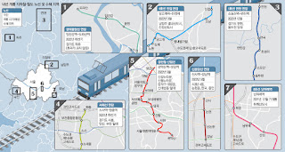
The Maeil Kyeongje's 7 projects (NB our focus below doesn't follow these numbers)

 . Line 1 extension Northwards from Soyosan Station (3 new stations - Choseong-ri, Jeongok, and Yeoncheon): 

Since this extension mostly doubles an existing train, the article logically mentions a low impact on real estate. but it does make commuting more seamless for densely inhabited parts of Yeoncheon-gun, and allows Seoulites to venture further up the Dongducheon valley (not necessarily closer to the DMZ, though: it follows the same axis in this area).

 . Line 4 extension Eastwards from Danggogae Station (3 new stations - Byeollae Byeolgaram, Onam, and Jinjeop):

To be inaugurated next March, this 14.9 km extension is a game changer for this section of Namyangju dotted with major new towns (Byeollae and Jinjeop-eup). But as usual, what a shame that such major clusters were not connected to the grid from day one. 

Of course, this means more commuter traffic for a line already supporting older generation bed towns, but it will also help one of them, Nowon, grow as a cultural hub in Northeast Seoul. Furthermore, the article reminds us of two other projects that will help cope with the flow:

  • Seoul considers doubling Line 4 with an express service for the 31.7 km section within city limits, between Danggogae and Namtaeryeong, with potentially 12 more stations concerned (all the ones connected to other lines). That would leave 12 stations with only the standard service, along with the ones in Gyeonggi-do.
  • The extension of Line 8 Northwards from Amsa Station to Byeollae Station (Gyeongchun Line) by the end of 2023 could later be prolonged to Byeollae Byeolgaram Station via a new station, Byeollae Jungang, further anchoring Byeollae to the South, and making it a transport hub east of Seoul around a decent 'Byeollae Line' backbone.

 . Inauguration of Namwirye Station (Line 8):

Located between Bokjeong and Sanseong Stations in Seongnam, Namwirye doesn't really support Wirye New Town which, as the author mentions, would have much more impact. But he's not taking into account a tramway bound to deliver the goods: the construction of the Wirye Line is just starting these days.

'#Seoul about to start the construction of its first #tramway in decades (#WiryeLine - 12 stations, 5.4 km - to open i 2025). Line announced 8 years ago (http://seoulvillage.blogspot.com/2013/08/seoul-lrt-projects-update-part-22.html) #transports' (20211220 - @theseoulvillage)


 . Gyeongui Jungang Line extension Northeastwards from Imjingang Station to Dorasan Station

In this part of Paju, as the article confirms, 'nothing to do with real estate'. This line is simply inching further towards Kaesong, now a reasonable walk away... provided of course you've got all the papers to enter the DMZ at that most strategic point. For the moment, you're mostly connecting Seoul to a giant, empty parking lot: doesn't look like many workers will commute any time soon to the Kaesong Industrial Complex... Let's hope that some day, this dead end will be prolonged into a friendlier North Korea.


 . Seohae Line extension Northwards from Sosa Station to Wonjong Station (via Bucheon Stadium Station)

As we've already seen (in "Twice upon a time in the West"), there's a lot going on around Bucheon. This vertical will split much earlier the traffic to/from Seoul between the North (Line 1) and the South (Line 7). And it will later be prolonged not only to Gimpo Airport, but also across the river, to Line 3 (Daegok Station, after a stop in Neunggok Station).

If Daegok seems a bit isolated between Goyang's 'old and new' New Towns (Ilsan to the West, Hwajeong to the East), Line 3 leads to more glamorous sites: downtown Seoul and Gangnam. And I wouldn't be surprised to see this new, vertical airport line that will go from Goyang to Hwaseong (for now, Ansan remains the Southern limit) venture further to the North-Northeast and connect to more New Towns.


 . Sillim Line inauguration (from Gwanaksan Station to Saetgang Station)

Thanks to this precious new vertical connected to Line 9 (Saetbang), Line 1 (Daebang), Line 7 (Boramae), Line 2 (Sillim), 'I live in Bongcheon-dong' will sound a lot more uplifting. But in parallel to this LRT,  Western Seoul needs more verticals (Gangnam-gu already getting it's fourth!), starting with Seobu Line...


 . Shinbundang Line Northwards extension from Gangnam Station to Sinsa Station:  

The article made its headline on the star extension because it's about real estate and money, and we're talking expensive real estate (Gangnam-daero), and expensive stations: Gangnam on Line 2, Sinnonhyeon on Line 9, Nonhyeon on Line 7, and Sinsa-dong on Line 3. No new stations, but hopefully fewer cars on the Hannam Bridge once Sinbundang's next profitable extension to the North will lead across the river and Yongsan, all the way to Yongsan Station.

*

Beyond railway and subway projects, Maeil Kyeongje also mentioned work on more sections of the capital region's Second Ring Expressway, which will definitely have some impact. But what the region needs is more public transportation, and a better dialog within Gyeonggi-do, beyond the usual Seoul-suburbs dialog.

It's always good to connect existing dots, and the Ansan-Bucheon-Goyang axis is very welcome, but no new major urban projects should be allowed without a direct connection to the network.

The problem is that Gyeonggi-do is poorly managed, and this has something to do with the way big cities compete with each other without a real regional authority. Only the State has the potential to force some collaboration, or at least more coopetition and less competition within Gyeonggi-do. The lack of political will and strategic vision results in the multiplication of projects cannibalizing each other, a suicidal rat race as the population ages and declines. Clearly, there are countless ways of spending less, better, and still generating much more value for everyone.

 
Seoul Village 2021
Welcome to our Korean Errlines! Follow Seoul Village on Facebook and Twitter, follow me on Instagram.
Download 'Seoul VillageS', the free ebook.

Bookmark and Share

* ""딱 역 3개인데, 폭발력 엄청나다"…판교 분당 부동산 난리난 이유" (Maeil Business Newspaper 20211226)
** see "Seoul subway to gain 89 km by 2025" (June 2015), "Seoul LRT Projects Update (Part 1/2)" and "Seoul LRT Projects Update (Part 2/2)" (August 2013, following "If you ain't broke, fix it: Seoul, Welfare and Railways Deficits" - July 2013). See also all subway related posts.

Saturday, November 11, 2017

Year Of The Dog (free ebook)


Initially published in French 10 years ago ('L'Année du Chien' - 'Breves', 2007), 'Year Of The Dog' remains so far my only non-fiction Seoul 'dragedie', and the only one written from a foreigner's point of view. Yet it's not my first story featuring a dog - that would be 'Le regard d'un ami' (1979), where the narrator himself is canine. 

Which, as you'll see, doesn't make me humane.

I met this dog in Sanggye-dong, Nowo-gu, along Danghyeoncheon, long before Seoul upgraded it into a park. That streamlet also appears in my essay "Inhuman, all too human Seoul" (picture of an old timer who used to grow vegetables there).

Like for 'Guisin-dong', you can download this story for free (NEW - now also free on Google Play Books).

I hope you enjoy it, but welcome any comments (e.g. on dragedies website, on Google Play Books, on Amazon...).

Stephane - November 2017
 
Seoul Village 2017
Welcome to our Korean Errlines! Follow Seoul Village on Facebook and Twitter
Bookmark and Share
Add this page to your favorites

Sunday, July 26, 2015

Urban Continuity - Susaek-Sangam project back on tracks (and over DMC Station tracks)

Seoul and Korail signed a MOU* to redevelop over 172,000 sqm now covered with tracks and railway installations, most notably Changdong Train Depot (65,000 sqm) in Nowon-gu**, and the DMC Station area (over 30,000 sqm), for which an operator should be selected by the end of the year.

I already stressed the importance of doing the right thing for the most crucial Susaek-Sangam connection in Mapo-gu (e.g. in "A solution to the Great DMC-Susaek Rift?" in the 3rd part of my 2013 focus on Songdo and the DMC ("Songdo, DMC: sequence is of the essence (Part III)").

The project will cover 27,000 sqm at Susaek Station + 3,500 sqm for DMC Station itself:


The latest rendering shows more green and openings than the one suggested in 2013, which reminded me of the Great Slab of Paris La Defense:


To ensure an even greater urban continuity between Susaek-dong and Sangam-dong / DMC, pedestrians should be able to cross Susaek-ro to the North as seamlessly as Seongam-ro to the South, and through this more porous ensemble.

This key railway hub (AREX Airport Express, Subway Line 6, Gyeongui Line train) should merge with its surroundings horizontally, unlike the initial, vertical, aerotropolis vision. Remember the old plans featuring a landmark tower, where international businessmen would only see Incheon Airport and the DMC during their trip to Korea? Even commuters should feel invited to reach beyond the hub, deep into Susaek and Sangam.

And ideally, the tracks could be covered further to the West and to the East, prolonging the
"Gyeongui Line Forest Trail - An Urban Lifeline" now in full bloom around Yeonnam-dong for its first operational summer.

(at Yeonnam-dong by day) Gyeongui Line forest trail got greener
twitter.com/theseoulvillage/status/625207215603879936

(at Yeonnam-dong by night) Gyeongui Line forest trail by night now. Good to see so many citizens adopt it, even picnic on the lawn
twitter.com/theseoulvillage/status/625274339781246976

Over the two years following that focus on the trail, my long gone "Busan Corner"*** has again changed at least twice. It just became a jewelry shop - how's that for gentrification?

Seoul Village 2015
Welcome to our Korean Errlines! Follow Seoul Village on Facebook and Twitter
Bookmark and Share
Add this page to your favorites

* see for instance "서울 수색역세권 본격 개발한다…'DMC역 구역'부터 시작" (Yonhap 20150727)
** among the 27 key redevelopments confirmed last spring (see "Diagonal crossings, High Lines, and Business Verticals (how pedestrians and businesses remodel Seoul... and vice-versa)" followed by "Urban Regeneration: 27 Projects For Seoul")
*** "Busan Corner on Taxi-daero"

Tuesday, September 2, 2014

New Town out, Redevelopment in, back to the Urban Jungle

Korean economy badly needs a boost, and the government opted for a quick fix with long lasting effects: in "the republic of apartments", easing apartment regulations always sounds like giving junkies one massive free shot (about this most typical Korean addiction, see for instance "The Republic Of Apartments", or "Inhuman, all too human Seoul").

This at a moment when the real estate market got a bit sounder, many empty apartments created by new town bubbles eventually finding tenants. And what to say of the recent easing of DTI (Debt To Income) and LTV (Loan To Value) ratios as household debt keeps skyrocketing (over 8% last year)... 

But this is less about supply and demand rationale than about giving work to construction conglomerates, and a boost to voters' morale. I don't have the details of the 30% of the 2,400 regulations that shall be dumped by 2017, but social welfare is unlikely to gain ground to short term profits. Typically, the proportion of apartments reserved for rentals in any given block will be reduced, and there will be fewer constraints on unit sizes. LH Corporation's key assets will be sold to private developers, who really seem to be the ones calling the shots here.

Not very P.C. for an administration supposed to fight speculation and defend the interest of the weakest citizens. Interestingly, the very day the set of measures were announced, Seoul Mayor Park Won-soon met with Deputy PM Choi Kyung-hwan, a first meeting at such level since 2006, to discuss collaboration on infrastructures, including facilities along Hangang riverside, and a second cable car on Namsan*.

The best measure in the package is the end of what I call the 'greenfield new towns' (see "Wet eyes for wetlands and urban mirages"): instead of improving existing neighborhoods, authorities prefer to create artificial cities ex nihilo and extra muros because land is cheaper. Now hopefully, Korea shall significantly reduce the risk of urban nonsenses.

The most anticipated measure is the reduction of minimum age requirements by up to ten years for the reconstruction of apartment buildings, which means that the bed towns erected around the Olympics in the late eighties shall be replaced much earlier.
 
Korea to cut construction regulations: no more satellite New Town, but apartment redevelopment accelerated / Urbanism deregulation means that apartment blocks in Sanggye, Mokdong or Jamsil will be redeveloped much sooner - twitter.com/theseoulvillage/status/506611541722935296
This set of maps shows the chronology of the development of habitations in Seoul (before 1980, during the 80s, 90s, and noughties).

Among the 1987 projects that could be up for reconstruction in 2017: Sanggye-dong (Jugong 3 blocks), Gaepo-dong (Useong 3 blocks), Mok-dong (5 blocks), or Apgujeong-dong (Hyundai 3 blocks). I wouldn't be surprised if the upscale Apgujeong moved first, and made the most of these tailor-suited gifts. Nowon seems also ripe, and there's a shortage of big apartments in this former bed town gone middle class. Some apartment blocks will grow taller and more exclusive, others will struggle to find investors. 

What bugs me most is what will happen to the rest of Seoul. This remains a non-zero sum where even winners in the short term can lose in the long run. Giving free reins to private developers could help speculation return to LEE Myung-bak-era levels, and torpedo the nascent efforts to develop a more consistent and sustainable urban planning. 

The risks are well known, and the cases of urban failures across Seoul already well documented. This is the last opportunity to apply a sustainable vision for urbanism in Seoul, and certainly not the moment to let anyone do anything anywhere. 

Good or bad, the years that come will define Seoul's cityscape for good, and local authorities cannot wash their hands of the future of the capital and its citizens.

Seoul Village 2014
Welcome to our Korean Errlines! Follow Seoul Village on Facebook and Twitter
Bookmark and Share
Add this page to your favorites

* e.g. Korea JoongAng Daily 20140902: "Apartments to be rebuilt sooner" and "Deputy prime minister, mayor talk cooperation"

Monday, May 12, 2014

Seoul's Big Data On Slow Motion

The densest traffic in Seoul? In front of Hongdae on Friday afternoons, according to the data crunched by Seoul (over 2013: 7.6 billion GPS records from part of the taxi fleet)*. It makes sense for a city where Hongdae, Cheonggyecheon, and Namdaemun see the slowest traffic on average, and where Friday is the slowest day (21.6 km/h), but makes me wonder if there's not a bias: in front of Hongik University Station, the right lane is very often blocked by cabs waiting for customers, with their GPS recording non-existing traffic jams... That said, let's cruise on.

Know that overall, Seoul posts a 26.4 km/h average speed: 18.7 km/h downtown (thank you Jung-gu!),  26.6 km/h in the rest of the city, and 59.9 km/h on expressways.

The following maps show averages at the district level, which is much less precise than a map of the main axis. It clearly penalizes tiny "red" Jung-gu: a significant share of its roads are perennial bottlenecks, while the much bigger Gangnam-gu compensates its notorious traffic jams with its vast quiet neighborhoods. At the geographical center of the capital, "Blue" Yongsan proves a rather efficient transportation hub. And if Seongbuk-gu comes as a surprise to you, remember that this district is home to almost half a million Seoulites, and that many Nowonites cross it every day, making circulation even more difficult between the Dongsomun-ro - Bukhansan scissors.


Average speeds per district / Weekdays on secondary roads

Weekdays / Weekend

If you want to follow in real time the traffic along Seoul's main axis, or watch live webcams along the way, visit SPATIC's website:


Seoul metropolitan Police Agency Traffic Information Center - spatic.go.kr


Seoul Village 2014
Welcome to our Korean Errlines! Follow Seoul Village on Facebook and Twitter
Bookmark and Share
Add this page to your favorites


* see "금요일 오후 홍대입구 가면 `거북이` 된다" (Seoul inews - 20140512)

Tuesday, January 21, 2014

Over the moon

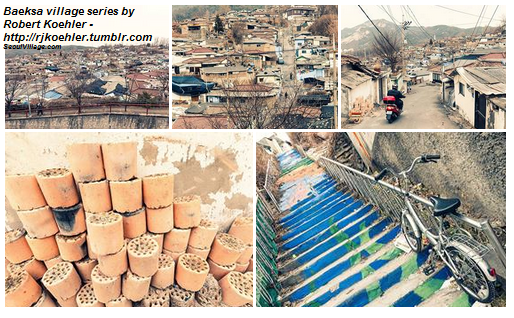
The day couldn't start any better: a beautiful series of pictures of Baeksa Village, one of my favorite 'moon villages'*. Thank you Robert Koehler!

On Robert Koehler Travel Photography site:
http://rjkoehler.tumblr.com/post/73834365491/located-in-northern-seoul-on-the-lower-flank-of
* see previous posts on Baeksa maeul:


Seoul Village 2014
Welcome to our Korean Errlines! Follow Seoul Village on Facebook and Twitter
Bookmark and Share
Add this page to your favorites
.

Wednesday, December 18, 2013

Seoul-Namyangju? Check. East Gyeonggi? Still To Be Defined

Now with the full support of Seoul, Namyangju, and the Ministry of Transport, the extension of Subway Line 4 from Danggogae Station (Sanggye-dong, Nowon-gu, Seoul) to Jinjeop Station (Jinjeop-myeon, Namyangju) shall be, as expected, delivered by 2019.

Pre-feasibility studies confirmed a project we already detailed earlier, most recently last year*:
"In a diagonal parallel to the Gyeongcheon Line (railway for Chuncheon), the 14.5 km extension from Danggogae will create three stations in the city of Namyangju: Byeollae (Byeollae-dong), Onam (Onam-eup), and Jinjeop (Jinjeop-eup). All three correspond to new towns, not to mention (see reminder) today's terminal itself, Danggogae Station, at the center of the future Sanggye New Town. I bet many inhabitants may feel more like in an extension of Nowon-gu than in a new Namyangju neighborhood: there's no direct railway connection to Namyangju city hall in Geumgok-dong, and Nowon Station with its city hall and attractions is just 1 to 4 stations away.

Sanggye, Danggogae, and Byeollae all lie along Deongneung-ro, an axis already very congested by traffic jams. The only road cutting through Buramsam (in its middle) became an important entry point into northeastern Seoul when the Seoul Ring Expressway was completed: located halfway between Uijeongbu I.C. and Guri I.C., Byeollae I.C. instantly relieved the saturated Toegyewon I.C. gateway. But the road was not dimensioned for that traffic, and turned into a bottleneck."
I positioned Danggogae, Byeollae, Onam, and Jinjeop on Seoul Village map, and as you can see, a stop in  Jinjeop-eup could be added (maybe near Naegok-ri,, between Byeollae and Onam):


View Seoul Village in a larger map

If you zoom out from there, you see how this Eastern New Town Line takes the Wangsukcheon valley towards Pocheon, not the greatest 'pull' to prolong it even further.

But again, the way new towns have been decided across the capital region never followed any grand, long term vision combining from the start urban development with transit solutions. For instance, it would have been so easy to plan an arch from Uijeongbu to Hanam via Namyangju and Guri, in order to build a strong vertical backbone for eastern Gyeonggi-do, and instead of weak horizontal fishbones sticking out from the capital, a sounder dialog with Seoul.
 
Note that this Eastern New Town Line, that has been on the map for ages, was not even mentioned in Seoul Metropolitan Rapid Transit Master Plan. Now you know why I preferred the previous 'big picture' I added in my focus, where such hubs as Nowon-Sanggye appear more clearly (see "If you ain't broke, fix it: Seoul, Welfare and railways deficits").

Seoul Village 2013
Welcome to our Korean Errlines! Follow Seoul Village on Facebook and Twitter
Bookmark and Share
Add this page to your favorites

* see "Spectacular extensions of Seoul Subway Lines 4-5-6-7 ?" (April 2010), followed by "Seoul subway updates : gos, no-gos, maybes" (January 2011) and "Nowon confirmed as Seoul's northeast hub" (October 2012)

Monday, August 5, 2013

Seoul LRT Projects Update (Part 2/2)

This post completes my tryptic on the revised Seoul Metropolitan Rapid Transit Master Plan:
Before starting, one last glance at the map...


New LRT projects in Seoul
Seoul map with the projected LRT lines: the initial 7 in black, the updated list of 10 in red, 3 potential further projects in blue

... and at the updated list of LRT lines (7 + 3 + maybe 3, see previous post), with their projected daily traffic and length:

  • 7 lines in the initial list (in black on the above map):
    • Dongbuk Line (183,276 users, 13.3 km extended to 14.3)
    • Seobu Line (163,754 users, 15.7 km extended to 19.5) - see previous post
    • Sillim Line (119,743 users, 8.9 km extended to 10) - see previous post
    • Myeonmok Line (91,472 users, 9 km)
    • Mok-dong Line (89,587 users, 10.8 km)
    • Ui-Sincheol Extension (30,227 users, 3.5 km)
  • 3 new lines (in red on the above map):
    • Wirye-Sinsa Line (168,784 users, 14.8 km)
    • Subway Line 9 Extension (65,159 users, 3.8 km)
    • Wirye (33,081 users, 5 km)
  • for the 3 potential further projects (in blue on the above map), see previous post
And remember: this is only Seoul's wishlist, n projects at various stages of maturity, not even a final proposal. Don't expect everything to happen.


Mokdong Line: a new tentacle for Line 2
I'm starting with this project today to wrap up Southwest Seoul (after the Seobu, Sillim, Nangok lines and the Hongdae-Hwagok project). The Mokdong Line seems to be doubling the Subway Line 5 and the weird Sindorim-Kkachisan tentacle that grows from Subway Line 2. Actually, "Mokdong" is basically a new L-shaped Line 2 tentacle reaching from Dangsan to Sinwol, that crosses the first one without any connection, and fundamentally brings more traffic to Line 2 and to the growing Dangsan hub. On a more positive note, it alleviates the Sindorim and Yeongdeungpo-gu Office stations, and serves more directly central Mok-dong (between lines 5 and 9), plus the westernmost neighborhoods of Guro-gu, on the outer side of line 5.
  • Fundamentally, I don't like the idea of multiplying converging lines to a saturated axis, and to see all new line projects stop at Seoul borders, as if it were a wall. Particularly when, on the other side of this frontier, Bucheon's Ojeong-gu is solely crossed by the Gyeongin Expressway. I subscribe to the ambition of having most Seoul citizens living a maximum 10 mn walk away from subway stations, but Seoul is not an island, the city must improve its dialog with Gyeonggi-do, offer alternative to cars for commuters, consider maybe a second ring beyond line 2.... Always this deficit in vision and long term impacts, but also always these political bottlenecks at the local, regional, and national levels, which tend to multiply quick fixes, and to prevent larger scale and more sustainable projects from emerging.

  • The 12 projected stations (approximative list):
    • Dangsan Station (Subway Lines 2, 9) in Dangsan-dong, Yeongdeungpo-gu: a confirmation of the Dangsan-Yeouido-Noryangjin triple hub. The Mokdong Lines heads westwards.
    • Ewha Womans University Mokdong Hospital / Wolchon Middle School at the frontier of Yangpyeong-dong, Yeongdeungpo-gu, and Mok-dong, Yangcheon-gu: a high density "apateu" neighborhood on the other side of Anyangcheon
    • Mok-dong / SBS in Mok-dong, Yangcheon-gu: on the other side of the Gyeongin Expressway / Gukhoe-daero axis, by SBS center.
    • Omokgyo Station (Subway Line 5) in Mok-dong, Yangcheon-gu: still following the general direction of the Mokdongseo-ro / Mokdongdong-ro axis.
    • Yangcheon-gu Office in Sinjeong-dong, Yangcheon-gu: the station will be close to the actual office, a couple of blocks away from the Yangcheon-gu Office Station on the older "tentacle" of Line 2... I hope they are somehow connected, or that they'll come up with a different name, otherwise we're in for another Sinchon Station mess (the Line 2 - Gyeongui Line stations share the same name but are not connected). But according to the maps, the new tentacle crosses the old one without any connecting station. I know this is a light rail, low cost project, but considering the scarcity of subway lines in this city, I don't understand how one can come up with non-intersections. This is supposed to be a network, for gimchi's sake! Granted, it's already complicated to get a train in the direction of these weird tentacles...
    • Sintree Park in Sinjeong-dong, Yangcheon-gu: at the intersection of Jungang-ro and Sinjeong-ro. Line 2 passes here, and if this Sintree Station were on line 2, it would be exactly halfway between Yangcheon-gu Office and Sinjeongnegeori Stations.
    • Seobu Truck Terminal / Yangcheon high schools in Sinwol-dong, Yangcheon-gu: at the intersection between Nambusunhwan-ro (Nambu Ringway) and Sinjeong-ro, which continues across Waryongsan to Bucheon via the Gungdong Tunnel. At one stage, a short sub-tentacle was supposed to grow from here to Sinjeong District 3 and to a line depot, but the line follows Nambu Ringway northwards
    • Gangsin Middle School in Sinwol-dong, Yangcheon-gu: further on Nambusunhwan-ro 
    • Gangwol Elementary School in Sinwol-dong, Yangcheon-gu: at the intersection with Sinwol-ro. A lot of apartment blocks have been erected to the left of these last two stations, on the eastern slopes of Waryongsan, where the sub-tentacle would have landed.
    • Sinwol Interchange in Sinwol-dong, Yangcheon-gu: at the intersection between Nambu Ringway and Gyeongjin Expressway
    • Sinwol-dong Sageori in Sinwol-dong, Yangcheon-gu: at the intersection with Garogongwon-ro, which leads to Gogang-dong, Ojeong-gu, Bucheon
    • Sinwol in Sinwol-dong, Yangcheon-gu: at the intersection with Hwagok-ro, a significant road that leads to Gayang Bridge and the DMC to the East and (as Bongo-daero) to Jakjeon Station in Incheon


Ui-Banghak Line: not so simple

After yesterday's "3-Tailed Dragon" and this new tentacle, I'm taking a break with the simpler Ui-Banghak Line. No headache here, we're only prolonging the Ui-Sinseol Line, already well under way, to Banghak Station. The vertical between Bukhansan and Line 4 will then follow the parallel all the way to Subway Line 1.

  • No headhache? Note that Ui-Sinseol basically prolongs Line 2's eastern tentacle (Seongsu-Sinseol-dong), but that's not the same technology (LRT). Note also that this is not exactly an extension, but an outgrowth starting from the next to last station (Ui - Munigyo)... do we need more sub-tentacles? Typically the consequence of short term planning.

  • The 12 initial stations (reminder) - NB: tentative names, as usual here:
    • Sinseol-dong (Subway Lines 1, 2) in Dongdaemun-gu.
    • Bomun (Subway Line 6) in Seongbuk-gu
    • Sungshin Women's University (Subway Line 4) in Seongbuk-gu
    • Jeongneung (Jeongneung Samgeori) in Seongbuk-gu
    • Kookmin University - Seokyeong University (Jeongneung-dong) in Seongbuk-gu
    • Sinmia / Dongbuk Market in Gangbuk-gu
    • Samyang-dong Samgeori / Samyang Market in Gangbuk-gu
    • Hwagyesa / Sinsuyu in Gangbuk-gu
    • Ui Elementary School / Insu / Suyu in Gangbuk-gu
    • 4.19 Memorial Cemetery in Gangbuk-gu - close to Duksung Women's University in Dobong-gu
    • Ui / Munigyo Samgeori in Gangbuk-gu
    • Bukhansan / Ui-dong Resort in Gangbuk-gu. Theoretically the beginning of the line, and the line depot.
  • 2 new stations are planned for the new Ui-Banghak Line (4 stations overall):
    • Ui / Munigyo Samgeori (Ui-Sinseol Line) in Ui-dong, Gangbuk-gu: intersection of Samyang-ro and Haedeung-ro, which the new line takes eastwards, crossing Uicheon.
    • Banghak / Ssangmun / Seondeokgogyoipgu in Banghak-dong and Ssangmun-dong, Dobong-gu: at the intersection between Haedeung-ro and Sirubong-ro, in the middle of a massive new town. The line continues eastwards then takes Dobang-ro to the left.
    • Dobang in Banghak-dong, Dobong-gu: intersection between Dobang-ro and Sirubong-ro 15-gil
    • Banghak Station (Subway Line 1) in Dobong-dong, Dobong-gu:


Dongbuk Line: The Northeastern Light Rail Highway
One of the longest projects, and the one expecting the heaviest traffic, the Dongbuk Line improves coverage in Northeast Seoul and alleviates traffic from the saturated subway lines 1 and 4. Starting from Wangsimni Station, it initially stopped at Eunhaeng Sageori, but has been stretched to Sanggye Station.

  • Wangsimni confirms its role as a major hub west of the city center. Seoul takes care of its bed towns on the way, but doesn't extend the hand to the other side of Buramsan (well in the first place, Gyeonggi-do didn't plan any railway for its own New Towns there - a total nonsense for XXIst century urban planning).

  • Projected stations (tentative list):
    • Wangsimni Station (Subway Line 2, 5, Jungang Line) in Haengdang-dong, Seongdong-gu
    • Doseon Sageori in Doseon-dong, Majang-dong, and Hongik-dong, Seongdong-gu: intersection of Gosanja-ro and Majang-ro
    • Jegi-dong Station (Subway Line 1) in Yongdu-dong and Jegi-dong, Dongdaemun-gu. Note that we could have stopped on the way at Yongdu Station in the eastern tentacle of Line 2.
    • Korea University Station (Subway Line 6) in Jongam-dong, Seongbuk-gu, Cheongnyangni-dong, Dongdaemun-gu
    • Sungnye Elementary School in Jongam-dong, Seongbuk-gu: along Jongam-ro
    • Jongam in Jongam-dong, Seongbuk-gu
    • Miasamgeori Station (Subway Line 4) in Songcheon-dong and Songjung-dong, Gangbuk-gu. From then, the line follows the Wolgye-ro diagonal
    • Odong Park - Dream Forest in Songjung-dong, Gangbuk-gu
    • Dream Forest in Beon-dong, Gangbuk-gu, and Jangwi-dong, Seongbuk-gu
    • Wolgye Station (Subway Line 1) in Wolgye-dong, Nowon-gu: then, the line crosses Jungnangcheon, and Wolgye-ro becomes Hangeulbiseong-ro
    • Hagye Station (Subway Line 7) in Hagye-dong, Nowon-gu: and the new SeMA Nowon
    • Daejin High School in Hagye-dong, Nowon-gu: intersection Hangeulbiseong-ro / Nowon-ro
    • Eunhaeng Sageori in Junggye-dong, Nowon-gu: intersection Hangeulbiseong-ro / Junggye-ro (reminder: walk up that street to reach Baeksa Maeul). Where the line stopped in previous plans.
    • Sanggye Station (Subway Line 4)

Myeonmok Line: Eastern Eggs
Starting from Cheongnyangni, the Myeonmok Line covers a triangle between subway lines 1, 5, and 7 in Dongdaemun-gu, and almost reaches subway line 6 in Sinnae-dong, on the other side of the Jungang Line.

  • Private investors are interested by this line. Maybe because it can easily be prolonged, at a cheaper cost than line 6, to the Namyangju New Towns that will necessarily have to be connected some day. And speaking of connections, this line ignores the old Jungan Line as well as the Bonghwasan terminus of Line 6.

  • Projected stations (tentative list):
    • Cheongnyangni Station (Jungang Line, Subway Line 1) in Jeonnong-dong and Cheongnyangni-dong, Dongdaemun-gu.
    • University of Seoul in Jeonnong-dong, Dongdaemun-gu: the gate at Seoulsiripdae-ro and Jeonnong-ro
    • Jeonnong-dong in Jeonnong-dong, Dongdaemun-gu
    • Jangan-dog Sageori in Jangan-dong, Dongdaemun-gu: at the intersection of Dapsimni-ro and Jangan-ro, the line continues along the former, crosses Jungnangcheon
    • Myeonmok / Myeongmokcheon-ro in Myeonmok-dong, Jungnang-gu
    • Myeonmok Station (Subway Line 7) in Myeonmok-dong, Jungnang-gu
    • Dongwon Sageori / Gyeomjae Samgeori in Mangu-dong, Jungnang-gu
    • Yongmasan in Mangu-dong, Jungnang-gu: intersection Yongmasan-ro / Bongujae-ro, former Yongmaland amusement park
    • Mangu Sageori in Mangubon-dong, Mangu-bong, Jungnang-gu: intersection Yongmasan-ro / Mangu-ro - NB: we're passing between the Mangu and Yangwon stations of the Jungan Line, but no connection...
    • Jungnang-gu Office in Sinnae-dong, Jungnang-gu
    • Neungsan Samgeori in Sinnae-dong, Jungnang-gu
    • Sinnae in Sinnae-dong, Jungnang-gu


Wirye Sinsa Line & Wirye Line: New Town, Old Routes
At the frontier with Seongnam, Wirye New Town (Geoyeo-dong and Jangji-dong, Songpa-gu) gives its name to two projects:
  • The Wirye Line is an omnibus crossing the whole new town with 9 very close outdoor stations (it really looks like the Paris Tramway), and perfectly connected on both sides to existing subway lines (Macheon on line 5, Bokjeong on lines 3 and 8). Again, I'm not a fan of new town, but I would never allow any major project that doesn't from day one include a robust railway backbone, and this one has at least that right. Do we need 9 stations, and did we need this new town in the first place, that's another question.

  • The Wirye Sina Line does more than connect this new block to the grid: it goes all the way through to Sinsa, and I think this area has already seen many new lines in a recent past. Almost 15 km of essentially redundant lines, THAT's probably way too much.
    • The line would start from the lower third of the new town (7th station out of 9 on Wirye Line), follow line 8 around Jangji-Munjeong, until Garak Market. This first stretch is totally redundant and disproportionate. Remember, Wirye Line IS already connected to Line 8. Had this WSL started from the 5th station of the WL, and added a brand new station in the middle of non covered land (Munjeong-dong - Jangji-dong, halfway to Garak Market) it would still look too much.
    • After Garak Market, miracle: a new station in a less covered place (even then, Garak-1-dong is close to Songpa Station. WSL follows Tancheon and Tancheondong-ro, but I don't see any station on that long stretch... which line 9 is supposed to be covering soon anyway. So here again, almost total redundancy.
    • What next? WSL goes north, crosses lines 2 (Samseong Station), 9, and 7 (Cheongdam Station). Then it becomes a parallel to the same lines 2, 9, and 7, that will meet the soon to be extended Bundang Line, and meet Line 3.

Line 9 Extension
From the start, the Subway Line 9 Extension tells a lot about the failed Subway Line 5 fork. Forks and tentacles are not natural forms for railways. Line 9 will basically follow this vertical from Seoul Veterans Hospital (Dunchon-dong, Gangdong-gu) to Godeok Gangil District 1 (Godeok-dong, Gangdong-gu), but frankly prolonging subway line 8 would have done the job. It's just that while many neighborhoods have yet to see a railway line, some love to build three or four parallels just for fun. Okay. I'm getting tired here. And it's good to have a line (9) that crosses the whole city - and I hope, one day, beyond (I already wrote that I expected one of these lines to reach to Guri and Hanam. Someday).


*


Now if you don't mind, I'll drop the maps and take a nap.

Until the next batch of projects.


Seoul Village 2013
Welcome to our Korean Errlines! Follow Seoul Village on Facebook and Twitter
Bookmark and Share
Add this page to your favorites

* see "'서울 어디서나 도시철도 10분' - 철도 중심시대가 열립니다" (seoul.go.kr 20130725)