NEW - download 'Seoul VillageS (서울 마을들)', my collection of 12 short fictions now adapted into short films! Get your free copy of the ebook (4 editions: English, French, Korean, Bilingual English-Korean)!

Showing posts with label Dorimcheon. Show all posts

Friday, April 29, 2022

Seoul's Waterfront Renaissance

Seoul has always been defined by its most valuable environmental assets: its countless waterways, and the mountains that feed them. 

From the start, the capital revolved around Cheonggyecheon and its network of streamlets:

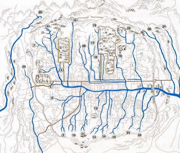
Nowadays, the Han River tells what's North and what's South, but waterways still account for 8.1% of Seoul's land (below in 2010):

After pouring concrete all over the place to tame the powerful Hangang and its tributaries, to stabilize unstable riverbanks, and to prevent recurring floods, the city has reopened its heart to its waterways, rediscovered them as leisure paths and environmental treasures. Following the restoration of Cheonggyecheon, the Hangang Renaissance, and the restoration of neighborhood streamlets, masses of humans, birds, and even fishes have flocked back to Seoul's watersides. Yes, more concrete was often poured in the process, but biomass keeps growing, embankments are often doubled with natural fish nurseries, and significant wetlands have been created.


Citizens are already very active along these waterways, thanks to all the infrastructure needed by strollers, cyclists, or workout maniacs:

But water level and street level are seldom seamlessly connected, and for good reasons: flash floods remain a constant threat, and these waterways help the city cope with extreme downpour. On such occasions, riversides must be evacuated immediately. Still, more citizens could spend more leisure time there, particularly when they crave for more free and cool open spaces.

More than a decade after his Hangang Renaissance project, Mayor OH Se-hoon aims at a 'Jicheon Renaissance' leveraging Seoul's 332 km of waterways. Not just with more hardware, but with more content and culture, a better connection to local neighborhoods and markets, More 'emotion', as part of an 'Emotional City' of the future vision.

Starting with 4 pilot projects along three streamlets (Dorimcheon, Jeongneungcheon, and Hongjecheon), with 2 more sites by 2030 (Anyangcheon and Jungnangcheon):

  • Hongjecheon will never fulfill its great potential as long as the Naebu Expressway disgraces it (see "Along Hongjecheon, my way or the highway"), and the pilot will focus on two spots: upstream at Hongjimun and Tangchundaeseong, midway at the artificial waterfall near Seodaemun District Office, with a place to have a drink.


  • Dorimcheon is more about the connection to the neighborhood and its businesses, with decks to make the transition and chill out:


  •  Jeongneungcheon will add a cultural layer through a new media art space:


Of course, all this requires water, particularly since the city intends to make these shallow streamlets a bit deeper (from a very thin 10 cm to a more significant 30 cm). So backstage, there's a lot of work to improve water and waste management. 

Today, 18 streamlets including Cheonggyecheon are actually fed with water recycled from the Han River, and climate change has spectacularly dried up the whole nation. Even if I knew Seoul experienced very few precipitations last Winter, I was stunned to see in a recent treck up Bukhansan, how parched soils were. But the only time water streamed by was magical:

As usual, I guess we'll have more imperfect, odd spaces requiring some improvement in further iterations. But overall, Seoul keeps democratizing access to quality time and nature, even if that's in not so natural spaces.

Seoul Village 2022
Welcome to our Korean Errlines! Follow Seoul Village on Facebook and Twitter, follow me on Instagram.
Download 'Seoul VillageS', the free ebook.
Bookmark and Share


Sunday, August 4, 2013

Seoul LRT Projects Update (Part 1/2)

Here's the promised focus on the 10 Light Rail Transit lines proposed in the revised Seoul Metropolitan Rapid Transit Master Plan*... Or at least the first half (I told you it would take time!):
So. Again, overall, I strongly support the development of new railways across a metropolis that lags behind its global rivals in that most crucial field, and I'm happy to see major holes in the net fixed, but I want to be sure that the right priorities are set, particularly considering Seoul's limited financial resources, and the usual suspicions surrounding grand scale infrastructure projects popping up out of the blue a few months before mayoral elections.

And again, at the macro level, the master plan didn't lay out a clear strategic vision based on the existing situation and the challenges to come, which didn't help challenge the priorities, including at the micro level we're about to investigate now.

Are we missing something? And in case a trade-off were needed, which lines should be kept and which ones should be dumped? I wish I had all the answers and all the elements.

And remember: this is only Seoul's wishlist, n projects at various stages of maturity, not even a final proposal. Don't expect everything to happen.


The full (?) list of future LRT lines: from 7 to 10 (to 13?)


First, two maps (I told you, I love maps). I already showed you the first one, a "before-after" Seoul where each orange dot corresponds to a 10 min. walk around one railway station:


before and after the new lines - about this map, see previous post

The second map presents all the lines I'll list below:


New LRT projects in Seoul
Seoul map with the projected LRT lines: the initial 7 in black, the updated list of 10 in red, a 3 other projects in blue


Here's the revised list of ten LRT projects (starting with the initial list of 7, in black on the map / the last 3 - in italic, in red on the map - have just been added), with their projected daily traffic and length:
  • 7 lines in the initial list (in black on the above map):
    • Dongbuk Line (183,276 users - 13.3 km extended to 14.3)
    • Seobu Line (163,754 users - 15.7 km extended to 19.5)
    • Sillim Line (119,743 users - 8.9 km extended to 10)
    • Myeonmok Line (91,472 users - 9 km)
    • Mok-dong Line (89,587 users - 10.8 km)
    • Nangok Line (54,247 users - 4.1 km)
    • Ui-Sincheol Extension (30,227 users - 3.5 km)
  • 3 new lines (in red on the above map):
    • Wirye-Sinsa Line (168,784 users - 14.8 km)
    • Subway Line 9 Extension (65,159 users - 3.8 km)
    • Wirye (33,081 users - 5 km)

Seoul says 10,000 users are enough to make a line profitable (regardless of its configuration?). Note that for the moment, private investors have already shown interest in two lines: Seobu and Myeonmok.

3 other LRT projects (in blue on the above map) shall be considered 5 years from now, provided the conditions change favorably:


  • A further Subway Line 9 extension: from Godeok-Gangil District 1 to Gangil-dong, Gangdong-gu on the other side of the circular expressway 100, in the westernmost section of Seoul, right before Hanam. Reminder: back in 2010, Subway Line 5 was the one supposed to be prolonged to Hanam (see "Spectacular extensions of Seoul Subway Lines 4-5-6-7 ?")

  • A Hwagok-Hongdae Line that, judging by the sketches, would start from Hongik University Station, cross the DMC along Worldcupbuk-ro, take the Gayang Bridge across the Han river, and follow Hwagok-ro to Hwagok Station (Hawgok-dong, Gangseo-gu), joining subway lines 2, 6, 9, and 5 in the process. It would add a precious vertical link within Southwest Seoul (nothing outside of the Subway Line 2 ring), and bring the western halves of the city closer together (not to mention the DMC and Magok District). While Seoul is at it, why not consider a more ambitious second ring? Expensive, I know, but always keep an eye on the big picture


Now back to this list of 10. I'll start with the longest, the one that fills the biggest hole in Seoul's railway network, and the one I mentioned yesterday (see "Yonsei-ro the first street in Seoul to ban cars in its transportation mix"): Seobu Line. But I cannot do that without mentioning two shorter lines that are connected to it: Sillim and Nangok.


A 3-Tailed Dragon or the Seobu / University Line all the way?

  • If you see the proposed network, 3 new vertical LRT lines are connected to each other, like a 3-Tailed Dragon:
    • Seobu Line - The longest and most structural project: a vertical through Western Seoul (thus the name) that to the North fills the biggest hole in the network (around Eunpyeong-Seodaemun), and to the South cuts halfway between the too distant verticals of lines 2 and 4 (Dongjak-gu, Gwanak-gu). Between the two stretches, Seobu Line crosses Mapo-gu and doubles the horizontal line 9 through the saturated Yeouido hub. In previous plans, the line stopped halfway between Yeouido and Seoul National University Station.
    • Sillim Line - A vertical between Yeouido and Sillim-dong, but more to the west (closer to Line 2, at the Yeongdeungpo-gu / Dongjak-gu border), and reaching deeper to the south, to east-Sillim-dong (Sinwon-dong, Seowon-dong, Seorim-dong, Sillim-dong)
    •  Nangok Line - Around its middle (Boramae Park Station), where the Sillim Line becomes a diagonal, this vertical heads straigth to the south and west-Sillim-dong (Jowon-dong, Miseong-dong, Nangok-dong, Nanyang-dong)

  • Frankly, I don't believe in a "3-Tail LRT Dragon" scenario where all 3 lines (Seobu, Sillim, Nangok) get the nod. Among the possible scenarii:
    • If your priority is to reach SNU (that's a joke), you don't need a Sillim Line, and all you have to do is to add one "Inside SNU" station after Seoul National University Station via Gwanak-ro.
    • If you want to keep only one project, and if you consider that the Sillim Line vertical is less central than Seobu to fill the Line 2 - Line 4 gap, you can keep the Seobu Line all the way to Guam station, finish with the last 3 stations of the Sillim Line to serve Sillim-dong (plus SNU if you insist!) and, to draw a straighter line between both segments, to replace Seoul National Station with Bongcheon Station, and Euncheon Samgeori station with, say, a station at the intersection of Euncheon-ro and Yangmyeong-ro.
    • If you can only afford two lines, you can keep the modified Seobu Line I just described, and a combination of Sillim and Nangok (Yeouido-Boramae Park-Nanyang)


Seobu Line (approximative) list of stations
Seobu Line shall run from Saejeol Station in Eunpyeong-gu to Seoul National University Station in Gwanak-gu (in previous plans, it stopped at Jangseungbaegi Station):
  • Saejeol Station (Subway Line 6) in Sinsa-dong, Eunpyeong-gu: where Gajwa-ro, a major diagonal axis in Seodaemun, crosses Bulgwangcheon
  • Chungamgo Samgeori in Eungam-dong, Eunpyeong-gu (Baengnyeongsa: in front of Choongam High School, at a strategic fork betweeen Gajwa-ro and Baengnyeongsan-ro, which borders the recently erected Eungam New Town. After that, the line continues along Gajwa-ro and turns right at Geobukgol-ro, where it reaches the next station.
  • Myeongji University in Namgajwa-dong, Seodaemun-gu: the first major university on this line (Myeongjidae), with another new new town, Gajwa New Town. Another right angle but to the left this time: the line follows Jeungga-ro, crosses Hongjecheon to reach the center of Yeonhui-dong.
  • Yeonhui in Yeonhui-dong, Seodaemun-gu: at Yeonhui Samgeori (intersection between Jeungga-ro and Yeonhui-ro), near Yeonhui Elementary School. The line takes Yeonhui-ro to the right, then Seongsan-ro to the left.
  • Yonsei University in Sinchon-dong and Changcheon-dong, Seodaemun-gu: at the main gate of the university, in front of Yonsei-ro. About the impacts between this station and the next one (and my wish to see a connection with the Sinchon Station of the Gyeongui Line), read "Yonsei-ro the first street in Seoul to ban cars in its transportation mix".
  • Sinchon Station (Subway Line 2) in Changcheon-dong, Seodaemun-gu and Nogosan-dong, Mapo-gu. University-wise, that's very close to the entrance of Seogang University, and one station away from Hongdae and Ehwa. Note that we just passed 4 new stations since Line 6: if you look back to the "before-after" map, that fills the "white" triangle in Northwest Seoul.
  • Gwangheungchang Station (Subway Line 6) in Seogang-dong, Mapo-gu: we've been following Seogang-ro from Sinchon Rotary, and will continue straight across the Han river to Yeouido under the Seogang Bridge, where the avenue becomes Gukhoe-daero.
  • Seogang Bridge Southern End (Seogangdaegyonamdan Sageori) in Yeoui-dong, Yeongdeungpo-gu: at the intersection of Gukhoe-daero and Yeouiseo-ro. Instead of continuing straight and joining National Assembly Station, the Seobu Line takes Bokeum-gil to the left to draw a parallel to Subway Line 9, both lines cutting Yeouido in 3 almost equal slices.
  • MBC (Munhabangsong ap - Potential connection to Sillim Line?) in Yeoui-dong, Yeongdeungpo-gu: on the other side of the park, we're now on Gukjegeumyung-ro, at the intersection with Yeouinaru-ro, exactly halfway between Yeouinaru and Yeouido stations (Subway Line 5), less than 400 m on each direction on . It would be completely stupid not to make a direct connection with Yeouido Station, which is also on Subway Line 9: a simple corridor would do. But there is also a potential connection with the future Sillim Line (LRT), in case both are built. Note that 3 years ago, no connection was planned and that was quite a shock.
  • Yeouido St.Mary's Hospital in Yeoui-dong, Yeoui-gu: at the Catholic University of Korea hospital, where Gukjegeumyung-ro meets Yeouidong-ro.
  • Noryangjin Station (Subway Lines 1, 9) in Noryangjin-dong, Dongjak-gu: beyond the old fish market, a significant transportation hub, even if Seoul city has sidelined Noryangjin New Town. The line heads south, following Jangseungbaegi-ro, drawing a vertical line halfway between Subway Line 2 and Subway Line 4.
  • Jangseungbaegi Station (Subway Line 7) in Sangdo-dong, Dongjak-gu: typically, line 7 runs for 7 stations between line 2 and line 4 without meeting any other line, and Jangseungbaegi is the one in the middle.
    THIS IS WHERE SEOBU LINE STOPPED IN PREVIOUS PLANS.
  • Sinsangdo in Sangdo-dong, Dongjak-gu: that's the intersection of Jangseungbaegi-ro and Yangnyeong-ro, which the Seobu line will follow after that.
  • Guam in Bongcheon-dong, Gwanak-gu: more precisely at the intersection of Euncheon-dong, and Seonghyeon-dong, an area densely populated, on the other side of the Yangnyeong Tunnel. The line then takes Euncheon-ro to the left.
  • Euncheon Samgeori in Bongcheon-dong, Gwanak-gu: at the intersection of Euncheon-ro and Gwanak-ro (between Seonghyeon-dong, Jungang-dong, and Haengun-dong). The line takes Gwanak-ro to the right.
  • Seoul National University Station (Subway Line 2) in Bongcheon-dong, Gwanak-gu: on the stretch of 6 stations between Daerim and Sadang, Bongcheon Station would have been more central.


Sillim Line (approximative) list of stations
Sillim Line shall run from Yeouido to Nanhyang-dong:

  • MBC (Projected station - Seobu Line) in Yeoui-dong, Yeongdeungpo-gu: see above
  • Saetgang Station (Subway Line 9) in Yeoui-dong, Yeongdeungpo-gu: where the line used to start before someone realized it would be interesting to connect the line with Seobu. The line takes Yeouidaebang-ro, towards South-Southwest.
  • Daebang Station (Subway Line 1) in Daebang-dong, Dongjak-gu: at the intersection with Noryangjin-ro.
  • Seongnam Middle & High School in Singil-dong, Yeongdeungpo-gu and Daebang-dong, Dongjak-gu
  • Boramae Station (Subway Line 7) in Singil-dong, Yeongdeungpo-gu and Daebang-dong, Dongjak-gu
  • Boramae Park (LRT Nangok Line?) in Sindaebang-dong, Dongjak-gu: at the park and hospital. That's where Nangok Line is supposed to start. The Sillim Line heads to the East along Bongcheon-ro.
  • Danggok Sageori in Boramae-dong and Sillim-dong, Gwanak-gu: the intersection with Sillim-ro, which the line will take towards South
  • Sillim Station (Subway Line 2) in Sillim-dong, Gwanak-gu: the Sillim line will reach for the serpentine Dorimcheon
  • Dorimcheon in Seowon-dong and Seorim-dong, Gwanak-gu: near the second Sillim Bridge.
  • Sillim-ro near Sinseong Elementary School in Seorim-dong and Daehak-dong, Gwanak-gu: back to Sillim-ro, heading in the direction of SNU. On the other side of Dorimcheon starts Hoam-ro, along which Sillim New Town is under construction. Hoam-ro leads to Nangok-ro and Nanhyang-dong, where the Nangok Line ends. A potential Sillim Loop Line?
  • Seoul National University main gate in Sillim-dong, Gwanak-gu: main gate, at the intersection with Gwanak-ro.

Nangok Line (approximative) list of stations
Nangok Line shall run from Boramae Park to Nanyang-dong:

  • Boramae Park (LRT Sillim Line?) in Sindaebang-dong, Dongjak-gu: see above
  • Sindaebang Station (Subway Line 2) in Sindaebang-dong, Dongjak-gu and Sinsa-dong, Gwanak-gu: the line follows Nangok-ro
  • Nangok Sageori in Miseong-dong, Gwanak-gu: intersection with Munseong-ro
  • Nangok-dong in Nangok-dong, Gwanak-gu: the heart of a small valley of Gwanaksan.
  • Nanhyang-dong in Gwanak-gu: a cluster of apartments, and if you continue, Huam-ro, Sillim New Town (see above) 


Seoul Village 2013
Welcome to our Korean Errlines! Follow Seoul Village on Facebook and Twitter
Bookmark and Share
Add this page to your favorites

* see "'서울 어디서나 도시철도 10분' - 철도 중심시대가 열립니다" (seoul.go.kr 20130725)

Monday, December 26, 2011

Six lanes of traffic

If you want to open a shop in Seoul, the three most expensive places per square meter are Myeongdong, Hongdae, and Daehangno. And if you consider neighborhoods with the highest total value for commercial space, you get the same trio, followed by Gangnam Station (Cheongdam-dong / Nonhyeon-dong, Gangnam-gu), Sillim-dong (Gwanak-gu), and Geondae (Konkuk University, Gwangjin-gu).

Perennial leader Myeong-dong became a shopping mecca under the Japanese occupation, leveraging massive foot traffic between old and new commercial or financial centers (Namdaemun, Chungmuro, Uljiro...), at the feet of the cathedral. That's where the first neon signs were displayed in Korea, where the National Theater was inaugurated in the mid thirties (it reopened a couple of years ago as Myeongdong Theater), and where students have met for generations, now joined by tourists from all horizons.

Gangnam Station is of course a much more recent hotspot. But not the 'hot' kind of hotspot, even if it is close to key neighborhoods. To start with, the name is some kind of a drag: many images come to you when you hear Apgujeong-dong, Cheongdam-dong, Nonhyeon-dong, or Sinsa-dong,but when you hear Gangnam Station, you don't even see an old-style train stationon - just a subway entrance by a highway intersection. This busy business hub has yet to develop its own soul, an identity beyond a crossroads that happen to be where the Hannam Bridge axis meets Line 2. Yes, that's also where buildings grew taller before the rest of Teheran-ro (except for the COEX), and where the first major netcos gave birth to Teheran Valley. But the first real landmark (Kukkiwon doesn't count) is very recent... and I don't know if the new Samsung headquarters can give more purpose to the area: architecturally, the place could have used more "roundness" and openness. In a nutshell: Gangnam Yeok? a good place for business.

All other members of this Top 6 are university areas, with Hongdae leading the pack, stronger than ever. The brand has gained international recognition, but commercial space is becoming prohibitive for smaller fishes, and they're sometimes driven away to nearby dongs by big franchises. Those guys tend to make all popular areas look the same, and that's not what you want for a trendsetting hotspot boasting the ultimate indie spirit. But as long as Hongik University stays here, the fabled Hongdae spirit shall survive. And traffic is not bound to slow down: Hongdae Ipgu is now connected to both airports via the AREX, new infrastructures will bring Sinchon even closer, and the whole area will get a boost from the downtown-Yongsan-Yeouido-DMC business ring.

Daehangno survived even after Seoul National University moved to the other side of the Han river. Better: the move triggered a revolution that turned the historic birthplace of Korean university* into a cultural hotspot, aspiring venues from yet another university neighborhood, Sinchon. From Sinchon to Daehangno to Hongdae...

... Next stop: Geondae? Probably not. The place probably went up in the rankings following the construction of the Star City complex, just south of the university (not in Mojin-dong but in Jayang-dong). A major real estate operation... and the perfect occasion to fill a void for shoppers in Eastern Seoul.

I'd like to finish with Sillim-dong. Neither for its prestige (as the gateway to Seoul National University, with a strong major in law studies), nor for its less glamour, night birds side of the coin (Nokdu-geori): I have a special affection for the place because of its natural landscape, or rather what's left of it. Take out all those ugly constructions and just keep Dorimcheon serpenting peacefully between the small hills at the foot of Gwanaksan, and potentially you've got one of the city's most charming sceneries. Of course, it's probably too late to save this gem: the stream is already covered with concrete, and the future Shillim New Town already destroyed Wonsi-gil... OK time for me to get off my high horse.

Seoul Village 2011
NEW : follow Seoul Village on
Facebook and Twitter

* That was long before SNU - a relative newcomer -, Sungkyunkwan a.k.a. Taehak (a charming place to visit).

Monday, February 15, 2010

Subway news : Sillim line, Line 3...

Next month, Seoul will decide among the two finalists (NamSeoul Light Rail Ltd and Yeouido Sillim Light Rail Co., Ltd.) the winning consortium for its future Yeouido-Sillim (여의도-신림) Light Rapid Transit line. Construction shall start in 2012 for an inauguration in 2017 and by then, a complete Southwest - Northwest Seoul connection should be operational : other LRT sections are planned between Eunpyeong-gu (ie Eungam-dong) and Yeouido via Seodaemun-gu (ie Yeonhui-dong).

This new line will start from Gwanak-gu and Seoul National University, but at the very gates, not at the existing station. It will follow Dorimcheon, the stream serpenting across Sillim-dong which give the area a unique charm, and head North towards Yeouido (Saetgang Station, Line 9) via Sillim Station (Line 2), Boramae Park (Line 7) and Daebang Station (Railway).


Overall : 7.82 km and 10 stations including 6 brand new ones. That will add some verticality badly needed by a network that's desperately horizontal in this part of the Capital (only Line 4 is heading straigth South, but that's East of Gwanaksan).

If this line makes perfect sense, I'm not sure Sillim-dong can keep the unique charm I mentioned earlier : high buildings are step by step masking the exceptional natural site around Dorimcheon (please preserve the hills !), and a major cluster will bloom along Hoam-gil on the way to Geumcheon-gu : Sillim New Town. I'm sure the place will be much more popular and more fun in 2017, but it probably won't be the same...

More immediate changes ? Line 3 is about to inaugurate 3 new stations this Thursday, February 18th, 2010. Instead of finishing in Gangnam-gu at Suseo Station (Bundang Line), the orange line will cross Songpa-gu (Garak-dong and Ogeum-dong) :
- connection with Line 8 at Garak Market Station
- new station : National Police Hospital
- connection with Line 5 (a line already met at Jongno-3-ga Station) at Ogeum Station

This extention confirms the importance of the Seongnam-Gangnam corridor, but instead of just commuting, why not visit the Garak wholesale market ? Definitely less cute than your local traditional market (except maybe for informal merchants at the entrance), but quite impressive : the merchandise is more often exposed in bulk than packaged, and depending on the season you can see whole hangars filled with onions or watermelons.

That said, yet, what we got here is yet another line stopping short of entering Hanam... Line 9 seems in a better position to do so (via Gambu-dong), unless Line 5 prolongs via Macheon-dong or Mangwol-dong. The other end of Line 3 has a brighter perspective, for beyond Goyang (today's terminus : Daehwa-dong, KINTEX), and towards West Paju.

Seoul Village 2010

books, movies, music