Last spring, I visited their facilities in Gungnae-dong, Bundang-gu, Seongnam-si, Gyeonggi-do. A great moment! That's where they monitor the traffic for the whole nation, and where they broadcast 176 updates every day.
 |
| And live from Korea expressways main broadcasting station twitter.com/theseoulvillage/status/482092363821481984 |
 |
| From Korea Expressway's control room twitter.com/theseoulvillage/status/488670603504005120 |
They're also right at Seoul's main gateway. You know how much I love to wander along Seoul alleyways, but I must confess that I enjoyed overlooking tens of lines of traffic from the rooftop of that tollgate:
This four-decade-old structure stretches for 400-500 m over Korea's main backbone: Gyeongbu Expressway, a.k.a. Expressway No. 1. The site reminded me how freeways can be at the same time fantastic connectors, great dividers, and awesome destinations.
*** HIGHWAYS AS CONNECTORS ***
Korean regions are much better interconnected than they were a couple of decades ago, and from 3,762 km in 2013, the national expressway network will grow to 6,160 km by the end of the decade. If the old Seoul-Busan diagonal remains clearly visible, the grid will be more balanced, with 7 North/South and 9 East/West axes. All points on mainland shall be within only 30 mn from an exit.
 |
| The network now and tomorrow (Korea Expressway Corporation - ex.co.kr) |

When Beijing's building its 7th ring road (940 km), Korea's capital region is still working on its 2nd belt: after the "100", Sudogwon's "400" will connect Incheon, Ansan, Songsan, Bongdam, Osan, Ichon, Gangsang, Yangpyeong, Hwado, Pocheon, Paju, and Gimpo.

*** HIGHWAYS AS DIVIDERS ***
Of course, highways are not necessarily a sign of progress, and many in Korea still believe that adding roads is the only solution to all traffic problems. And even before talking about induced demand: how many times did we see public transportation systems be considered only after the construction of a New Town?
Cities and highways are mutually exclusive, that's why everything must be made to prevent them from meeting. That's also why Los Angeles cannot be considered a city, and Seoul is struggling to survive. And don't try to limit direct contacts at ground level by elevating the roads: it only worsens the situation (see for instance "Along Hongjecheon, my way or the highway").
Beltways that actually relieve urban centers can be a lesser evil, but even they can increase traffic and environmental damage (see for example the not really discreet Incheon-Ansan section of Seoul's second belt in the 2nd part "Connectivity, Continuity and Consistence" of my "Songdo, DMC: sequence is of the essence" trilogy).
Now back to that tollgate and Expressway No. 1. The view below illustrates how that Amazon of concrete divides the landscape even more dramatically than a natural or political border - hard to tell if the odds for a pedestrian to survive a crossing are better than at the DMZ:
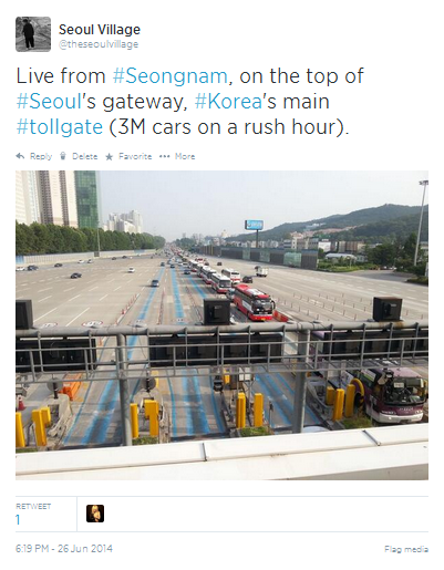 |
| Live from Seongnam, on the top of Seoul's gateway, Korea's main tollgate (3M cars on a rush hour). twitter.com/theseoulvillage/status/482090698359832576 (NB: West to the right, East to the left) |
- To the East, Bundang stretches its 'apateu' blocks around Tancheon stream.
- To the much West, from the green slopes of Gwanggyosan, the narrow valleys of Gungnae-dong and Geumgok-dong join Daewangpangyo-ro, a road parallel to the freeway from Geumgok I.C. (South) to Seoul beltway #100 via Pangyo New Town (North).
- In the center, Expressway No. 1 and its tollgate bulge (reminds me of the boa that swallowed an elephant in 'Le Petit Prince'):
 |
| The tollgate from above (NB: West to the left, East to the right) |
I clearly remember watching, during the nineties, Bundang New Town rise from a sea of cranes, while the suburbs on the Western side remained stuck in time - and the mountains relatively spared.
I also remember wondering why natural embankments were not included in the New Town's original master plan: instead of the usual sinister noise barriers, green slopes would have made that side of the freeway much more pleasant. I knew that it took more space, but when you build a town from scratch, you shouldn't compromise on key elements that impact its sustainability and its perception both from the inside and from the outside...
Pangyo New Town didn't fare much better a couple of years later (see "Pangyo from scratch to crash"): noise barriers? checked - elevated highway? checked... Of course urban planners didn't seize the opportunity to cover a wide section of the highway between Bundang and Pangyo...
But I've already spilled way too much venom on Korea's New Towns here and there, and they're not the topic of the day. Furthermore, 'greenfield new towns' like Bundang now belong to the past (see "New Town out, Redevelopment in, back to the Urban Jungle").
*** HIGHWAYS AS DESTINATIONS ***
Many people see highways as tunnels in time, a moment when life is suspended between a departure and a destination, a lost moment. But the path is a destination in itself, and freeways remain an eternal source of inspiration - beyond the vast 'road movie' culture.
Smooth roads, green rest areas equipped with showers, lounges, and free wi-fi... the freeway experience in Korea has nothing to do with the nightmare of yore, and the people in charge are fully aware of importance of always improving safety and quality, of making the most of existing infrastructures (e.g. solar energy production on abandoned roads). They truly care about - yes - your happiness.
So if you drive during this Chuseok break, even if you are stuck in thick traffic, relax.
And don't hesitate to stretch time. Don't forget to take a break every two hours, the rest areas are also here for that. Why not opt out and back in, seize the opportunity and discover a part of Korea you didn't plan to see?
 |
| With my new friend in Gangwon-do. Her potatoes were fantastic, and her joy illuminated our day. twitter.com/theseoulvillage/status/483117975265087488 (Last June, during a trip in Gangwon-do, we were invited to Gwirae-myeon, Wonju-si. Now bypassed by a bigger road, the village has seen many shops and restaurant close, which gives it a very special atmosphere) |
Seoul Village 2014
Welcome to our Korean Errlines! Follow Seoul Village on Facebook and Twitter

Add this page to your favorites


 Visitors (