NEW - download 'Seoul VillageS (서울 마을들)', my collection of 12 short fictions now adapted into short films! Get your free copy of the ebook (4 editions: English, French, Korean, Bilingual English-Korean)!

Showing posts with label Seongnam. Show all posts

Sunday, December 26, 2021

7 Seoul subway / railway updates

MK published yesterday an interesting article* on the impact of 7 recent or upcoming subway / railway developments on real estate, which allows us to see of these old friends have fared since their announcements**.
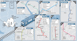
The Maeil Kyeongje's 7 projects (NB our focus below doesn't follow these numbers)

 . Line 1 extension Northwards from Soyosan Station (3 new stations - Choseong-ri, Jeongok, and Yeoncheon): 

Since this extension mostly doubles an existing train, the article logically mentions a low impact on real estate. but it does make commuting more seamless for densely inhabited parts of Yeoncheon-gun, and allows Seoulites to venture further up the Dongducheon valley (not necessarily closer to the DMZ, though: it follows the same axis in this area).

 . Line 4 extension Eastwards from Danggogae Station (3 new stations - Byeollae Byeolgaram, Onam, and Jinjeop):

To be inaugurated next March, this 14.9 km extension is a game changer for this section of Namyangju dotted with major new towns (Byeollae and Jinjeop-eup). But as usual, what a shame that such major clusters were not connected to the grid from day one. 

Of course, this means more commuter traffic for a line already supporting older generation bed towns, but it will also help one of them, Nowon, grow as a cultural hub in Northeast Seoul. Furthermore, the article reminds us of two other projects that will help cope with the flow:

  • Seoul considers doubling Line 4 with an express service for the 31.7 km section within city limits, between Danggogae and Namtaeryeong, with potentially 12 more stations concerned (all the ones connected to other lines). That would leave 12 stations with only the standard service, along with the ones in Gyeonggi-do.
  • The extension of Line 8 Northwards from Amsa Station to Byeollae Station (Gyeongchun Line) by the end of 2023 could later be prolonged to Byeollae Byeolgaram Station via a new station, Byeollae Jungang, further anchoring Byeollae to the South, and making it a transport hub east of Seoul around a decent 'Byeollae Line' backbone.

 . Inauguration of Namwirye Station (Line 8):

Located between Bokjeong and Sanseong Stations in Seongnam, Namwirye doesn't really support Wirye New Town which, as the author mentions, would have much more impact. But he's not taking into account a tramway bound to deliver the goods: the construction of the Wirye Line is just starting these days.

'#Seoul about to start the construction of its first #tramway in decades (#WiryeLine - 12 stations, 5.4 km - to open i 2025). Line announced 8 years ago (http://seoulvillage.blogspot.com/2013/08/seoul-lrt-projects-update-part-22.html) #transports' (20211220 - @theseoulvillage)


 . Gyeongui Jungang Line extension Northeastwards from Imjingang Station to Dorasan Station

In this part of Paju, as the article confirms, 'nothing to do with real estate'. This line is simply inching further towards Kaesong, now a reasonable walk away... provided of course you've got all the papers to enter the DMZ at that most strategic point. For the moment, you're mostly connecting Seoul to a giant, empty parking lot: doesn't look like many workers will commute any time soon to the Kaesong Industrial Complex... Let's hope that some day, this dead end will be prolonged into a friendlier North Korea.


 . Seohae Line extension Northwards from Sosa Station to Wonjong Station (via Bucheon Stadium Station)

As we've already seen (in "Twice upon a time in the West"), there's a lot going on around Bucheon. This vertical will split much earlier the traffic to/from Seoul between the North (Line 1) and the South (Line 7). And it will later be prolonged not only to Gimpo Airport, but also across the river, to Line 3 (Daegok Station, after a stop in Neunggok Station).

If Daegok seems a bit isolated between Goyang's 'old and new' New Towns (Ilsan to the West, Hwajeong to the East), Line 3 leads to more glamorous sites: downtown Seoul and Gangnam. And I wouldn't be surprised to see this new, vertical airport line that will go from Goyang to Hwaseong (for now, Ansan remains the Southern limit) venture further to the North-Northeast and connect to more New Towns.


 . Sillim Line inauguration (from Gwanaksan Station to Saetgang Station)

Thanks to this precious new vertical connected to Line 9 (Saetbang), Line 1 (Daebang), Line 7 (Boramae), Line 2 (Sillim), 'I live in Bongcheon-dong' will sound a lot more uplifting. But in parallel to this LRT,  Western Seoul needs more verticals (Gangnam-gu already getting it's fourth!), starting with Seobu Line...


 . Shinbundang Line Northwards extension from Gangnam Station to Sinsa Station:  

The article made its headline on the star extension because it's about real estate and money, and we're talking expensive real estate (Gangnam-daero), and expensive stations: Gangnam on Line 2, Sinnonhyeon on Line 9, Nonhyeon on Line 7, and Sinsa-dong on Line 3. No new stations, but hopefully fewer cars on the Hannam Bridge once Sinbundang's next profitable extension to the North will lead across the river and Yongsan, all the way to Yongsan Station.

*

Beyond railway and subway projects, Maeil Kyeongje also mentioned work on more sections of the capital region's Second Ring Expressway, which will definitely have some impact. But what the region needs is more public transportation, and a better dialog within Gyeonggi-do, beyond the usual Seoul-suburbs dialog.

It's always good to connect existing dots, and the Ansan-Bucheon-Goyang axis is very welcome, but no new major urban projects should be allowed without a direct connection to the network.

The problem is that Gyeonggi-do is poorly managed, and this has something to do with the way big cities compete with each other without a real regional authority. Only the State has the potential to force some collaboration, or at least more coopetition and less competition within Gyeonggi-do. The lack of political will and strategic vision results in the multiplication of projects cannibalizing each other, a suicidal rat race as the population ages and declines. Clearly, there are countless ways of spending less, better, and still generating much more value for everyone.

 
Seoul Village 2021
Welcome to our Korean Errlines! Follow Seoul Village on Facebook and Twitter, follow me on Instagram.
Download 'Seoul VillageS', the free ebook.
Bookmark and Share

* ""딱 역 3개인데, 폭발력 엄청나다"…판교 분당 부동산 난리난 이유" (Maeil Business Newspaper 20211226)
** see "Seoul subway to gain 89 km by 2025" (June 2015), "Seoul LRT Projects Update (Part 1/2)" and "Seoul LRT Projects Update (Part 2/2)" (August 2013, following "If you ain't broke, fix it: Seoul, Welfare and Railways Deficits" - July 2013). See also all subway related posts.

Friday, September 5, 2014

Freeways as Dividers, Connectors, and Destinations

On Chuseok, I have a special thought for Korea Expressway teams. This is their busiest moment of the year, and they have no time to spend with their families because they want to make sure you do it safely.

Last spring, I visited their facilities in Gungnae-dong, Bundang-gu, Seongnam-si, Gyeonggi-do. A great moment! That's where they monitor the traffic for the whole nation, and where they broadcast 176 updates every day.


And live from Korea expressways main broadcasting station
twitter.com/theseoulvillage/status/482092363821481984
From Korea Expressway's control room
twitter.com/theseoulvillage/status/488670603504005120


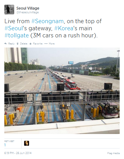
They're also right at Seoul's main gateway. You know how much I love to wander along Seoul alleyways, but I must confess that I enjoyed overlooking tens of lines of traffic from the rooftop of that tollgate:


This four-decade-old structure stretches for 400-500 m over Korea's main backbone: Gyeongbu Expressway, a.k.a. Expressway No. 1. The site reminded me how freeways can be at the same time fantastic connectors, great dividers, and awesome destinations.


*** HIGHWAYS AS CONNECTORS ***


Korean regions are much better interconnected than they were a couple of decades ago, and from 3,762 km in 2013, the national expressway network will grow to 6,160 km by the end of the decade. If the old Seoul-Busan diagonal remains clearly visible, the grid will be more balanced, with 7 North/South and 9 East/West axes. All points on mainland shall be within only 30 mn from an exit.


The network now and tomorrow (Korea Expressway Corporation - ex.co.kr)


When Beijing's building its 7th ring road (940 km), Korea's capital region is still working on its 2nd belt: after the "100", Sudogwon's "400" will connect Incheon, Ansan, Songsan, Bongdam, Osan, Ichon, Gangsang, Yangpyeong, Hwado, Pocheon, Paju, and Gimpo.


*** HIGHWAYS AS DIVIDERS ***


Of course, highways are not necessarily a sign of progress, and many in Korea still believe that adding roads is the only solution to all traffic problems. And even before talking about induced demand: how many times did we see public transportation systems be considered only after the construction of a New Town?

Cities and highways are mutually exclusive, that's why everything must be made to prevent them from meeting. That's also why Los Angeles cannot be considered a city, and Seoul is struggling to survive. And don't try to limit direct contacts at ground level by elevating the roads: it only worsens the situation (see for instance "Along Hongjecheon, my way or the highway").

Beltways that actually relieve urban centers can be a lesser evil, but even they can increase traffic and environmental damage (see for example the not really discreet Incheon-Ansan section of Seoul's second belt in the 2nd part "Connectivity, Continuity and Consistence" of my "Songdo, DMC: sequence is of the essence" trilogy).

Now back to that tollgate and Expressway No. 1. The view below illustrates how that Amazon of concrete divides the landscape even more dramatically than a natural or political border - hard to tell if the odds for a pedestrian to survive a crossing are better than at the DMZ: 


Live from Seongnam, on the top of Seoul's gateway, Korea's main tollgate (3M cars on a rush hour).
twitter.com/theseoulvillage/status/482090698359832576

(NB: West to the right, East to the left)
The contrast is even more spectacular on Google Maps:
  • To the East, Bundang stretches its 'apateu' blocks around Tancheon stream.
  • To the much West, from the green slopes of Gwanggyosan, the narrow valleys of Gungnae-dong and Geumgok-dong join Daewangpangyo-ro, a road parallel to the freeway from Geumgok I.C. (South) to Seoul beltway #100 via Pangyo New Town (North). 
  • In the center, Expressway No. 1 and its tollgate bulge (reminds me of the boa that swallowed an elephant in 'Le Petit Prince'):


The tollgate from above (NB: West to the left, East to the right)

I clearly remember watching, during the nineties, Bundang New Town rise from a sea of cranes, while the suburbs on the Western side remained stuck in time - and the mountains relatively spared.

I also remember wondering why natural embankments were not included in the New Town's original master plan: instead of the usual sinister noise barriers, green slopes would have made that side of the freeway much more pleasant. I knew that it took more space, but when you build a town from scratch, you shouldn't compromise on key elements that impact its sustainability and its perception both from the inside and from the outside...

Pangyo New Town didn't fare much better a couple of years later (see "Pangyo from scratch to crash"): noise barriers? checked - elevated highway? checked... Of course urban planners didn't seize the opportunity to cover a wide section of the highway between Bundang and Pangyo...

But I've already spilled way too much venom on Korea's New Towns here and there, and they're not the topic of the day. Furthermore, 'greenfield new towns' like Bundang now belong to the past (see "New Town out, Redevelopment in, back to the Urban Jungle").


*** HIGHWAYS AS DESTINATIONS ***


Many people see highways as tunnels in time, a moment when life is suspended between a departure and a destination, a lost moment. But the path is a destination in itself, and freeways remain an eternal source of inspiration - beyond the vast 'road movie' culture.

Smooth roads, green rest areas equipped with showers, lounges, and free wi-fi... the freeway experience in Korea has nothing to do with the nightmare of yore, and the people in charge are fully aware of importance of always improving safety and quality, of making the most of existing infrastructures (e.g. solar energy production on abandoned roads). They truly care about - yes - your happiness.

So if you drive during this Chuseok break, even if you are stuck in thick traffic, relax.

And don't hesitate to stretch time. Don't forget to take a break every two hours, the rest areas are also here for that. Why not opt out and back in, seize the opportunity and discover a part of Korea you didn't plan to see?


With my new friend in Gangwon-do. Her potatoes were fantastic, and her joy illuminated our day.
twitter.com/theseoulvillage/status/483117975265087488
(Last June, during a trip in Gangwon-do, we were invited to Gwirae-myeon, Wonju-si. Now bypassed by a bigger road, the village has seen many shops and restaurant close, which gives it a very special atmosphere)


Seoul Village 2014
Welcome to our Korean Errlines! Follow Seoul Village on Facebook and Twitter
Bookmark and Share
Add this page to your favorites


Monday, June 7, 2010

Pangyo from scratch to crash

Picture this : you're given the opportunity to build from scratch a new town in a green valley with the benediction of the State. Not many existing buildings, essentially a mattress of plastic green houses ("vinyl houses" in good Korean).

This time, we can't get it wrong, can we ?

Yes, we can : 20+ storey-buildings ruining the landscape, colorful tubes of elevated roads snakingly copulating in mid-air, probably about to lay eggs for more baby concrete Cheonggyecheons, and even in front of the newly completed town houses, a tall commercial center destroying the only low rise area. Of course, no subway in this section of the new town.

Welcome to Pangyo New Town.

Or rather West Pangyo, because this New Town has been built on both sides of Highway 1 / Gyeongbu Expressway, an urban landmark as graceful and efficient as the Berlin Wall in the late 60s.

Technically, Pangyo New Town is not a new town but a part of Bundang, an Older New Town, but also a 'gu' of Seongnam city. I remember the construction of that area during the 90s, passing by fields of cranes each time I travelled South, watching Bundang rise up like in a Sim City game on steroids. Every now and then I would have a closer look, and one day the great concrete shell became full of people who seemed to have been living there for decades. That was it.

The Westernmost part of Pangyo hasn't reached that stage yet. Many people have already moved in, and the first services are opening, but many lots remain bare and the sales for low rise sections are only starting these days. A few months from now the place will very much more resemble other Korean cityscapes, a bit greener, but with the usual eyesores ruining natural landmarks. Burying the traffic, even by doubling the existing highways before removing them, wouldn't have cost that much more and would have completely changed the whole story. Forever.

Building towers and elevated roads when you have the possibility to avoid them is simply criminal. Building a New Town around them plainly stupid.

Seoul Village 2010

Tuesday, April 13, 2010

FixMyStreet, will you ?

The Fix My Street concept was born in the UK under the mySociety umbrella : volunteer citizens write to their MPs, report problems, and sometimes fix them.

Seoul citizens launched a Korean version of the website : people signal a pothole or a broken sign, and generally within days it's fixed. The concept is very nice and may prevent broken ankles, but there's no guarantee that the result will look good... even if street repairs performed by local administrations don't always look good either.

Something FixMyStreet Korea did really well is their website* and brand : Igeoba ("이거바") stands for Igeorireul bagguja" ("이거리를 바꾸자" - let's change this street) and sounds like Igeobwa ("이거봐"), which means "look !" or "look at this !"

Take this case in 3677 Geumgwang-dong, Jungwon-gu, Seongnam : the picture of a big pothole in the middle of the street, with the map to locate it, were posted on April 8...


And the next day, it's covered (see exhibit B). You can almost wonder if the guy who did it was the very person who posted the case in the first place, or better : the owner of the real estate agency advertised on both pictures...

Personally, I wouldn't encourage this kind of initiatives, except maybe in forsaken places where local authorities say they cannot afford public work. But in any case, it should be done with their approval.

In Seoul, where citizens can easily make themselves heard, there are already hundred ways of contributing to cityscape improvement at the individual level. The positive thing is citizens are more and more taking to heart their environment, and are ready to volunteer for it.

Seoul Village 2010

*
FixMyStreet.kr definitely beats the original (FixMyStreet.com by mysociety.org).

Monday, February 15, 2010

Subway news : Sillim line, Line 3...

Next month, Seoul will decide among the two finalists (NamSeoul Light Rail Ltd and Yeouido Sillim Light Rail Co., Ltd.) the winning consortium for its future Yeouido-Sillim (여의도-신림) Light Rapid Transit line. Construction shall start in 2012 for an inauguration in 2017 and by then, a complete Southwest - Northwest Seoul connection should be operational : other LRT sections are planned between Eunpyeong-gu (ie Eungam-dong) and Yeouido via Seodaemun-gu (ie Yeonhui-dong).

This new line will start from Gwanak-gu and Seoul National University, but at the very gates, not at the existing station. It will follow Dorimcheon, the stream serpenting across Sillim-dong which give the area a unique charm, and head North towards Yeouido (Saetgang Station, Line 9) via Sillim Station (Line 2), Boramae Park (Line 7) and Daebang Station (Railway).


Overall : 7.82 km and 10 stations including 6 brand new ones. That will add some verticality badly needed by a network that's desperately horizontal in this part of the Capital (only Line 4 is heading straigth South, but that's East of Gwanaksan).

If this line makes perfect sense, I'm not sure Sillim-dong can keep the unique charm I mentioned earlier : high buildings are step by step masking the exceptional natural site around Dorimcheon (please preserve the hills !), and a major cluster will bloom along Hoam-gil on the way to Geumcheon-gu : Sillim New Town. I'm sure the place will be much more popular and more fun in 2017, but it probably won't be the same...

More immediate changes ? Line 3 is about to inaugurate 3 new stations this Thursday, February 18th, 2010. Instead of finishing in Gangnam-gu at Suseo Station (Bundang Line), the orange line will cross Songpa-gu (Garak-dong and Ogeum-dong) :
- connection with Line 8 at Garak Market Station
- new station : National Police Hospital
- connection with Line 5 (a line already met at Jongno-3-ga Station) at Ogeum Station

This extention confirms the importance of the Seongnam-Gangnam corridor, but instead of just commuting, why not visit the Garak wholesale market ? Definitely less cute than your local traditional market (except maybe for informal merchants at the entrance), but quite impressive : the merchandise is more often exposed in bulk than packaged, and depending on the season you can see whole hangars filled with onions or watermelons.

That said, yet, what we got here is yet another line stopping short of entering Hanam... Line 9 seems in a better position to do so (via Gambu-dong), unless Line 5 prolongs via Macheon-dong or Mangwol-dong. The other end of Line 3 has a brighter perspective, for beyond Goyang (today's terminus : Daehwa-dong, KINTEX), and towards West Paju.

Seoul Village 2010

Friday, January 29, 2010

Yongsan-Gangnam-Bundang subway completed in 2017

Seoul Village 2010 - Bundang, Gangnam, Yongsan... the New Bundang subway line seems to be going back in time as it links symbols of the 2000s, 1980s, and 1960s. Will it go back all the way to the 1390s and Seoul city center some day ?

In 2017, 7.5 km will be added to the "Sinbundangseon" (신분당선), connecting Gangnam Station with Yongsan Station. The inauguration of the first section (17.3 km from Jeongja Station in Seongnam, Gyeonggi-do to Gangnam Station) was postponed from July 2010 to September 2011.

Joining Bundang business district and Pangyo New Town directly with the Northern half of the capital city is already an important step, but extensions all the way up to Gwanghwamun and Gyeongbokgung stations were also considered at one stage (POSCO plan).

Yesterday, the government already announced a total of KRW 18.6 for railways, ports, and logistics, plus 22.9 tn for roads. The Sin Bundang extension is expected to cost W 900 bn excluding expropriations, and for the moment it is supposed to cross the Yongsan Army Base... which means delays and additional costs are more than likely.

Section to be inaugurated next year (3.2 + 8 + 2.9 + 1.7 + 1.5 = 17.3 km) :

. Jeongja station (connected with Bundang Line)
. Pangyo station (new station, future Yeoju Line, heading for Southeastern Gyeonggi-do)
. Cheonggye / Cheonggyesan station (new station)
. Yangjae Citizen's Forest / Maeheon (new station)
. Yangjae station / Seocho-gu Office (subway Line 3)
. Gangnam station (subway Line 2)

Extension decided yesterday (7.5 km) :

. SinNonhyeon (subway Line 9) - to be confirmed
. Nonhyeon (subway Line 7)
. Sinsa (subway Line 3)
. Seobinggo (station of the Yongsan-Deokso section of the old Jungang Line)
. Ichon Station / National Museum (subway Line 4, Yongsan-Deokso)
. Yongsan Station (subway Line 1, KTX bullet train, Yongsan-Deokso)

Thursday, September 3, 2009

Gwangju completes the Seongnam-Hanam merger

It didn't take too long for Gwangju to join the Seongnam - Hanam party (see "Seongnam and Hanam merge").

For the missing and central piece of the puzzle, it was only a matter of "when"... and "how" to justify the flip-flop.

Officially, Gwangju authorities refused in the first place for a lack of consensus at the national level, but the Ministry of Public Administration and Security almost begged them to change their minds. And now, the former capital is eager to push for the merger, even initiating a poll for as early as this month.

Whatever... Seoul has now a significant giant at its doors :
as we saw earlier, Gwangju + Seongnam + Hanam is as big as Seoul, claims about 1.3 M souls, and boasts major IT and cultural centers.

Bonus : now, the green spaces at the frontier between Seongnam and Hanam will not necessarily be destroyed.

Tuesday, August 18, 2009

Seongnam and Hanam merge

The cities of Seongnam and Hanam (both in Gyeonggi-do) announced their intention to merge by 2014 in a new city which would border Southeast Seoul from Gangdong-gu to Gangnam-gu via Songpa-gu.

In such mergers, more ambitious and harmonious policies can be developped, and the new ensemble can forge a stronger identity, be more competitive at the national and international level. But the union has to be carefully and soundly planned, and it is essential to preserve the soul of each area of the newly formed city. Spotting and reviving key cultural assets should even be considered an essential mission. So I would strongly advise planners to make a lot of research back in time before starting anything irreversible. This is clearly a promise for the future and a new start, but certainly not from scratch, from a blank page.

And I hope this won't end up in more destruction of Seoul's vital greenbelts.


A FORESEEABLE TREND

A referendum involving Seongnam and Hanam citizens shall be held, but the final decision remain in the hands of the national government... which shouldn't oppose the move : LEE Myung-bak wants to regroup 246 administrative areas into 60 to 70 municipalities, a natural trend that Japan has been experiencing for years, and that Nicolas Sarkozy is also considering for Paris' "little belt".

Among other regroupments under discussion within Gyeonggi-do : Guri with Namyangju (an obvious team just booming, just North of Seongnam-Hanam, on the other side of the Han river), and Hwaseong with Suwon (a powerful economic - cultural combo south, which could counterbalance the impressive rise of nearby Incheon).

I don't see small and unpopulated cities like Gwacheon (35.9 km2 / 74,600 inh.) or Uiwang (53 / 142,000) remain much longer on their own : a merger with Anyang (58 / 618,000) could be a solution. Gimpo seems big enough, but not so dense (276.6 km2 / 203,000), but many areas are either booming or about to (ie near Incheon's Cheongna, Ganghwa-do). Bucheon or Gwangmyeong are populated (850,000 and 341,000) but small (53.4 and 38.5 km2). For this pair, joining forces with Siheung (441,000 / 131) and why not even Ansan (Southwards) would make sense... Combinations are countless.


GWANGJU OUT OF THE LOOP... FOR THE MOMENT

Seongnam-Hanam project started as an even more ambitious project : Gwangju (the Gyeonggi-do city not to be confused with South West Korea's metro city) was initally in the loop and eventually declined to join Seongnam and Hanam, which would have created a major and relevant powerhouse :

- Today, Seongnam claims 141.8 square kilometers and 1,023,000 inhabitants (including people about to move in Pangyo New Town). Hanam 93 and 128,000. The 235 km2 and 1,13 million inhabitants ensemble will claim the "Metropolitan City" status and can even beat Suwon (121 km2, 1,087,000 inhabitants) as Gyeonggi-do's most populated city, but Gwangju would add 431 km2 and 215,000 inhabitants, forming a 3-city bigger than Seoul itself (605 km2 - but over 10 M souls).

- From a geographical point of view, Seongnam-Hanam looks a bit crooked : only a tiny kilometer of common border (at Hanam's Hakam-dong) unites two otherwise distant blocks and furthermore, a mountain (Namhansan) prevents both urban centers from actually connecting. Gwangju is the obvious missing piece that would complete a puzzle as harmoniously* shaped as the capital Seoul.

- Precisely, Gwangju used to be a capital, and the 3-city-merger would have made perfect sense at the historical level. The young city of Hanam (established on January 1st, 1989) owes its name to the former capital of Baekjae Kingdom, and used to belong to Gwangju-gun. Besides, the Gwangju corner that fills the puzzle, the fortress of Namhansanseong, would be the trio's perfect pivotal landmark.

Joining the duo later may prove more difficult...


A STIMULATING URBAN CHALLENGE

This administrative measure will necessarily have more or less telluric effects. Typically, the old core of Seongnam city, sidelined by Bundang and Pangyo, appears now central and is very much likely to experience some kind of revival.

Today, Seongnam-Hanam looks as unbalanced as Incheon, with very various landscapes, from the Southwestern New Towns to the Northeastern nature (Hangang, Geomdansan). And each block is disfigured by a major highway hub : Pangyo InterChange (Highway 1 to Busan / Circular 100) for Seongnam, Hanam Junction for Hanam (100 with Highway 35 to Daejeon).

Bundang lost some of its luster but remains a success story. Yet competition is raging with cities further south. Cities which don't have as many natural obstacles to development.

I'm sure city planners are full of ideas. But I hope destroying Namhansan is not one of them. Seoul green belts are definitely in real danger these days.

Seoul Village 2009

* from a distance at least, because each city lies in a different valley and connecting the centers would somehow mean replacing mountains with concrete.