NEW - download 'Seoul VillageS (서울 마을들)', my collection of 12 short fictions now adapted into short films! Get your free copy of the ebook (4 editions: English, French, Korean, Bilingual English-Korean)!

Showing posts with label Yulgok-ro. Show all posts

Wednesday, January 26, 2022

More Gwanghwamun Square previews

Seoul revealed new visuals of Gwanghwamun Square 3.0, which shall be inaugurated in July.
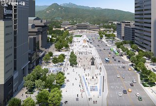
They prolong the last major iteration presented in 2019 ("Gwanghwamun Square 3.0 re-Deep-Surfaces"), which corrected one of the worst urbanistic blunders  of the initial version ("Gwanghwamun Square Enters Third Dimension"). PARK Won-soon's team rushed the construction a few months before the elections without conducting any decent impact survey, and work started late 2020. As soon as OH Se-hoon returned as mayor, he paused the site to assess the situation, but the changes could only be cosmetic.

The Woldae extension in front of the palace gate will only be created next year, so we have yet to see how vehicles flow around Yulgok-ro's future curve. Adjusting to the modifications already in place is not always easy. As expected, the intersection in front of Sajik-dan helps reconnect both sides of Sajik-dong, but the impossible new U-turn just North of the Government building stops functioning as soon as traffic slows down (too close before a major traffic light, unlike the old one heading for Sajik tunnel).

Most important, Seoul's defining axis is preserved, with its iconic Gwanghwamun-Gyeongbokgung-Bugaksan perspective, and pedestrians will enjoy a 20 m-wide park with a vast selection of tree species, guaranteeing natural shade and oxygen as they grow. That's where most of the extension (from 18 to 40,000 square meters) comes from. People will be able to sit on benches and along the Haechi Madang ramp, where street animations may bloom next to the new media wall.

Sejong-daero's pedestrian and cycling experience has already been improved with the new green walks and bike lanes added on the way to Namdaemun (see "Lower Sejongdaero's turn"). With its fountain tunnel and pavement fountain, the 'Gwanghwamun' Lounge section is likely to welcome kids and keep them fresh during the Summer. If some artifacts found during the renovation shall be on display in the cultural section, most of the Joseon era infrastructures (see timeline*) shall be covered again. I hope the tribute to Yukjo street will not look to corny. 


On the Eastern side, Junghak-dong will not host a simple reconstitution of the old Uijeongbu site, but a fusion hanok exhibition space. I wish there were more trees in that section, but that can (and probably will, if they want the spot to be successful) be fixed later.

This Uijeongbu project was on display at the Seoul Hall Of Urbanism (see again timeline below*) during the low key, pandemic-plagued 3rd edition of the Seoul Biennale of Architecture and Urbanism. SBAU will return in September 2023, with CHO Byung-soo (BCHO Architects) as its Director. This architects knows a bit about dao, and Seoul could do with some more harmony...

Ganghwamun Square reopening in the heat of the Summer will be a perfect crash test. I'm pretty sure Seoulites will quickly make it their own. At least during the evenings. And as much as that damned coronavirus will allow.


Seoul Village 2022
Welcome to our Korean Errlines! Follow Seoul Village on Facebook and Twitter, follow me on Instagram.
Download 'Seoul VillageS', the free ebook.
Bookmark and Share


* From @theSeoulVillage timeline: 


"Gwanghwamun Square last week. Seoul started controversial revamping without a proper impact survey..." (20201220 - twitter.com/theseoulvillage/status/1336888158437265408)


"The few changes since the initial plan won't prevent the expected traffic pandemonium. Tragic lack of urban planning, urbanism vision from Seoul... Sejong-daero Gwanghwamun" (20210221 - twitter.com/theseoulvillage/status/1364019424752115720)


"Western side of Sejong-daero / Gwanghwamun Square to close tomorrow for the controversial revamping (future Jeokseon-dong loop in the foreground)" (20210305 - twitter.com/theseoulvillage/status/1367760419218018306)

"As expected, works on the Western side of Gwanghwamun Square for its extension reveal Joseon time artifacts and structures related to former ministries. Here, a waterway in Jeokseon-dong (between Baekundongcheon & Junghakcheon - see seoulvillage.blogspot.com/2009/08/baekun #urbanism)." (20210319 - twitter.com/theseoulvillage/status/1372721209939431427)

"I guess mainly to evacuate overflows towards Baekundongcheon, to contain water damage in case of heavy rains. Gwanghwamun Square urbanism Jeokseon-dong Photo Chosun Ilbo" (20210319 - twitter.com/theseoulvillage/status/1372721211789037583)
"OH Se-hoon hits pause button on controversial Gwanghwamun Square revamping. Also asks AHN Cheol-soo to suggest talents for Seoul." (20210410 - twitter.com/theseoulvillage/status/1380664510638264322)


"Seoul's unearthed Yukjogeori during Gwanghwamun Square revamping:" (20210511 - twitter.com/theseoulvillage/status/1391895161337090049)


"Gwanghwamun's future Uijeongbu site at Seoul HOUR (Seoul Biennale / SBAU):" (20211028 - twitter.com/theseoulvillage/status/1453500318226935809)


Thursday, October 23, 2014

Gwanghwamun, Donhwamun, and the Tale of two Royal Roads

Seoul is about to renovate the two streets leading to its main royal gates: Sejong-daero (Gwanghwamun, Gyeongbokgung's gate) and Donhwamun-ro (Donhwamun, Changdeokgung's gate). Needless to say, these are key locations, and authorities have to make sure that they do it right, and that to start with, there is a consistent and sustainable vision for Seoul's future.


*
In the case of Sejong-daero, the idea is to attach Gwanghwamun Square to the Western side, which somehow means a return to the initial plan of a wider area in front of the Sejong Cultural Center. The main motivation seems to be money: the massive foot traffic on the square would generate much more revenue there. Why not indeed? Let's see what it means when you consider the two most likely scenarii:
  • If the plaza is extended westwards: 6 lanes of traffic will disappear, and I'm perfectly okay with that, but only if all impacts are taken into account, and I'm not sure that's the case. To be consistent, Seoul authorities must have a clear strategy to reduce car traffic downtown - like most major cities. Unfortunately, several projects (e.g. from Jahamun to the Yulgok Tunnel) seem bound to generate more bottlenecks in a near future.
  • If a new plaza is built to the west instead of the central one: we are back to square(!) one and a huge highway in the middle of the city - 12 lanes of traffic! It would destroy not only Seoul's most valuable perspective (Sejongdaero-Gwanghwamun-Gyeongbokgung-Bugaksan-Bukhansan), but also Seoul's most vital pedestrian connector downtown (see links at the end of this post).
(addendum 20141025) Rendering of the project where the Gwanghwamun Plaza is moved westwards, recreating the central highway that used to ruin downtown Seoul (source "광화문광장, 세종문화회관 쪽으로 이전 추진" (Hankyoreh 20140930). A total urban disaster, but maybe the actual aim of the game is to prevent demonstrations, the only case where it would make sense (much easier to close the area with much fewer troops).
I'm against the plan to move Gwanghwamun Plaza next to Sejong Center: makes more money, but destroys royal perspective + cars rule again - 20141011 twitter.com/theseoulvillage/status/520781390309126144


*

In the case of Donhwamun-ro, the idea is to boost tourism in a major but under-exploited historic neighborhood. A couple of years ago, I applauded the planned destruction of the two gas stations that faced the gate, but also shared concerns about the impacts of the Yulgok Tunnel on area. In this case, I'm at the same time glad that, at long last, the Changdeokgung-Jongmyo axis is considered as a key asset, and very much worried about how the whole project could backfire if handled carelessly: this is typically one of these time capsules you want to deal with carefully. How to revive the area without 'bukchonizing' it, without creating an artificial touristic hotspot and worse, a short-lived speculation heaven?

This area has already significantly evolved over the past decade. Here are the neighborhoods directly concerned:
  • At the center, covering Donhwamun-ro itself: Waryong-dong and Myo-dong (the former also includes large sections of the palace, and even a part of Jongmyo - otherwise mostly in the Hunjeong-dong sphere). 
  • To the north: Wonseo-dong and the Palace
  • To the west, towards Unhyeongung and Insa-dong: Unni-dong, Nagwon-dong, Donui-dong, and the already endangered Ikseon-dong.
  • To the east, towards Jongmyo: Gwonnon-dong, Bongik-dong
  • To the south: Jongno-3-ga and Cheonggyecheon
Let's see this new project* in details:
  • Where the gas stations used to be, an exhibition hall for traditional culture and a Gugak Arts Center will be constructed, creating a hanokish triangle with the gate. How to feed these cultural venues without depriving existing structures remains to be seen, but it's clearly a much more UNESCO-friendly scenery than the love motels behind.
  • The 600 m stretch between Donhwamun and Cheonggyecheon will be "reconstructed", and I'm afraid this street could lose its vintage charm. This is a perfectly proportioned street lined with old trees, so please don't try to 'reconstruct' it. You wouldn't want to ruin everything the Jogyesa-way (its streetside now a sanitized disneyland), or even the Jeongdong-gil-way (see the "Jeongdong-kill" asphalt mess). On the positive side, Donhwamun-ro could become pedestrian, like Yonsei-ro**. 

Seoul should remember that it put the restoration of its fortress on hold because the UNESCO didn't think that it hadn't been done properly until then... the priority here is to secure the area from speculative alterations.


Joseon Seoul: in today's KJD, more on the restoraion of Donhwamun Royal Road - 20141023 twitter.com/theseoulvillage/status/525086786767179776
Bonus: it would be nice to avoid the usual touristic fakes. I'm shivering just thinking about yet another embarrassing costumed reenactment. You know, after the changing of the guards at Deoksugung or Gyeongbokgung, something like 'watch the King perform his royal walk along the royal road'?

That's okay if you want to entertain duty-free shoppers on Incheon Airport's Airstar Avenue, but don't you think Changdeokgung and Jongmyo deserve something better?


*

See also:

Seoul Village 2014
Welcome to our Korean Errlines! Follow Seoul Village on Facebook and Twitter
Bookmark and Share
Add this page to your favorites


* "Royal road in Seoul will be restored" (Korea JoongAng Daily 2014/10/23)
** see "Yonsei-ro the first street in Seoul to ban cars in its transportation mix"

---UPDATE 20141025---
I added an illustration of the future Gwanghwamun Plaza, which clearly shows the return to a central highway.

Sunday, July 28, 2013

MMCA Seoul from above

The recently rebranded National Museum of Modern and Contemporary Art, Korea unveiled this video of the MMCA Seoul branch to be inaugurated this November (see "MOCA goes MMCA - Museum of Modern and Contemporary Art"):


I like the vivid rendering of the neighborhood:
  • starting northwards, along Samcheong-ro: to the left the Gyeongbokgung, to the right Sogyeok-dong galleries and the new museum, with in the distance Bugaksan

  • the virtual camera turns to the right and the former DSC's main building, which shed its white coating to bare its red bricks - and still those wonderful semicircular staircases I caught by night under last month's Supermoon:

@theseoulvillage tweet 20130622
"Supermoon" over the future #MMCASeoul
twitter.com/theseoulvillage/status/348434489560686593

ASYAAF 2009 @ DSC - Copyright Stephane MOT 2009
Very spectacular from the inside as well. I took this picture during the 2009 ASYAAF (NB: don't forget: this year's edition is back to Culture Station Seoul 284 - until August 18 for the second part)


  • about halfway into the video, we're slowing down before the next building, to enjoy the now cleared view on the large hanok in the background.

  • we then start taking off slowly to appreciate the renovations and extensions, the gardens and green rooftops, and a well located terrasse at the corner with Bukchon-ro 5-gil

  • before fading away to make room for the MMCA logo, the whole block is visible (Yulgok-ro to the South, Gamgodang-gil to the East, Samcheong-ro to the West, Bukchon-ro 5-gil to the North)
I won't say that I'm thrilled by the architecture, which reminds me a bit of my old ESSEC Campus (vintage 1973) before its renovation, but this project does mark an improvement for the neighborhood. At least if you compare it to the past (a low-rise open space replacing the gated Defense Security Command), or to Yongsan's criminal NMK (yes I love the National Museum of Korea, but from the outside doesn't it look like a ceausescuesque cinder block?).

Anyway, we shall judge MMCA Seoul from the inside, with all its hidden levels and services, and of course fully populated with collections, exhibitions, and humans.

I can't wait!


Seoul Village 2013
Welcome to our Korean Errlines! Follow Seoul Village on Facebook and Twitter
Bookmark and Share
Add this page to your favorites

Thursday, March 22, 2012

Yulgokno Tunnel

I took these two grainy pictures with my dumbphone, and didn't need Instagram to give them a sepia look: if GCS Int'l enjoy a fantastic view on downtown Seoul, and if they know how to host a seminar*, their windows need some washing.

That's what I call a minor room for improvement.

The problem is when 'improvement' takes too much room, like when the city renovates one of its most strategic boulevards, Yulgokno. Here I'm recycling the ugly sketch I drew for my focus on "Inwangsan's Great Wall and Seoul's Royal "T" Time":


Just to help you locate GCS HQs on Yulgokno, this is their Northern view, from Gwonnong-dong: a section of Changdeokgung (east of Donhwamun, the palace's main gate), Bugaksan in the distance (the mountain), and the hills of Wonseo-dong in-between (Bukchon area, close to Gahoe-dong in the sketch).

Now next slide, please:

Here's a Northeastern view with the four lanes of Yulgokno heading for Wonnam-dong Sageori. You can make out the small footbridge connecting Jongmyo (right) with Changgyeonggung-Changdeokgung Palaces (left), and the working site with its sign advertising the "improvement of Yulgokno in front of Changdeokgung".

From the start*, I applauded the project to reunite Jongmyo and Changdeokgung by covering a section of Yulgokno, but also wondered how the city would manage two more lanes of traffic, and if all impacts were carefully considered (cultural heritage, environment, bicycles, pedestrians...).

Judging by this shot, we're at the stage where asphalt gains over green: the old and peaceful woods of Jongmyo have already shrunk to make room for two more lanes, or at least to divert the traffic during the process.

The doubts remain: I wouldn't want this section of Yulgokno to become yet another dark tunnel, yet another repellent for humans and cyclists, yet another neighborhood sacrificed to Car Almighty. What would be the point of reconnecting North with South while disconnecting East from West?

So let's keep an eye on this one. And if needed, let's summon the ghosts of Sulla-gil. Anyway, they too are watching. Yes, that's Seo Sulla-gil, the street starting right at the working site's gate. And if you want to learn more about that haunted 'patrol way', meet "Jongmyo Ghosts".

Seoul Village 2012
NEW : follow Seoul Village on Facebook and Twitter

* the Asia Institute seminar on North Korean nuclear power (see "NK and nukes: back to the (dolsot curling) stone age?")
**see "Jongno-gu renovation (continued)", following "Jongmyo-Changdeokgung reunited"

Monday, September 6, 2010

Insadong - Bukchon seamless for pedestrians

We're regularly stressing the growing importance of the Northern side of Anguk area as a tourist destination opposite Insadong : already a major cluster of art galleries on the way to Samcheong-dong and Bukchon area), it will host a key museum (the MOCA's Seoul branch), and a 7 star hotel is even considered*.

Yet the connection is not so seamless for pedestrians : the crossing between Insadong-gil and the police station is unconvenient and as saturated as Omotesanto on week-ends. Furthermore, more lanes will be created because of the Yulgokno tunnel**. Nowadays, most tourists head South towards Insadong, but the traffic is becoming more balanced and that trend is bound to be confirmed in the future.

Jongno-gu just decided to tackle the issue :
- prolongation of Insadong car-free axis : the diagonal will continue North of Yulgokno along Gyoyuk-gil (the narrow street bordered with schools) until Bukchon-gil (ArSonje corner). The street itself will be repaved on both sides to reinforce continuity
- connection of this axis with Samcheongdong-gil (Bukchon-gil's section West of ArSonje crossroads).
- creation of a new crosswalk at Yulgokno between Insadong and Gyoyuk-gil

Step by step, the heart of Seoul is definitely becoming more pedestrian friendly.

Seoul Village 2010

* see "
http://seoulvillage.blogspot.com/2010/02/moca-defense-security-command-continued.html" and "Korean Air Grounded : Seoul 7 Star Hotel Delayed"
** see "
Jongno-gu renovation - continued"

Tuesday, July 6, 2010

Changdeokgung : from station to station to ashes to ashes

The other day*, I was not fully convinced by the final project of tunnel between Jongmyo and Changdeokgung : once more, priority was given to cars over public transports, pedestrians and bicycles. And instead of bringing two areas closer, it's as if a new mountain were erected to pull them further apart...

But yesterday, I was pleased to learn that, on the Western side of the tunnel, both gas stations facing Donhwamun (Changdeok Palace main gate) would be removed : until then, only one of the two (I didn't know which one - in Gwanhun-dong / West) or Unni-dong / East) was planned for destruction.

I already voiced my outrage to see the main entrance to a UNESCO World Heritage, Changdeokgung, be disgraced by those gas stations, but I was confident change would come : Jongno-gu intends to extend Insadong tourist area towards Jongmyo, reviving Donhwamun-gil and Sulla-gil on the way. And indeed, the place has dramatically evolved over the past few years, not always for the better : anticipating conservation laws, many Hanok owners replaced their traditional houses with modern structures more fit (to their eyes only of course) for business, ruining the atmosphere.

So it's decided now : the two gas stations will be destroyed in 2012, and the following year two new buildings will be inaugurated : a Royal Life History Digital Gallery (궁중생활사 디지털전시관), and a Traditional Art Hall (돈화문 국악예술당), likely to lure many tourists this side of Yulgokno. I hope the architecture will be more responsible and sustainable than recent tourist traps but anyway, it'll beat oil spills.

Seoul Village 2010

* see "
Jongno-gu renovation - continued"

Saturday, June 26, 2010

Jongno-gu renovation (continued)

Seoul is a permanent working site and even downtown, countless buildings are under construction. Some positive work is also under way for the preservation of Jongno heritages and even if I've been watching them every day it's hard to keep track of everything. A few updates :

- Gwanghwamun : after spreading its wings (lateral walls) over the past few weeks, the gate has just grown feathers (splendid dark tiles) and shedding duvet (the multicolor silhouette of Gwanghwamun was removed from the metal structure covering the renovation site). Inauguration day is definitely approaching, and I'm quite excited : I was glad to see the old Japanese government building disappear, and I can't wait to see the royal Sejongno-Gwanghwamun-Bugaksan-Bukansan perspective fully restored.

- To the East - Yulgokno tunnel (see "
Jongmyo-Changdeokgung reunited") : here is what the 275 m long structure will look like around Donhwamun - Wonnam-dong. Constructors are being selected until September, work will start in October, and inauguration is scheduled for EOY 2012. As I mentioned before, I very much like the ideas of reconnecting Changdeok palace with Jongmyo, and of burying traffic underground, but the cultural alibi doesn't excuse the 50% increase in traffic (from 4 to 6 lanes, even if - or so do I hope at least - two are reserved for buses and public transportation). Traffic must be diverted from downtown instead of increased, and what Seoul needs is an underground circular bypass to aleviate traffic (ie beween East, Northeast, West, Northwest, without passing by city center). Furthermore, this is not a tunnel but a hill built over a road, with the risk of pulling further apart two neighborhoods.

- To the West - sidewalk renovations West of Gwanghwamun towards Sajik-dan (see "
Sajik-dan enshrined, Naeja-dong revived ?") are well advanced now on both sides of Sajikno, and the Gyeongbokgung Station exits far more welcoming. Note that Seoul is getting serious about the look of its streets : you've already noticed the nice grey booths for street vendors, and the elegant black signs mentioning touristic landmarks. Jongno-gu voted stricter guidelines for outdoor advertising, particularly on commercial buildings. This revolution will not happen overnight, but change seems on the way.

- To the South : Junghakcheon restoration (see "Pimatgol, a streamlet runs through it") is advancing as well in a post-war landscape : many buildings have been removed around Gwanghwamun Square and Jongro, most lately on Doryeom-dong-gil, where I wouldn't be surprised to see archeologists find interesting vestiges under the rubbles from very ugly commercial buildings from the late 60s - early 70s. The atmosphere is really strange, particularly in Cheongjin-dong (former Pimatgol and future KT headquarters). On Shinmunro, two new pedestrian crossings have been created. One goes from the Seoul Museum of History to the new building about to be completed next to Citibank. Between both buildings, the Russian Legation (previously hidden by nondescript horrors) is now clearly visible to all visitors to the museum or to Gyeonghui Palace. The other pedestrian crossing is next to the Gangbuk Samsung Hospital, surprisingly close to the existing crossing joining Jeongdong... but not that surprising if you remember that other renovation project : Donuimun gate should be reconstructed precisely between both pedestrian crossings (see "
Donuimun restoration and Sadaemun resurrection")... so I guess construction could be starting pretty soon.Seoul Village 2010

Friday, April 2, 2010

Sajik-dan enshrined, Naeja-dong revived ?

Scaffolding off, Sajik Park exposes its newly restored wall : the traditional stone, wood, and tile construction protects Sajik-dan more efficiently and elegantly than the awful iron fence that used to welcome visitors to that prestigious shrine, the pendant to Jongmyo West of Gyeongbokgung*.

Now Hongsalmun looks again like a gate and not just an isolated monument. And the rites performed in Sajik-dan move closer to their recognition as a UNESCO World Heritage.

This restoration also paves the way for the great Jongno-gu project to redesign the historic Yulgokno-Sajikno axis. I guess it will include traffic lights with pedestrian crossings somewhere between Medong-gil / Pilundae-gil and Naejadong-gil, as well as (speaking of paving the way) decent sidewalks on both sides of Sajikno along Naeja-dong : removing the overpass was a nice first step, but you get tired of potholes.

The Southern half of Naeja-dong is about to change too, and I hope for the better. A first meeting was held last month between residents and local authorities, generally the initial stage for redevelopment, but new regulations also confirmed the protection of hanoks and this area has quite a few to save. The Western part is occupied by the massive headquarters of Seoul Metropolitan Police and at the other end there's a big officetel (Blois), a church, and a collection of medium-sized buildings. In between, an intricate network of small streets full of hanoks, most of them restaurants, marked by Jangchunggo-gil : the only street cutting fully the block between Sajikno and Naejadong-gil is slightly curvy and hilly, and most houses on the Eastern side are traditional ones, which gives it an interesting charm and potential. I often wonder how it would look if both sides were "rehanokized". It would not only save the existing cluster, but also create a very interesting touristic and gastronomic spot opposite Chebu-dong and on the way to Sajik-dan or Sungok Art Museum.

Furthermore, it would also make sense from an historical point of view : this is precisely the place where all the catering was prepared for festivities at the Gyeonbokgung, between the palace and the shrine celebrating harvests and food.


Seoul Village 2010

* "Inwangsan's Great Wall and Seoul's Royal "T" Time". We already mentioned the restoration of this wall (see "The Sandwich").

see other Seochon related posts, including "Baekundongcheon / Gwanghwamun-gil - A River Runs Through It"

Wednesday, March 31, 2010

Korean Air Grounded : Seoul 7 Star Hotel Delayed

Yesterday, education authorities blocked a Korean Air project to build the country's first seven-star hotel just meters away from Gyeongbokgung and Insadong.

KAL got all the agreements for a complex which would definitely have redefined hospitality in this major touristic and cultural area : a hanok-style boutique hotel with luxury shops and exhibition facilities.

It would have been erected at the intersection between Yulgokno and Gyoyuk-gil, a narrow street leading to Jeongdok Public Library, surrounded by schools which, according to the authorities, would have been disturbed. Thus this last moment interdiction.

KAL withdrew its project for the moment, but keeps pushing for it, promising a participation in intensive archeological research : the area must be worth digging... and needless to say, the project is a potential gold mine for the company.

This site belongs to the US Embassy : about twenty grey-green houses and facilities protected with stone walls and a secured black metal gate. Size ? Judging by the map, around 30,000 square meters if you add 49-1 Seonghyeon-dong (20,203.2 sqm according to Korea Land Information System), 97-2 Sagan-dong (6,165.1 sqm), and half of 34 Seonghyeon-dong (6,229.3 sqm - shared with Deokseong Women's Middle School). The first two lots were estimated around KRW 4 M / sqm last year, the latter KRW 3 M / sqm, but for a land this big in such a location the bill must be much higher than USD 100 M. Last year, land was estimated 2.5 times higher just across Yulgokno, but a chaebol paid much more to plant its new headquarters.

I won't judge a concept I haven't seen, but I'm glad this one is based on Korean traditional architecture - I guess it wouldn't have go this far otherwise. What I'm really curious to see are the next steps.

The US Embassy is supposed to move to Yongsan during this decade, Yongsan Army Base to be turned into a huge park, and speculators to make a few dimes in the process. Beyond Songhyeon-dong facilities, what will happen to the main building, in the dead middle of Sejongno ? I wouldn't bet a buck on its "hanokization".

Seoul Village 2010

Friday, November 20, 2009

2 more tunnels up North

If you look at a map, you can't help but notice how Bukhansan cuts in two the Northern part of Seoul. The need to rethink the whole transportation system is becoming everyday more obvious, with a double boom in the Nortwestern (ie Eunpyeong New Town) and Northeastern (ie Uijeongbu / Nowon-gu / Mia-Gireum New Town...) halves.

Two more tunnels will be dug into Bukhansan by 2013, but they look like quick fixes likely to worsen the situation. And there doesn't seem to be any long term vision, any big picture.

Basically, I often compare Bukhansan with an ocean consisting of 3 parts :
=> the main green body : Bukhansan mountain itself, mostly inhabited except for the national park and temples. Seoul claims only the Southwestern half of this block, the rest being split between Uijeongbu, Yangju, and Goyang.

=> Pyeongchang-dong "island" : a valley essentially connected with the rest of the city via artificial tunnels, serpentine paths in the mountains, and the Hongjaecheon streamlet (along Segeomjeong-gil, towards Seodaemun-gu). Actually, the "sea" of Bukhan mountain stops at the Northern shore of this island : mount Bugak claims East and South, and mount Inwang closes the circle (Inwangsan Strait ?). Two "peninsulas" almost reach this island : Seongbuk-dong and Hongeun-dong, respectively from the East and from the West.

=> elsewhere, "Bukhansan ocean shores" are by no means straight lines. They also include smaller "presque-isles" (such as Ui-dong in Dobong-gu). Bukhansan buttresses push further southwards, adding complexity to the landscape (ie the Ansan "lake" beyond Inwangsan to the West, Naksan to the East).

No subway line crosses this ocean. There is an old railway running just North of the mountain in Yangju (Seoul suburban line - 서울교외선 - was built in the early 60s), but nothing until you reach Subway line 3, over 15 km below. Yeongchang inhabitants rely only on unprotected bus lines for public transportation.

Namsan also needs some fixing but there, the equation looks much more simple : considerably smaller, but also more central after Hanyang grew into Seoul (absorbing Yongsan in the process), that mountain is relatively well covered and criscrossed by several tunnels providing direct connections with the South of Han river (via Hannam Bridge, Banpo Bridge...). In 2000-2001, Subway line 6 filled a major gap in the city map by wrapping the Southern side of the mountain.

Over the past 40 years, the only strategy for Bukhansan area has been digging tunnels for cars :

- First came the Sajik Tunnel, in May 1967. Seoul's first tunnel ever prolonged the Royal T* towards Seodaemun and solved part of the Inwangsan problem. It was upgraded in 1980, one year after the completion of Geumhwa Tunnel. Cutting through mount Ansan, that one prolonged the road to Yonsei University.

- Samcheong Tunnel was completed in December 1970, connecting Samcheong-dong (Jongno-gu) with Seongbuk-dong (then Dongdaemun-gu, now Seongbuk-gu). But it must have been the other way round : the elite living in Seongbuk-dong heights obviously needed a shortcut to join downtown and the center of power without passing by Hyehwa rotary.

- A few months later (August 1971), the much longer Bugak Tunnel connected Pyeongchang island / valley with Jeongneung-dong, Seongbuk-gu. On the other side of this tunnel upgraded in December 1991, Segeomjeong-gil, Pyeonchang-dong's main road, becomes Jeongneung-gil, which leads to the main N/S axis East of Bukhansan : Dongsomunno, named Miaro here and Dobongno upper to the North.

- In December 1980, Gugi Tunnel completed Bukhansan's first East-West axis as it made the junction between Eunpyeong-gu (Bulgwang-dong) and "Pyeongchang island" (Gugi-dong) : now Jiheungno road goes all the way from the same Segeomjeong-gil to Dongilro, the biggest road West of Bukhansan, which becomes Euijuro as it nears city center.

- In August 1986, Jahamun Tunnel doubled the link between the island and downtown, this time West of the Gyeongbokgung, between Cheongun-dong and Buam-dong and next to the old gate. Pyeongchang island appears now more clearly as a part of Jongno-gu. But even if it's much bigger than Samcheongdong-gil, Jahamun-gil is already pouring too much traffic into Gwanghwamun Station area... and one of the new tunnels will bring even more cars there...

- A second West-East axis was built in 1999, this time without any stop in Pyeongchang : the Naebu Expressway (내부순환고속도로) simply crosses this area from Hongeun-dong, Seodaemun-gu to Jeongneung-dong, right below the Bugak Tunnel exit. Most of the journey is in Hongjimun Tunnel and Jeongneung Tunnel, with just, between them, a short outdoor section overlooking the Hongjaecheon streamlet in Pyeongchang-dong (no exit, no entry).

- Sapaesan Tunnel was inaugurated in December 2007 with the Uijeongbu-Songchu / Ilsan section of the Seoul Ring Expressway (서울외곽순환고속도로, also known as Expressway 100 or Seoul Beltway). This 4 km long hole in the Northest part of Bukhansan (not even in Seoul city) was postponed after fierce resistance from local monks who wanted to preserve the soul of the mountain.

So what we have right now is basically a square covering one tenth of Seoul superficies but totally void of subway, and drawn by 4 axis facing saturation :

- North : while Segeomjeong-gil, Pyeongchang's main street, tends to look like a highway in Greater L.A., Naebu Expressway commutes flocks of cars across Seoul very much like the infamous Cheonggyecheon elevated highway used to... but at least it's hiding most of the time in this area.
- West : Dongilro-Uijuro is totally clogged now that Eunpyeong New Town massively welcomes its inhabitants.
- East : similar verdict for Dongsomunno after the completion of Mia-Gireum New Town.
- South : Yulgokno is almost constantly blocked, Sajikno starts "enjoying" the Eunpyeong effect, and each crossroad screams for traffic saturation (Anguk Station, Gyeongbokgung Station, Samcheong-dong-gil, Wonnam-dong Sagori, Ihwa Sagori).

Now here are the two newcomers, to be inaugurated on December 2013 :

=> Pyeongchang Tunnel : 4 lanes, 2.32 km. Toll : KRW 1,000.
Between the main Pyeongchang's main crossroad, Shinyong-dong Samgori (which should then become Sagori), and Seongbuk-dong-gil, the main street leading to Dongseomunno at Hansung University Station (Subway line 4). It somehow prolongs Gogi Tunnel and will prevent Pyeongchang inhabitants from being disturbed by Northwesterners who just want to go Southeast. But overall, more traffic will land on Dongsomunno.

=> Eunpyeongsae-gil : 4 lanes, 5.72 km. Toll : KRW 1,100.
Northwest to Southeast between Dongilro in Eunpyeong-gu (about halfway between Gubapal and Yeongsinnae stations - Subway line 3) and Jahamun-gil... more traffic ahead for Jahamun Tunnel ! Bonus, two interchanges : Yeonsin IC at Yeonsinno, and Bulgwang IC near Bulgwang Station (Lines 3 and 6). Here, the main motivation seems to relieve traffic from saturated Dongilro. Only the Ministry of Environment opposes these environmental unfriendly projects. Otherwise, nobody cares if it exports the mess in a National Park and a supposedly protected area.
Eunpyeong-gu definitely needs more connections with the rest of the city, but the priority for a forward looking city should be to develop public transportation, and deter people from using their cars in already saturated areas.

I mean come on : Seoul is digging tunnels #10 and #11, and not one of them has ever been for a subway or a railway ! It's as if the mind frame was set on 1960s and 1970s instead of the new millenium : more people ? build more roads, sell more cars ! and don't bother with medium / long term consequences !

This totally contradicts Seoul's efforts to develop tourism and international attractiveness : downtown is not supposed to become again an environmental nightmare and a communication failure.


New technologies make tunnelling much easier and cheaper : multiply subway lines and bury the cars ! Build underground beltways, get rid of commuting traffic clogging and polluting without any reason the city center**, destroy those ugly elevated highways ! Gangnam (not the gu but the Southern half of Seoul) is building an underground expressway system. How about Gangbuk ? How about a new, sustainable masterplan for public transportation ?

Can anyone please stop this nonsense ?

Seoul Village 2009

* see "
Inwangsan's Great Wall and Seoul's Royal "T" Time"
** I don't think the future tunnel under royal palaces (see "
Jongmyo - Changdeokgung reunited") is considered as something else as an underground section of Yulgokno but typically, it could become one of many entry or exit points for a new inner ring.

Monday, May 18, 2009

Jongmyo ghosts

A warm mid-may afternoon in Jongmyo. Just a few visitors, but nowhere to be seen in this deserted Jeongjeon (the main ceremonial hall).

A slight breeze, the intense smell of snowbell tree flowers, and only natural sounds : birds (magpies, sparrows, and today even a blue jay), wind in the old and tall trees that mask the city beyond. From here, the corner of your eye can only notice the brown tip of Boryung building emerging timidly from the biomass, now fully active.

Much smaller and less "urban" than its Northern neighbor Changdeokgung, devoted to the dead (Joseon royal shrine, a UNESCO World Heritage), Jongmyo provides a perfect spot for meditation.
There's even a quiet library with 20 seats (square mats on the floor), in a small hanok. Like most traditional houses in this part of the World, this one offers a broadband connection to the web. No one there today, except the clerk. From a hole torn through the paper window, I can see three adjumas sitting on the lawn, picking up the bad weeds.

I expected to meet a few elderlies, but as usual they are all outside in Jongmyo Citizens' Park, chatting or playing Xiangqi (Chinese chess) under phantom cigarette clouds. Their mass looks compact from a distance, and many lips are moving, but you can't hear those ghosts as you walk through the crowd. Just chess pieces clacking on boards.

You can follow Jongmyo's Western wall up to a recently created small triangular garden, Yulgokno, and Donhwamun... but beware : Seosulla-gil (서순라 길) is haunted.

"West Patrol Way" owes its name to the policemen who walked along it. All houses used to turn their backs on this cemetery wall, and residents would only leave their garbage there. Nearby Myo-dong owes its name to the same Myo (묘) you find in Jongmyo (종묘) : it means "grave", and by metonymy "cemetery". But the only two dongs covering Seosulla-gil are Bongik-dong (South) and Gwonnong-dong (North).

Bongik-dong remains a messy pack of cheap old restaurants feeding (upon ?) Jongmyo's chess playing ghosts.

Gwonnong-dong keeps proceeding on the way to gentrification, workshops giving way to brand new, two-story- private houses, galleries or shops opening themselves to Seosulla-gil, betting on the Donhwamun-ro extension of Insadong all the way to this charming winding road with its trees, its wall, and its phantoms.

Right now, gentrification doesn't seem that obvious : trash keep piling up against the wall, the path doesn't smell of snowbell tree flowers, and more often than not, you will come across one or two hirsute winos.

Keep your distance : to spare your nostrils, but also to show some respect for Jongmyo's third millenium ghosts.

Monday, February 16, 2009

Jongmyo - Changdeokgung reunited

Jongmyo visitors can join the Changdeok palace (or vice versa) through a small bridge over a busy 4-lane road separating both UNESCO World Heritage Sites in Jongno-gu.

That miserable road, a long stretch between two beautiful places, offers little to see except the canopy, long grey walls, and intense traffic.

Two more lanes will be added, probably for public transportation (buses are often jammed there), but all traffic shall go underground : at last, both monuments will be reunited in a strong vertical and cultural green line.

Beyond Jongro and prolonging this new perspective between Bukhansan and Namsan, and forming a cross with the recently restored Cheonggyecheon, public gardens will replace the Sewoon shopping center (세운상가), a long and narrow rectangular monstruosity built in 1968.

A few blocks westwards, another urban nightmare, the Nagwon shopping center (낙원상가), will disappear and liberate Samil-ro and the way between the Unhyeongung and Tapgol Park (Pagoda Park).

At the macro level, the Insadong - Gwonnong-dong - Jongno-3-ga triangle is definitely changing for the better. But at the micro level, local authorities are unfortunately not doing anything to prevent whole packs of hanoks from being destroyed, or non descript three story buildings from being erected.

That's the difference between good initiatives and a great vision.

Tuesday, August 26, 2008

Wonseo-dong's Cheonggyecheon

The quitest side of Gahoe-dong, Wonseo-dong, is about 900 m long and 150 m wide, its Western half a hill covered with "villas" (mostly of the 2-3 story brick kind), and its Eastern half following Changdeokgung-gil, along the Western walls of the Changdeok palace.

Walking along Changdeokgung-gil can be an interesting experience. Starting from Yulgogno (or the palace's parking once you've visited Changgyeonggung), you quickly reach Bukchon-gil, with Yongsusan restaurant at the corner. You want to walk a little bit up that street to enjoy the view behind the walls, particularily at sunset, when the wooden side of Injeongjeon takes the most beautiful red-brown color.

The second section of Changdeokgung-gil displays more hanoks, two buddhist organisations (Eundeok Culture Center, Museum of Korean Buddhist Art), and a couple of small contemporary art galleries.

You then reach a more classic Seoul maeul with its small shops and services, and its non-descript buildings. Here, constructions occupy both sides of the street, but those hiding the palace wall will soon be destroyed. A small stream will be restored there. Nothing as spectacular as Cheonggyecheon but you can imagine how it may change dramatically the atmosphere, transforming this quiet place into a major tourist hub full of restaurants with terraces.

So you'd better enjoy the silence while it's there. Because at this stage of your walk, you cannot hear the city anymore, and the summer air feels much fresher and cleaner because of the mountain and the dense forest on the other side of the wall, next to Huwon (known as "Biwon" or "Secret Garden" during the Japanese occupation).

Further afield, you cross another street to your left, Changdeokgung 6-gil, and if you're riding a bike that's a mean slope, so we're just going to leave it for later.

Keep going straight ahead instead : the street doubles as you discover a more traditional maeul with a bigger proportion of hanoks. The biggest ones are owned by companies or associations, and one of them hosts the Institute of Korean Royal Cuisine. Uphill, the hybrid hulks of a Chaebol house and a center owned by furniture maker Hanssem (DBEW - Design Beyond East & West).

At the end of the street, where the wall turns left, lies a small stone staircase leading to a streamlet, where people used to wash their clothes. If you go down, you can see the other side of the walls through a metal grille : an untended prairie below Sinseonwonjeon. In the other direction : two dark holes probably heading, under the concrete, towards the future restored stream. In the water : some plastic trash and two small live crayfishs. Welcome to downtown Seoul.

Go back to the crossroads, where the traditional home of painter Go Hee-dong was saved from certain destruction after neighbors alerted the authorities. Seoul city purchased the site and started restoring the building... at its pace. This house may be empty, it has some history and character, plus an interesting location... in a word : some potential to serve as a cornerstone for the revitalization of this part of Gahoe-dong.

Too many hanoks have been destroyed or replaced by two-three-storey-"villas" between Gyeongbokgung and Changdeok-gung, causing a legitimate uproar and new regulations. Unfortunately, as too often the case, destructions accelerated as soon as rumors of regulations started circulating. But Seoul intends to turn back the clock and restore as many hanoks as possible, starting with a house on Gye-dong-gil now hosting the "Bukchon Traditional Culture Center".

It seems a little bit too late for Changdeokgung 6-gil : as you climb the alley, all you can see are ugly brick "villas". Untill you reach the highest point, where hanoks are back with a vengeance. You're about to enter Gye-dong, another rectangle-shaped dong between Wonseo-dong and Gahoe-dong, and along Gye-dong-gil, which will lead you all the way back to Anguk Station.

Over the past few years and even months, Gye-dong-gil has been changing dramatically. Or rather drama-cally, since it owes much of its recent international fame to the doomed drama "Winter Sonata". I'm not adding "doomed" as a tribute to a two-penny scenario, but as a reminder of the curse this televisual joke cast on Korean image, culture, and tourism (see the red blogule I spilled on "
Bae Yong-june Airlines" a few years ago).

Whatever. A few scenes were shot at ChoongAng High School (JoongAng High School), which explains the two shops selling Hallyuwood artifacts, collectors and posters on both side of its entrance. History used to remember this site as the ground zero of the March 1st, 1919 movement, not the birthplace of a fake love story...

This shameless display of smiling plastic surgery wonders somehow sets the pace for the rest of Gye-dong-gil, a street progressively turning into a fly ribbon for Japanese tourists with its cosy, cute, and romantic cafes / gift / art and craft / flower / all of the above shops.

Miryang Son Mandu is neither cute nor 'bobo', nor even a hanok... but last time I passed by they were still making good dumplings, near the intersection with Bukchon-gil.

Hyundai Headquarters are definitely not a hanok. This tower marks the end of Gyedong-gil and of your stroll, unless you decide to either :

- stop at the Bukchon Traditional Culture Center, or
- follow the "hype" crew, heading westwards on Bukchon-gil for a restaurant in Gahoe-dong or Samcheong-dong, or
- stick to the few true "bourgeois-bohemes", who eventually decided to stay overnight in one of Gye-dong's five hanok guest houses

Take your pick.