NEW - download 'Seoul VillageS (서울 마을들)', my collection of 12 short fictions now adapted into short films! Get your free copy of the ebook (4 editions: English, French, Korean, Bilingual English-Korean)!

Showing posts with label Namyangju. Show all posts

Sunday, December 26, 2021

7 Seoul subway / railway updates

MK published yesterday an interesting article* on the impact of 7 recent or upcoming subway / railway developments on real estate, which allows us to see of these old friends have fared since their announcements**.

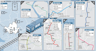
The Maeil Kyeongje's 7 projects (NB our focus below doesn't follow these numbers)

 . Line 1 extension Northwards from Soyosan Station (3 new stations - Choseong-ri, Jeongok, and Yeoncheon): 

Since this extension mostly doubles an existing train, the article logically mentions a low impact on real estate. but it does make commuting more seamless for densely inhabited parts of Yeoncheon-gun, and allows Seoulites to venture further up the Dongducheon valley (not necessarily closer to the DMZ, though: it follows the same axis in this area).

 . Line 4 extension Eastwards from Danggogae Station (3 new stations - Byeollae Byeolgaram, Onam, and Jinjeop):

To be inaugurated next March, this 14.9 km extension is a game changer for this section of Namyangju dotted with major new towns (Byeollae and Jinjeop-eup). But as usual, what a shame that such major clusters were not connected to the grid from day one. 

Of course, this means more commuter traffic for a line already supporting older generation bed towns, but it will also help one of them, Nowon, grow as a cultural hub in Northeast Seoul. Furthermore, the article reminds us of two other projects that will help cope with the flow:

  • Seoul considers doubling Line 4 with an express service for the 31.7 km section within city limits, between Danggogae and Namtaeryeong, with potentially 12 more stations concerned (all the ones connected to other lines). That would leave 12 stations with only the standard service, along with the ones in Gyeonggi-do.
  • The extension of Line 8 Northwards from Amsa Station to Byeollae Station (Gyeongchun Line) by the end of 2023 could later be prolonged to Byeollae Byeolgaram Station via a new station, Byeollae Jungang, further anchoring Byeollae to the South, and making it a transport hub east of Seoul around a decent 'Byeollae Line' backbone.

 . Inauguration of Namwirye Station (Line 8):

Located between Bokjeong and Sanseong Stations in Seongnam, Namwirye doesn't really support Wirye New Town which, as the author mentions, would have much more impact. But he's not taking into account a tramway bound to deliver the goods: the construction of the Wirye Line is just starting these days.

'#Seoul about to start the construction of its first #tramway in decades (#WiryeLine - 12 stations, 5.4 km - to open i 2025). Line announced 8 years ago (http://seoulvillage.blogspot.com/2013/08/seoul-lrt-projects-update-part-22.html) #transports' (20211220 - @theseoulvillage)


 . Gyeongui Jungang Line extension Northeastwards from Imjingang Station to Dorasan Station

In this part of Paju, as the article confirms, 'nothing to do with real estate'. This line is simply inching further towards Kaesong, now a reasonable walk away... provided of course you've got all the papers to enter the DMZ at that most strategic point. For the moment, you're mostly connecting Seoul to a giant, empty parking lot: doesn't look like many workers will commute any time soon to the Kaesong Industrial Complex... Let's hope that some day, this dead end will be prolonged into a friendlier North Korea.


 . Seohae Line extension Northwards from Sosa Station to Wonjong Station (via Bucheon Stadium Station)

As we've already seen (in "Twice upon a time in the West"), there's a lot going on around Bucheon. This vertical will split much earlier the traffic to/from Seoul between the North (Line 1) and the South (Line 7). And it will later be prolonged not only to Gimpo Airport, but also across the river, to Line 3 (Daegok Station, after a stop in Neunggok Station).

If Daegok seems a bit isolated between Goyang's 'old and new' New Towns (Ilsan to the West, Hwajeong to the East), Line 3 leads to more glamorous sites: downtown Seoul and Gangnam. And I wouldn't be surprised to see this new, vertical airport line that will go from Goyang to Hwaseong (for now, Ansan remains the Southern limit) venture further to the North-Northeast and connect to more New Towns.


 . Sillim Line inauguration (from Gwanaksan Station to Saetgang Station)

Thanks to this precious new vertical connected to Line 9 (Saetbang), Line 1 (Daebang), Line 7 (Boramae), Line 2 (Sillim), 'I live in Bongcheon-dong' will sound a lot more uplifting. But in parallel to this LRT,  Western Seoul needs more verticals (Gangnam-gu already getting it's fourth!), starting with Seobu Line...


 . Shinbundang Line Northwards extension from Gangnam Station to Sinsa Station:  

The article made its headline on the star extension because it's about real estate and money, and we're talking expensive real estate (Gangnam-daero), and expensive stations: Gangnam on Line 2, Sinnonhyeon on Line 9, Nonhyeon on Line 7, and Sinsa-dong on Line 3. No new stations, but hopefully fewer cars on the Hannam Bridge once Sinbundang's next profitable extension to the North will lead across the river and Yongsan, all the way to Yongsan Station.

*

Beyond railway and subway projects, Maeil Kyeongje also mentioned work on more sections of the capital region's Second Ring Expressway, which will definitely have some impact. But what the region needs is more public transportation, and a better dialog within Gyeonggi-do, beyond the usual Seoul-suburbs dialog.

It's always good to connect existing dots, and the Ansan-Bucheon-Goyang axis is very welcome, but no new major urban projects should be allowed without a direct connection to the network.

The problem is that Gyeonggi-do is poorly managed, and this has something to do with the way big cities compete with each other without a real regional authority. Only the State has the potential to force some collaboration, or at least more coopetition and less competition within Gyeonggi-do. The lack of political will and strategic vision results in the multiplication of projects cannibalizing each other, a suicidal rat race as the population ages and declines. Clearly, there are countless ways of spending less, better, and still generating much more value for everyone.

 
Seoul Village 2021
Welcome to our Korean Errlines! Follow Seoul Village on Facebook and Twitter, follow me on Instagram.
Download 'Seoul VillageS', the free ebook.
Bookmark and Share

* ""딱 역 3개인데, 폭발력 엄청나다"…판교 분당 부동산 난리난 이유" (Maeil Business Newspaper 20211226)
** see "Seoul subway to gain 89 km by 2025" (June 2015), "Seoul LRT Projects Update (Part 1/2)" and "Seoul LRT Projects Update (Part 2/2)" (August 2013, following "If you ain't broke, fix it: Seoul, Welfare and Railways Deficits" - July 2013). See also all subway related posts.

Monday, May 6, 2019

Twice upon a time in the West

The Minister of Land, Transport and Tourism came up with a new batch of developments for the capital region*, including new public transport projects, and unfortunately more instances of Korea's failed 'New Town' model, at the very moment the country experiences a slump in housing prices, and an oversupply of dwellings. The aim is actually to make sure the prices remain low for a while, which doesn't seem a bad idea, except that in Korea's speculative zero sum game, this necessarily means more losers, and more dead neighborhoods in the short, medium, and long term.

2 'New Towns', 26 small-to-medium-sized developments, 1 BRT, 1 subway line:

Following the first three announced last year (Incheon Gyeyang, Namyangju Wangsuk, Hanam Gyosan - in blue on the map below, which also shows future GTX lines), two more 'Greenfield New Towns'** will be created one kilometer West of Seoul, one on each side of the Han River (in red):
  • Goyang Changneung: 38,000 households in Deokyang-gu, Goyang (Yongdu-dong, Hwajeon-dong)
  • Bucheon Daejang: 20,000 households in Ojeong-gu, Bucheon (Daejang-dong, Wonjong-dong)

In a more acupunctural approach, 26 small and medium-sized residential projects shall add 51,517 households in already developed neighborhoods:


Transports-wise, the government's package proposes two new public transport lines, and road extensions:
  • a 17.3 km-long "S-BRT" line (NB does 'Super - Bus Rapid Transit' mean super dedicated infrastructures for buses?) between Gimpo Airport Station and Bucheon Sports Complex Station, around Gimpo Airport, with connections to subway lines 5, 9, and even 7 (Bucheon Stadium Station). It will also reach Cheongna BRT.
  • a new subway line will connect Goyang City Hall to Saejeol Station (Line 6), and intersect with Line 3, GTX-A, and Gyeongui Line at Daegok Station.
  • A new motorway will connect Baekseok-dong (Ilsan) to the Seoul - Munsan expressway (Gogang, Seoun interchanges).
  • Susaek-ro (already hosting 3 of the new housing projects judging by the map), and Worldcup-ro shall gain layers to cope with a growing traffic towards downtown Seoul as well as towards Yeouido and Gangnam.
Bucheon's new S-BRT line around Gimpo Airport
Goyang's new subway line


The good, the bad, and the ugly:


Overall, if you consider the three announcements made since last December, the State plans to sell 73,000 homes by 2022, 67,000 in 2023, 58,000 in 2024, 61,000 in 2025, and 44,000 in 2026, which may provide more options for affordable housing, but also amplify Korea's oversupply of dwellings. The only clear winner seems to be IKEA Goyang, today an outpost, but tomorrow ideally located to serve the new town.

At least, for a change,...:
  • ... Seoul intra-muros is spared from more of the large-scale New Towns that destroyed so many of its neighborhoods (including the seven buried under Gyonam New Town). 
  • ... a 'Greenfield New Town'** adds some urban continuity instead of pushing urban sprawl further afield: on paper, Goyang Changneung shall better tie Ilsan to the capital.
  • ... transports, including public ones, are better phased and synced with new major developments (new subway, BRT, GTX lines around Goyang and Bucheon new towns, respectively top and bottom):


This remains an absurd case where we add commuting traffic before solving existing problems upstream and downstream. Yes, commuters from the latest new town will reach Seoul faster, but they will slow down commuters from Ilsan's 'older new town', and more cars will flock into Seoul's Western bottlenecks, even if some cosmetic touches are added along Susaek-ro. Urban planners went as far in the irony as to name their concrete monstruosity after the Joseon Royal Tomb*** it will deface.

In this young millenium, any new project should aim at the very least at zero emission and zero increase in car traffic, and this is obviously not the case. I nonetheless appreciate the new public transport lines: the BRT will add some verticality and fluidity across Bucheon, and Goyang will better split its commuters between line 3 and 6.

All this also means that the construction of Seobu Line / Seobuseon becomes even more urgent (see "Seobu Line confirmed as Seoul's LRT top priority"). Just months ago, the project was delayed because SNU wanted to prolong the line further into its campus, and now a boost comes from the other end of the line, the national government speeding up the agenda, and footing the bill for the first 7 stations. Because actually, this new Goyang line constitutes the new beginning of the most defining project for the Western half of Seoul's subway network. Now hopefully, the whole line should be completed by 2026.

On the other side of the Han River, Bucheon will clearly benefit from a denser public transportation network. How the new town will coopete with Magok District or Gyeyang Techno Valley remains to be seen....


Seoul Village 2019
Welcome to our Korean Errlines! Follow Seoul Village on Facebook and Twitter, follow me on Instagram.
Bookmark and Share
Add this page to your favorites

* see for instance in Today's Chosun Ilbo: "3기신도시 고양 창릉·부천 대장동 등에 11만가구 공급", "새절역~고양시청 철도, 김포공항역~부천종합운동장역 BRT 신설", or in Today's Joongang Ilbo: "집값 다시 뛸라...집값 약세 둔화에 3기 신도시 '기습 발표'" (UPDATE 20190508 "To cool real estate, gov’t plans two new towns")
** as defined in "Wet eyes for wetlands and urban mirages"
*** see "Royal Joseon Tombs Become UNESCO World Heritage Properties
**** and by the way, these latest developments make even more irrelevant the Gangbuk Line project drafted a couple of months ago - see "Gangbuk LRT - Naebu v. Seobu, or PARK v. OH?")

Wednesday, December 18, 2013

Seoul-Namyangju? Check. East Gyeonggi? Still To Be Defined

Now with the full support of Seoul, Namyangju, and the Ministry of Transport, the extension of Subway Line 4 from Danggogae Station (Sanggye-dong, Nowon-gu, Seoul) to Jinjeop Station (Jinjeop-myeon, Namyangju) shall be, as expected, delivered by 2019.

Pre-feasibility studies confirmed a project we already detailed earlier, most recently last year*:
"In a diagonal parallel to the Gyeongcheon Line (railway for Chuncheon), the 14.5 km extension from Danggogae will create three stations in the city of Namyangju: Byeollae (Byeollae-dong), Onam (Onam-eup), and Jinjeop (Jinjeop-eup). All three correspond to new towns, not to mention (see reminder) today's terminal itself, Danggogae Station, at the center of the future Sanggye New Town. I bet many inhabitants may feel more like in an extension of Nowon-gu than in a new Namyangju neighborhood: there's no direct railway connection to Namyangju city hall in Geumgok-dong, and Nowon Station with its city hall and attractions is just 1 to 4 stations away.

Sanggye, Danggogae, and Byeollae all lie along Deongneung-ro, an axis already very congested by traffic jams. The only road cutting through Buramsam (in its middle) became an important entry point into northeastern Seoul when the Seoul Ring Expressway was completed: located halfway between Uijeongbu I.C. and Guri I.C., Byeollae I.C. instantly relieved the saturated Toegyewon I.C. gateway. But the road was not dimensioned for that traffic, and turned into a bottleneck."
I positioned Danggogae, Byeollae, Onam, and Jinjeop on Seoul Village map, and as you can see, a stop in  Jinjeop-eup could be added (maybe near Naegok-ri,, between Byeollae and Onam):


View Seoul Village in a larger map

If you zoom out from there, you see how this Eastern New Town Line takes the Wangsukcheon valley towards Pocheon, not the greatest 'pull' to prolong it even further.

But again, the way new towns have been decided across the capital region never followed any grand, long term vision combining from the start urban development with transit solutions. For instance, it would have been so easy to plan an arch from Uijeongbu to Hanam via Namyangju and Guri, in order to build a strong vertical backbone for eastern Gyeonggi-do, and instead of weak horizontal fishbones sticking out from the capital, a sounder dialog with Seoul.
 
Note that this Eastern New Town Line, that has been on the map for ages, was not even mentioned in Seoul Metropolitan Rapid Transit Master Plan. Now you know why I preferred the previous 'big picture' I added in my focus, where such hubs as Nowon-Sanggye appear more clearly (see "If you ain't broke, fix it: Seoul, Welfare and railways deficits").

Seoul Village 2013
Welcome to our Korean Errlines! Follow Seoul Village on Facebook and Twitter
Bookmark and Share
Add this page to your favorites

* see "Spectacular extensions of Seoul Subway Lines 4-5-6-7 ?" (April 2010), followed by "Seoul subway updates : gos, no-gos, maybes" (January 2011) and "Nowon confirmed as Seoul's northeast hub" (October 2012)

Tuesday, October 2, 2012

Nowon confirmed as Seoul's northeast hub

PARK Won-soon recycled yet another project of the OH Se-hoon administration: turning Nowon into Seoul's northeastern hub. The old concept received a boost last month, when the government accepted to lower the share of expenses to be paid by local authorities from 40 to 25%.

Which means two things:
- the extension of Subway Line 4 from Danggogae to Namyangju, first announced in 2007, will be delivered. I had little doubt about that: it was the soundest and most profitable project among the four laid out two years ago (see "Spectacular extensions of Seoul Subway Lines 4-5-6-7 ?" - April 2010, followed by "Seoul subway updates : gos, no-gos, maybes" - January 2011)
- the heart of Nowon, around Nowon Station itself, will be beefed up as scheduled, but instead of the major air terminal initially planned (see my "Nowon-gu" focus of June 2007), a gigantic complex shall rise, with 40+ storey apartment towers, hotels, and a commercial and convention center aiming at rivaling the COEX Mall

After that, Nowon-gu will finally discard its image of bed town, and extend its already strong influence over Gyeonggi-do neighbors: after Jangam new town (Uijeongbu, Line 7), Namyangju new towns (Line 4) are more likely to feel anchored to this hub within Seoul city limits than to their own local administration. 

For Nowon's future commercial hub, the location has long be selected: Dobong Driver's License test grounds and Seoul Metro train depot occupy three quarters of a huge block next to Nowon Station, and both have been expected to move for years. Four important roads surrounding this massive area:
- East: Dongil-ro, northeast Seoul's backbone, between Nowon and Madeul Stations (Line 7).
- South: Sanggye-ro, between Jungnangcheon and Nowon Station (with subway Line 4 overground)
- West: Dongbu Expressway, along Jungnangcheon

- North: Nowon-ro, in front of Jungang Apt Block 10 and Nowon High School, leading to Sanggye Bridge and Dobong-gu.

The extension of Line 4 also confirms Nowon Station as Northeast Seoul's brightest spot:
- To the West, Dobong Station (Lines 1 and 4) will be even more distanced. Yes, the Uijeongbu axis is bound to grow stronger, and the future Suyu LRT won't be that far, but if Seoul reaches further northwards, it will be through Line 7. For the people living in Jangam new town, even from the other side of Seoul Ring Expressway (# 100), Nowon Station feels already much closer than downtown Uijeongbu.
- Along Line 7, Nowon's closest rival lies far down south, at the intersection with Line 2: Konkuk University Station has been completely revived by the Starcity - Emart complex. Gunja (intersection with Line 5) has some potential, and Taereung may go up should Line 6 be prolonged, but catching up with Nowon won't be that easy.
- The old but vital Line 4 vertical already connects Seoul with southern Gyeonggi-do, carrying people from 5 cities (Siheung, Ansan, Gunpo, Anyang, and Gwacheon) straight into 9 of the capital's 25 districts (Seocho, Dongjak, Yongsan, Jung, Jongno, Seongbuk, Gangbuk, Dobong, Nowon). But if Nowon was the last frontier new town back in the late 1980s, it is now becoming the entry point to Seoul for a new generation of new towns, this time from northeast Gyeonggi-do.

In a diagonal parallel to the Gyeongcheon Line (railway for Chuncheon), the 14.5 km extension from Danggogae will create three stations in the city of Namyangju: Byeollae (Byeollae-dong), Onam (Onam-eup), and Jinjeop (Jinjeop-eup). All three correspond to new towns, not to mention (see reminder) today's terminal itself, Danggogae Station, at the center of the future Sanggye New Town. I bet many inhabitants may feel more like in an extension of Nowon-gu than in a new Namyangju neighborhood: there's no direct railway connection to Namyangju city hall in Geumgok-dong, and Nowon Station with its city hall and attractions is just 1 to 4 stations away.

Sanggye, Danggogae, and Byeollae all lie along Deongneung-ro, an axis already very congested by traffic jams. The only road cutting through Buramsam (in its middle) became an important entry point into northeastern Seoul when the Seoul Ring Expressway was completed: located halfway between Uijeongbu I.C. and Guri I.C., Byeollae I.C. instantly relieved the saturated Toegyewon I.C. gateway. But the road was not dimensioned for that traffic, and turned into a bottleneck.

Construction for the subway shall start in 2015 and end in 2019, but expect more hiccups on the way, starting with the feasibility studies planned during 2013, after the elections.

To be continued.

Seoul Village 2012
Welcome to our Korean Errlines! Follow Seoul Village on Facebook and Twitter

Monday, January 3, 2011

Seoul subway updates : gos, no-gos, maybes

Political and budgetary tensions tend to slow down infrastructure projects, and only a few months after promising announcements (see "Spectacular extensions of Seoul Subway Lines 4-5-6-7 ?"), some subway line extensions are already being reconsidered. Here's the score as of today :

- Line 7 : the Northern terminus, Jangam Station, is quite close to booming Uijeongbu, and it made perfect sense to complete the connection with the closest hub, Nowon Station (unlike the inital project, which went all the way up to Pocheon)... but this case is now officially closed : rentability for this extension was evaluated at only 43% of the break even point, probably because Uijeongbu is already on Subway Line 1. So Jangam, a former shantytown now almost completely redevelopped, remains the last post before expressway 100.

- Line 5 : the
extension to Hanam just passes the threshold (rentability : 1.04). Now it's just a matter of time and priorities.

- Line 4 :
obviously the most vital project of all, the Danggogae-Namyangju extension will as expected fly, but a bit beyond schedule : if it scored 1.27 for rentability, financing remains an issue, and local officials wasted one year instead of pushing it.

Note that Seoul Metro (Lines 1, 2, 3, 4) started a trial with LED lights in several stations along Line 3 : they burn 28 W instead of 32 for fluorescent systems. It sure will take more than new bulbs to finance new subway stations, but that's a good resolution for 2011.

Seoul Village 2011

Monday, April 12, 2010

Spectacular extensions of Seoul Subway Lines 4-5-6-7 ?

Seoul, Incheon, and Gyeonggi-do signed series of agreements to pursue the dream of a common "Gyeongin Megacity" : together, they already claim 25 million citizens and a considerable portion of Korean economy, but they are eager for more. More visitors, more businesses, and more infrastructures.

Rapid transit solutions, such as underground driveways and the GTX / Great Train eXpress, are under way to make most parts of the megacity accessible within one hour. Korea's first train line already linked Incheon (then Jemulpo) with Seoul* : Gyeongin Line (경인선) was built in 1899.

The extension of Seoul subway beyond city limits is another major project. Of course, all regional networks are already connected, but lines 4 to 7 would grow considerably :

. Line 4 : 17 km extension from Dangogae to Jinjeop-eup, a major New Town in Namyangju - note that Dangogae itself is to become the center of Sanggye New Town. As planned, the subway car depot shall move from Sanggye-dong, along with the Dobong Driving Center, giving way for the long expected establishment of Nowon Station area as Seoul's Northeastern hub (see 2006 focus on Nowon-gu). To me, this project will fly because all parties, and particularly Nowon-gu and Namyangju, are dying to see it happen.

. Line 5 : 11 km extension from Sangil-dong to Hasangok-dong in Hanam. That's beyond Circular Highway 100 at the Hanam InterChange with Highway 35, which also leads to Paldang Bridge (consistent with the recent extension of Hangang bike road). I guess this line would follow road 43, a densily populated axis. To me, all this depends on the merger project** between Hanam, Seongnam, and Gwangju. Hanam cruelly lacks a subway line, but decisions could take time.

. Line 6 : 6 km extension from Sinnae to Donong-dong in Namyangju, another New Town (Buyeong e-Dreamtown). And that's also beyond Highway 100, at Guri InterChange. This one could also fly, but there's already the Jungang Line (train), and the express train to Chuncheon will soon be inaugurated. I would rather recommend a vertical line across Guri and Namyangju, for instance from Sinnae to Uijeongbu, parallel to Circular 100.

. Line 7 : 33 km extension from Jangam to Pocheon, up North. Line 7 was already a quite long one (it almost reaches Bucheon), but this would open new horizons for Northeastern Gyeonggi-do and beyond. Clearly, the region wants to put this area on the map, to correct geographic imbalances in economic development... but who would support the investment ?

Stay tuned until the next announcements.

Anyway, I'm not keeping track of all new subway projects : that would be a full time job.

Seoul Village 2010

* actually at the beginning Noryangjin (thus the fish market), which back then didn't belong to Seoul but Siheung
** see "Gwangju completes Seongnam-Hanam merger"

Wednesday, March 31, 2010

Tighten your greenbelt

The Ministry of Land, Transport, and Maritime Affairs delisted five more greenbelt areas in Southern Seoul totalling 21.16 million square meters to make room for urban development, including 87,000 "Bogeumjari" ("Sweet Home") apartments for low income families to be delivered in 2014.

"Sweet Home" means low cost for the owners (long term projects between 15% and 50% below market price), but dear price for the environment.

Last year, two bogeumjari series had already claimed 17 million square meters of protected land in Seoul and neighboring Gyeonggi-do cities :

* 8.06 M sqm for 39,000 apartments (announced in May 2009)
. in Seoul : Segok-dong in Gangnam-gu, Umyeon-dong in Seocho-gu. The opportunity to boost mixity in two wealthy "gus", but both areas are separated from the center by mountains.
. in Goyang : Wonheung-dong in Deogyang-gu. A promising area which will open a new subway station on Line 3 between Samsong and Wondang. Both stations were indeed insanely far away from each other.
. in Hanam : Misa-dong. That's along the Han river, there's a boat race infrastructure in the middle of the dong.

* 8.89 M sqm for 40,505 apartments (announced in October 2009)
. in Seoul : Segok again, and Naegok-dong, next to Segok but in Seocho-gu
. in Bucheon : Okgil-dong, at the frontier with Guro-gu
. in Guri (West) : Galmae-dong, an important entry point to Taereung
. in Namyangju (West) : Jingeon-eup, further afield following the train line.

The new series announced yesterday cover 5 areas, with a focus on the Seoul-Incheon axis and a major New Town in Gwangmyeon :
. in Seoul : 676,000 sqm (4,500 apts including 4,300 bogeumjari) in Hang-dong, Guro-gu. That's between Okgil-dong (see above) and Onsu Station, the very important junction between subway Line 7 and the Seoul-Incheon train.
. in Gwangmyeon and Siheung : 17.367 M square meters (95,000 apts including 69,000 bogeumjari). close to the previous cluster, a gigantic new town is planned, ideally positioned to serve both the Capital city (Gwangmyeon borders Guro-gu and Geumcheon-gu, industrial areas) and it's main international entry point (Incheon, its airport, its harbor). The small number of apartments covers only the public project, not private developments.
. in Incheon : 840,000 sqm (6,000 apts / 4,300 bogeumjari) in Guwol-dong, Namdong-gu. Surrounded by highways 100, 120, and 50, this area is not well served by public transportations, but this might change : I think the Government considers a bed town equidistant from old (harbor) and new (Songdo) centers.
. in Hanam : 1.708 M sqm (12,000 apts / 8,400 bogeumjari) in Gamil-dong. Let's hope Seoul Subway Line 9 will continue this way... even if Songpa-gu / Gangdong-gu residents keep lobbying for a different scenario : a SW/NW parallel to lines 5 and 8.
. in Seongnam : 569,000 sqm (3,800 apts / 2,700 bogeumjari) in Godeung-dong, Sujeong-gu, North of Pangyo InterChange.

More supply, then, with the usual promise to bring down the prices. Unlikely if the discount is only 15%, and if the new houses are only meant as a receptacle for victims of redevelopments in more demanded areas, featuring the standard "apateu" model that disfigured Korea over the past 40 years.

One thing is sure : the Government keeps tightening Seoul's greenbelt, and something will have to be done to make for the loss.

Seoul Village 2010

Friday, March 26, 2010

Riverside bicycle road extended to Hanam

On March 31, the bike road following the Southern riverside of Hangang will by prolonged Eastwards by a new 13.5 km section, completing a 49.3 km-long Goyang*-Seoul-Hanam stretch.

The new section starts from Gwangnaru recreational park (광나루 유원지) in Gwangjin-gu, passes by Amsa-dong, Gangdong-gu (famous for its prehistoric site), and reaches the Paldang Bridge (팔당대교) in Hanam.

At that bridge, you are at the feet of two mountains : Duribong (566 m) in Hanam, and Yebongsan (679 m) in Namyangju on the other side of the river. So far, these hulky patches of green have kept urban development at bay, and I hope the Gwangju-Seongnam-Hanam merger** will not ruin this area.

From this new terminus, the bike lane may continue upstream towards the Paldan Dam and beyond Yangpyeong area, a very touristic spot. It could also connect to Namyangju city, right across the bridge.

But for the moment, Gyeonggi-do has already a lot of fish to fry. The province has invested KRW 70 bn in bicycle infrastructures since 2007, and 5 other projects are about to be completed, totalling 27.1 km :
. 5.6 km in Ansan : Sihwa Industrial Complex - Seonggok-dong
. 9 km in Gimpo : Han-gang New Town - Unyang Samgeori
. 2 km in Pyeongtaek : Songbuk-dong (Ojwa Samgeori) - Seojeong-dong (Bokchang Overpass)
. 6.5 km in Dongducheon : Bosan Station - Habongam-dong
. 4.0 km in Yeoncheon-gun : Dosin-ri (Sinseo-myeon) - Yeoncheon Bridge

Of course, Gyeonggi-do (over 10,000 square kilometers) will never have a network as dense as Seoul (605 sqkm, already 10 times more bicycle infrastructures), but that's a beginning.

Of course, this is by no means a network : Ansan is far (Southwest of Seoul) and Pyeongtaek even further. But the Gimpo New Town segment may eventually join the Goyang end of the Seoul lane... and with some imagination, the last two segments almost seem to be heading towards the Peace Bicycle Nuri Road** : the Jungnangcheon bike lane in Northeast Seoul already goes along Nowon-gu and towards Uijeongbu between Bukhansan and Seoraksan, why not continue in the same direction, straight to the North ? After Uijeongbu come Yangju, Dongducheon, Yeoncheon, Chorwon... and the DMZ.

Seoul Village 2010

* at Haengju Bridge (Deokyang-gu, Goyang-si, Gyeonggi-do)
** see "
Gwangju completes the Seongnam-Hanam merger"
*** "
Take a ride on the wild side"

Map : gg.go.kr (Gyeonggi-do's website)

Sunday, June 28, 2009

Royal Joseon Tombs Become UNESCO World Heritage Properties

For its 33rd session (to be finalized tomorrow, June 30), UNESCO added 13 sites to its prestigious World Heritage List*, but put 3 on the Danger list and even removed one, the Dresden Elbe Valley, because a bridge had been built in the middle of the heritage zone in spite of strong warnings issued in 2006.

A clear message to all countries boasting such prestigious properties : big responsibilities come with the honor, so take good care of them or else...

Typically, preserving Korea's newly listed property (its ninth**) will require some organization : it stretches over 1756.9 ha (4251.7 ha including buffer zones), and 18 locations scattered across Seoul, Gyeonggi-do (most notably the Donggureung complex in Guri), and Gangwon-do (1 site).

After Goguryeo Tombs, Gyeongju Tumuli, Jongmyo, and even certain Dolmens, the UNESCO is once more celebrating Korean funeral traditions and rites : an ensemble of over 50 tombs of either Kings and Queens (generally ending in "neung" / 릉), or other members of royal family ("won" / 원), including a royal concubine and a 9 month boy. Some tomb names end in "myo" / 묘, the more generic term for cemeteries and graves.

The obligation to preserve buffer areas beyond the sites is excellent news for the environment and the quality of life around the dead : as the UNESCO pointed out, Joseon Tombs are "typically protected by a hill facing south toward water and layers of mountain ridges in the distance"**. One more argument in favor of
the protection of Seoul mountains !

Excellent news also for certain Districts which struggled to build an identity or to draw tourists (ie Unpyeong-gu, Dobong-gu, Nowon-gu, Seongbuk-gu). Tombs are generally well specified in maps and signs, but most of the people leaving nearby didn't care much about those cultural assets (when there's a really nice park or an elaborate complex, that's a different story). For sure, associations which pushed for the UNESCO recognition will feel less lonely now.

Main Royal Joseon Tombs :


In Gangwon-do (1 site, 1 tomb) :

. 1 in Yeongweol (Yeongwol-gun, Yeongwol-eup, Yeongheung-ri) : one more reason to visit Jangneung King Danjong's Tomb (see "King Danjong and Korea's curse") !

In Seoul (6 sites, 11 tombs) :

. Dobong-gu (1 site, 1 tomb) : Yonsangunmyo in Banghak-dong
. Dongdaemun-gu (0 site, 2 tombs) : Sunginwon and Yeonghwiwon are located on Hongneung-gil in Cheongnyangni-2-dong, but associated with Uireung site in Seongbuk-gu. In the former lies the young Yi Jin (1921-1922), son of King Yeongchin, Korea's last Crown Prince. In the latter, King Gojong's first royal concubine Sunheon - 1854-1911).
. Gangnam-gu (1 site, 2 tombs) : Seonjeongneung in Samseong-dong regroups Jeongneung (King Jeongjong - 1488-1544), and Seollung (Queen Gonghye - 1456-1474).
. Nowon-gu (1 site, 2 tombs) : Taegangneung (Taereung and Gangneung) in Gongneung-dong.
. Seocho-gu (1 site, 2 tombs) : Heoninneung (Heonneung and Inneung) in Naegok-dong.
. Seongbuk-gu (2 sites, 2 tombs) : Uireung includes Uireung itself, the tomb of King Gyeongjong (1688-1724) in Seokgwan-dong, and two tombs located in Dongdaemun-gu. Uireung used to be managed (and not so poorly preserved) by the KCIA. I wonder how the other site, Jeongneung (in Jeongneung-dong), ever managed to get the nod from the UNESCO : it now lies at the feet of Naebu expressway before the Bugak Tunnel leading to Pyeongchang-dong, and this poor place often comes up when I think of peaceful areas ruined by development. Unless... could it be a plot to remove the Naebu overpass ?

In Gyeonggi-do (15 sites, 45 tombs) :

. Gaeseong (2 sites, 2 tombs) : Huneung and Joeneung, respectively in Ryeongjeong-ri and in Sangdo-ri, two villages located in Panmun-gun (Panmun county).
. Gimpo (1 site, 1 tomb) : Jangneung in Gimpo-eup, Pungmu-ri (site different from Paju's Jangneung)
. Goyang (2 sites, 16 tombs, including one in the city of Gwangmyeong) : Seosamreung or the "3 Western graves" (Hwireung, Hyoneung, and Yoeneung, plus Sogyeongwon, Uiryeongwon, Hyochangon and Hwimyo) are all located in Wondang-dong, Deokyang-gu. Seooreung or the "5 Western graves" (Changneung, Gyeongneung, Heungneung, Ikneung, and Myeongneung) are in Yongdu-dong, but the "site" also includes tombs in Wondang-dong (Daebinmyo, Sugyeongwon, and Sunchangwon), and Yeonghoewon in Noonsa-dong, Gwangmyeong... a city on the other side of Seoul.
. Guri (1 site, 9 tombs) : the Donggureung complex in Toegyewon-myeon, Inchang-dong clearly stands out for its shape and significance. It hosts Geonwolleung, the tomb of King Taejo (1335-1408), founder of the Joseon Dynasty, and 8 others (Hyeonneung, Mokneung, Huineung, Sungneung, Hyeneung, Wonneung, Suneung, Gyeongneung).
. Hwaseong (1 site, 2 tombs) : Yoonggeonneung (Yoongneung and Geonneung) in Annyeong-dong.
. Namyangju (4 sites, 8 tombs) : Saneung (in Jingeon-eup, Saneung-ri) owes its name to the "four graves" ("sa neun") it boasts : Saneung itself (tomb of Queen Jeongsun, 1440-1521), Gwanghaegunmyo, Anbinmyo, and Seongmyo. Hongyuneung (Hongneung and Yuneung) is in Gumgeok-dong and Hongseondaewongunmyo in Hwado-eup, Changhyeon-ri. Gwangneung hosts the "bad" King Sejo in Jinjeon-eup, Bupyeong-ri.
. Paju (2 sites, 4 tombs) : Jangneung (different from Gimpo's - this one is in Tanhyeon-myeon, Galhyeon-ri) and Samreung (in Jori-eup, Bongilcheon-ri). As the name suggests, Samreung boasts three tombs : Gongneung, Seunneung, and Yeongneung.
. Yangju (1 site, 1 tomb) : Onneung in Yeoju-gun, Jangheung-myeon, Ilyeong-ri.
. Yeoju (1 site, 2 tombs) : Yeongneung in Neunseo-myeon, Hwangdae-ri consists of Joseon Sejongdaewangneung Yeongneung, tomb of the Great King Sejong (1397-1450) and his wife Queen Soheon, and Joseon Hyojong Yeongneung, tomb of the bellicose King Hyojong (1619-1659).

The Cultural Heritage Administration of Korea are working on the best way to cope with this wonderful honor and harmonize the visits. They just opened a specific website (not in English yet but it's a matter of days I guess) : royaltombs.cha.go.kr.

And of course, don't restrict your visits to UNESCO stars and Joseon royalty. There are tombs all over Seoul, for example in the National Cemetery, or Hyochang Park, and even almost anonymous ones in bits of land clinging to mountains. I even saw one in Sanggye right at the feet of an appartment building. To me, the epitomy of the Seoul tombstone appateu.

SM 2009

* see "13 new sites have been added to UNESCO’s World Heritage List which lost one site while three were placed on the Danger List" (UNESCO 20090628)

** Korea now owns 9 of the list's 890 properties (8 cultural properties and 1 natural property) :
. 3 since 1995 : Haeinsa Temple Janggyeong Panjeon, depositories for the Tripitaka Koreana Woodblocks (see Seoul Village focus), Jongmyo Shrine, and Seokguram Grotto + Bulguksa Temple
. 2 were added in 1997 :Changdeokgung Palace Complex and Hwaseong Fortress
. 2 in 2000 : Gyeongju Historic Areas and the Dolmen Sites in Gochang, Hwasung and Ganghwa
. 1 in 2007 : Korea's only natural property, Jeju Volcanic Island and Lava Tubes
. 1 in 2009 : Royal Tombs of the Joseon Dynasty

*** UNESCO's description of the property :

The Royal Tombs of the Joseon Dynasty (Republic of Korea) form a collection of 40 tombs scattered over 18 locations. Built over five centuries, from 1408 to 1966, the tombs honoured the memory of ancestors, showed respect for their achievements, asserted royal authority, protected ancestral spirits from evil and provided protection from vandalism. Spots of outstanding natural beauty were chosen for the tombs which typically have their back protected by a hill as they face south toward water and, ideally, layers of mountain ridges in the distance. Alongside the burial area, the royal tombs feature a ceremonial area and an entrance. In addition to the burial mounds, associated buildings that are an integral part of the tombs include a T-shaped wooden shrine, a shed for stele, a royal kitchen and a guards’ house, a red-spiked gate and the tomb keeper’s house. The grounds are adorned on the outside with a range of stone objects including figures of people and animals. The inscription of the Joseon Tombs completes the two earlier series of Korean Peninsula royal tombs inscribed on UNESCO’s World Heritage List: the Gyeongju Historic Areas, Republic of Korea, and Complex of Koguryo Tombs, Democratic People’s Republic of Korea.

books, movies, music