NEW - download 'Seoul VillageS (서울 마을들)', my collection of 12 short fictions now adapted into short films! Get your free copy of the ebook (4 editions: English, French, Korean, Bilingual English-Korean)!

Showing posts with label Eunpyeong-gu. Show all posts

Sunday, December 25, 2022

Seoul Innovation Park on steroids

We've already seen Eunpyeong-gu's former KCDC site mutate into a makers' hub*, a vibrant Nokbeon-dong neighborhood park, and a cultural crossroads** in an underprivileged part of Seoul. Now the city wants to turn this low rise oasis into its gazillionth high rise utopia.

Meet the new and improved Seoul Innovation Park:
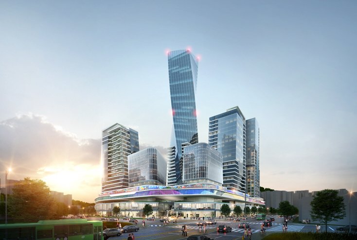


Quite a change from nowadays:

"Vegan Festival in Seoul Innovation Park, Eunpyeong-gu." (@theSeoulVillage 20170511- twitter.com/theseoulvillage/status/866195549707358208)

Okay, all cars shall be parked underground instead of these traditional outdoor sprawls, plus there's also going to be this manicured 'Seoul UIC Campus' (University of Seoul Industry Cooperation), but that's not the same as a laid-back park full of happy families:

As you well know, I'm all for fixing the capital city's unbalances, and Northeast Seoul clearly deserves a boost. Besides, the city already owns this 110,000 sqm site, and it's next to a subway station (Bulgwang Station), close to the Yeonsinnae transport hub (Subway Lines 3 and 6, GTX-A - see "GTX, meet Sinbundang Line"). 

But not exactly there. And we've already seen this not so disruptive concept of futuristic, buzzword-friendly city within the city, with its iconic landmark tower - here, 60 more floors to be filled in a market already suffering from oversupply. Yet another empty alibi for yet another real estate nonsense (many 'apateu' have already risen nearby)? And of all models, why pick the COEX as a symbol of success? 


Needless to say, the grove with its old trees at the entrance, under which kids would play and seek fresh shelter in the Summer, is gone. From the outside, this could be any mall:


This time, it's different, they say. We go 'beyond zoning', we're truly mixing commercial, residential, and business. And this time, promise, we'll build and startups will come. SH Corporation will make sure a diversity of people build a genuine community, a 'Golden Village' where elderlies, newlyweds, single households share the same spaces with all facilities required in changing times.

Sincerely hope that flies but frankly, Seoul, you can do better.


"Seoul's project for Seoul Innovation Park (Nokbeon-dong, Eunpyeong-gu)? A coex-ish hub, very Oh Sehoon-ish urbanism:" (@theSeoulVillage 20221220 - https://twitter.com/theseoulvillage/status/1605025577102032896)


Seoul Village 2022
Welcome to our Korean Errlines! Follow Seoul Village on Facebook and Twitter, follow me on Instagram.
Download 'Seoul VillageS', the free ebook.
Bookmark and Share

* starting with Seoul Creative Lab and Hyebin's FabLab:

"Always nice to visit Seoul Innovation Park's FabLab! Eunpyeong-gu, Seoul." (@theSeoulVillage 20161207 - https://twitter.com/theseoulvillage/status/806453941252673536)

** including, most recently, SEMA Storage in a former KCDC warehouse (see "Nine new museums in Seoul by 2023")

Monday, December 1, 2014

GTX, meet Sinbundang Line

Among the many railway projects presented one year ahead of the Mayoral elections (see "If you ain't broke, fix it: Seoul, Welfare and Railways Deficits"), the Northeast-Southwest diagonal seems to be reaching a consensus between local administrations and the government*. According to its promoters, the cost could be significantly cut - by KRW 5 trillion! - by using existing railway paths, and by sharing infrastructure between the Sinbundang Line and the GTX-A Line in the heart of Seoul.

*

According to the latest proposal (see map below), the common Sinbundang-GTX section shall link Dokbawi Station (Line 6 - Bulgwang-dong, Eunpyeong-gu) to Sinsa Station (Line 3 - Sinsa-dong, Gangnam-gu). Little surprise here:
  • As expected, the first station to pop up in Pyeongchang-dong valley is at the Sinyeong-dong Samgeori. I hope the tentative name "Segeomjeong Elementary School" will be shrunk to "Segeomjeong", the closest landmark.
  • As expected, one stop is added in Seochon on the other side of the Jahamun Tunnel, along Jahamun-ro. That's at Kyungbock High School in Cheongun-dong.
  • As expected, the lines stop at the existing stations of Gyeonbokgung, Gwanghwamun, and Seoul Station.
  • But instead of following the Jungang Line via Seobinggo Station (or Dongbinggo) - Ichon Station - Yongsan Station, the section between Seoul Station and Sinsa Station passes by Noksapyeong. I like that, because that's the opportunity to cover a gap in the map. But Noksapyong will be the only station in a stretch that, as the crow flies, takes at least 6 km. If from the GTX perspective, there should be as few stops as possible, it would be completely stupid to build a new railway along this axis without adding at least one stop. I strongly suggest Huam-dong, where a lot of projects are already under way.  Yes building a new station costs a lot, but this is a simple case of urban planning 101, check the map. A connection with the Jungang Line could be also added (for instance at Hannam Station).
*
At each end of that half-new, 8-station section, GTX and Sinbundang shall go their own ways:
  • From Sinsa Station (South):
    • Shinbundang Line: the extension from Gangnam Station to Sinsa Station, initially planned for 2018 included Nonhyeon and Sinnonhyeon stations (respectively lines 7 and 9). Will it be the case for the subway and not the GTX, or will these connections be scrapped altogether?
    • GTX-A shall reach directly Samseong Station (Line 2): here too, no connection to line 7 and 9. Nice gift for the coex.
  • From Dokbawi Station (North):
    • GTX-A shall reconnect to Line 6 at Yeonsinnae Station, the station next to Dokbawi! Of course, Yeonsinnae is a much bigger hub, also connected to Line 3, but what a contrast with the situation between Seoul Station and Sinsa Station!
    • Shinbundang shall reach Samsong Station (Line 3, Goyang) via two new stations: "Shindo Middle School" and "Jingwan Middle School", at the Western end of Eunpyeong New Town (Gupabal Station at the other end). Shindo lies in the Southern half, at the feet of "Bukhansan Eunpyeong Hanok Maeul", Jingwan in the Northern half. Clearly, the aim is to capture a big chunk of the new town traffic that have saturated Subway Line 3 and Tongil-ro from the beginning (typical example of the poorly planned project - see my previous posts on new towns).
The latest map - Chosun Ilbo 20141202
("신분당선·GTX(수도권 광역급행철도), 鐵路(철로) 같이 쓴다")
*
Whatever the outcome of this project, it's always fun to see how the various constraints play (topography, urban planning logics, cost, politics, speculation, transportation divide...).

Seoul Village 2014
Welcome to our Korean Errlines! Follow Seoul Village on Facebook and Twitter
Bookmark and Share
Add this page to your favorites

*see for instance "서울시 “국토부에 ‘신분당선 서북부 연장선-GTX’ 노선공유 제안”" (DongA Ilbo - 20141126)

Tuesday, August 5, 2014

Bukhansan Eunpyeong Hanok Maeul

Remember Eunpyeong New Town's Hanok Village? In case you missed that milestone project at the feet of Bukhansan and of the new town's towers, here are the main posts where they've been mentioned so far:
I'm inflicting you another update today because in this morning's mail, we received this leaflet for "Bukhansan Eunpyeong Hanok Maeul":


For this project, SH Corporation (Seoul public housing organization) must convince people who are interested in a different proposition, and won't fall with the classic hard selling techniques. Yet they're targeting first-time hanok buyers, not hanok ayatollahs (sorry to that loyal segment of Seoul Village readers; I don't mean to be mean, but you know what I mean!).

Note the absence of mention of the New Town in the branding, the green dominant, and the - relatively - high quality format. This leaflet has been printed on a much higher quality paper and in a more intimate size than the usual real estate ads.

Also significant marketing-wise, a specific 'hanok pedagogy' to lift worries commonly formulated by prospects: won't air conditioning be prohibitive? aren't hanok expensive to build? isn't their maintenance a constant headache? You can live in a hanok and enjoy modern comfort and community services.

On the site too, they did their best to differentiate the hanok village from the New Town:

- The expression 'model house' was replaced by a more respectful 'demonstrative hanok'...


- ... and traditional ceremonies were even performed for the show last year:


At least, as the construction continues, this part of the working site isn't a sea of cranes.

Seoul Village 2014
Welcome to our Korean Errlines! Follow Seoul Village on Facebook and Twitter
Bookmark and Share
Add this page to your favorites

Monday, November 18, 2013

No cablecars in Bukhansan, please

The old Eunpyeong New Town cable car project that raised many critics from environmentalists in the late noughties has been revived yesterday by Seoul Mayor Park Won-soon as a cheap quick fix for recurrent traffic jams between the new town and downtown*. Traffic jams that (sorry for repeating always the same things) should have been avoided in the first place, and public transit solutions considered as core elements of the said new town (an obviousness for any urban planner except - it seems - in this part of the world).

I can't deny the fact that cable cars are cheaper than, say, a railway extension such as the one the same Mayor promised last summer in his initial Seoul Metropolitan Rapid Transit Master Plan, a very ambitious wish list where the Sinbundang Line was supposed to be prolonged to Pyongchang-dong, the infinity and beyond (see "If you ain't broke, fix it: Seoul, Welfare and Railways Deficits). Cable cars are even cheaper than the already environment-unfriendly Eunpyeong-Seochon tunnel considered two years ago, a car-centric nonsense that triggered the following rant from this excuse for a blogger (see "2 more tunnels up North"):
"Eunpyeong-gu definitely needs more connections with the rest of the city, but the priority for a forward looking city should be to develop public transportation, and deter people from using their cars in already saturated areas. 
I mean come on : Seoul is digging tunnels #10 and #11, and not one of them has ever been for a subway or a railway! It's as if the mind frame was set on 1960s and 1970s instead of the new millenium: more people? build more roads, sell more cars! and don't bother with medium / long term consequences! 
This totally contradicts Seoul's efforts to develop tourism and international attractiveness: downtown is not supposed to become again an environmental nightmare and a communication failure."
But Seoul is not Santiago do Chile, where funicular railways made perfect sense to connect higher neighborhoods with the rest of the city. Here, cable cars would follow a roller coaster from ground level to ground level in an endless, preventable eyesore that would totally ruin Bukhansan (via Samgaksan, Bugaksan, Inwangsan), one of the capital's most valuable assets - not to mention, of course, Seoul fortress... and downtown Seoul as a whole, because this monster would go all the way from Gupabal Station to City Hall (either in a straight line of 9.6 km, or in a 11 km course that would pass over Tongil-ro via Yeonsinnae and Dongnimun)! All this to shrink to 20 mn a journey that takes 40-50 mn by car or 30-35 mn by subway!

And they have the gall to sell it as a potential tourist asset as great as the London Cable Car, an urban abomination only topped by the ArcelorMittal Orbit as the most embarrassing erection of the 2012 Olympics (in a city with a recent history already rich in urban disasters). 

Of course the view could be interesting from above, but that's what you'd see from under:

The Emirates Air Line, a.k.a. the London Cable Car, a low cost bridge over River Thames. Now picture that as you stroll around Sejongno, Seochon, or Jeong-dong... "touristic", isn't it?

Brits can do whatever they want over this part of the Thames, I won't let downtown Seoul welcome a new elevated wart, not even a decade after the restoration of Cheonggyecheon.

This project insults the city's past, present and future. Seoul can't fix Eunpyeong New Town's failure by making it even worse and more visible. 

So back to the drawing board, and I'm begging you, next time, please try to look for more sustainable ways.

Seoul Village 2013
Welcome to our Korean Errlines! Follow Seoul Village on Facebook and Twitter
Bookmark and Share
Add this page to your favorites

* see "서울시, 은평뉴타운~서울 도심 케이블카 건설 검토 논란" (Chosun Ilbo 20131118)

NO WAY! Park Won-soon considering cablecar connections between Eunpyeong new town and downtown Seoul! Save Bukhansan from this madness!
twitter.com/theseoulvillage/status/402245416474800128

Friday, November 15, 2013

Songdo, DMC: sequence is of the essence (Part III)

I realize that I've completely forgotten the 3rd part of my series on Songdo and the DMC (see "Songdo, DMC: sequence is of the essence (Part I)" and "Songdo, DMC: sequence is of the essence (Part II)"). I thought I published it last June, and recently found out that it was still stuck in the blog's draft folder. I'll lazily post it almost as it is. The good news is that now I can include a recent development... and spare you, as well as my lazy self, an additional post on the topic.

Reminder: Part I covered sections 0 and 1 of the 'master plan' below, and Part II delivered lot # 2. This Part III wraps it up with bloc 3:
0) City, Interrupted. Puzzle, Ongoing. Landmarks and Landscars
1) Purpose and Identity, Citizens and Citizones, Projects and Projections
2) Connectivity, Continuity and Consistence
3) Longing and Belonging - Sequence is of the Essence

But let me first talk about the piece of news that got me digging into my own junkyard.


Stephane


NB: again, Songdo and the DMC cannot be compared (e.g. scale, timelines, stakes, relative importance for local authorities...), and they don't compete directly. This is not a comparison but a parallel update, with random thoughts about the evolution of ambitious urban projects. See useful links at the end of this post.

UPDATE: download the whole focus in PDF format here.
 
*

(Addendum-Update) A solution to the Great DMC-Susaek Rift?


So what's the above-mentioned 'recent development'? Seoul city announced the other week new ambitions for Northeast Seoul: the campaigning mayor wants to develop a northeast Seoul business hub around the Digital Media City by covering part of the railways between the DMC and Susaek, and - hopefully - by convincing Korail to invest there instead of in the failed Yongsan IBD project* (NB: in a low-rise version of the Seoul Lite aerotropolis dystopia?).

If Korail owns the land, that bruised institution will probably think twice - and ask for more guarantees - before embracing this new embryo of a concept. At least it does address one of the DMC's key issues, one that - again - I highlighted in the previous part of this focus:


"To the North, a disgracious urban separator prevents the DMC from dialoguing with Susaek-dong and Eunpyeong-gu: the Gyeongui Line. Seoul city considers burying it, but it will take time and here, it's as wide as around Seoul Station. And it's doubled with yet another major entry point to Western Seoul: a 6-to-8-lane axis that goes straight from Gwanghwamun to the heart of Goyang and Ilsan, first as Sajik-ro, then as Songsan-ro, here as Susaek-ro, and through Gyeonggi-do as Jungang-ro. Overall, if you include the thin layer of buildings sandwiched between the railways and the road, that's a 300 m - wide band, almost as thick as the bar of the "T". The Digital Media City Station (AREX, Gyeongui Line, Subway Line 6) does connect both sides, but the whole area will boom the day a Gwanghwamun Square-like revolution helps pedestrians claim that bandwidth, critical for seamless communications."


Not very inspiring, the first sketches remind me not only of countless similar projects (of course, this one includes a hotel, a convention center, and a Time Square - style mall), but also of Paris La Defense's "Great Slab", or the initial Beaugrenelle mess - not exactly the epitome of sustainable, seamless urban continuity:


The projected DMC-Susaek hub covering the Gyeongui Line near Susaek / DMC Station

In concrete terms (and obviously in concrete, period), Gyeongui Line shall be covered around Susaek - Digital Media City Station, between Gayang-daero and Jeungsan-ro (East-West, along what I called the bar of the DMC's "T"), and between Susaek-ro and Seongam-ro (North-South). Under the giant slab, the "T"'s vertical axis (Sangamsan-ro / Maebongsan-ro) shall prolong Eunpyeongteoneol-ro: the city will probably have to beef up that street parallel to Jeungsan-ro (it crosses Susaek-dong and Sinsa-dong, and becomes Galhyeon-ro after the Eunpyeong Tunnel, under Bongsan). 

Needless to remind you that:


  • at this stage, this is just yet another multi-trillion-won, voter-friendly item on a mayor's fast-growing wish list ahead of next year's elections,
  • Seoul needs a global, long term vision that doesn't just sweep Yongsan under the rug, and
  • this neighborhood deserves a more sustainable concept
  • ...
That said, a vast reflection is needed to help Northwest Seoul fulfill its great potential, and along with the Seobu Line**, the DMC-Susaek connection remains a key missing piece in the puzzle.

Now once more, the Gyeongui Line problem should have been at the core of the reflection in the initial DMC project, and it's not only a matter of urban continuity, but of sequence.

All things considered, this case was the perfect transition between my second and third parts! As if I had waited for that precise moment to hide my laziness behind an apparent stroke of genial foresight.

In blog planning, luck is of the essence.


twitter.com/theseoulvillage/status/398286484811182080 (on @theseoulvillage, 20131107)


*


3) Longing and Belonging - Sequence is of the Essence


Even if I'm not a fan of "urban storytelling" and "overscripted cities", I like to read good scenarii and to follow interesting storylines when cities decide to launch big scale projects. So why do I keep returning to Songdo and Seoul Digital Media City, places where, typically, citizens are not given much room to grow the city by themselves, places where, typically, you often feel the "it could have been so much better if only" / "if you're going to invest that much, you might as well" kind of frustrations? Because, precisely, I'm curious to see how humans - citizens and urban planners alike - evolve in this kind of environments, how they fit in and/or try to alter them.

What do Songdo and the DMC belong to, and what will their citizens belong to?

And why did pioneer residents long for these 'new towns' in the first place?

As a 'greenfield' new town, Songdo had few inherited residents to deal with (the first residential blocks do seem to belong to a different era than the rest), and the usual promises of capital gain / premium education did the trick, with a heady international flavor. The concept required elites to move in to feed the buzz, and Songdo First World set the tone at the residential level, with its 60 floor totems and vast penthouses: leave Seoul for true space and status at a - relatively - reasonable price. But the business and education ecosystems needing more time to move in, some decided to wait a bit.

For the DMC as well, business was the main focus. But at the residential level, the equation was different, and the terra not completely incognita for many first movers, who furthermore and unlike Songdoans, enjoyed subway stations from day one. Overall, less a migration, more a transition between two generations of urban hardware and software. It required less "pioneer spirit" than Songdo where, as we saw, people were more longing to join a success story and a sure capital gain than an innovative community. If Seoulites have been used to move in unfinished new towns, they're less and less ready to sacrifice quality of life, and the real estate crisis made them more cautious: they want to join tested neighborhoods, otherwise promoters have to multiply incentives and freebies - and even that is not enough nowadays.

In Korea, master plans tend to stop at the new town borders, and projects tend to be treated as "stand alone"objects. Fundamentally, impact assessment remains optional, and you seldom see all stakeholders taken into account. Here, go/no-go for major projects seem to follow vaudeville rules instead of urban planning standards. Elements of human integration seem to be limited to functional check lists: do we have schools? check. a mall? check. sports center? check. a cultural center? check. contents to fill it? nature abhors a vacuum, build it and they will come. No wonder residents tend to belong to a 'grand ensemble' before belonging to a city continuum, when it should be the other way round.

Do Songdo and Digital Media City really belong to Incheon and Seoul? We've already partly answered the question, for instance when we raised urban continuity issues. The fact that IFEZ doesn't have the lead on Songdo may explain the limited synergies between Songdo and Cheongna or Yeongjongdo, let alone (literally!) downtown Incheon. Seoul Metropolitan Government manages directly the DMC project, but may be tempted to grant Korail as much autonomy as they wish in order to have them develop the DMC-Susaek connection I mentioned earlier, which may lead hinder the integration into both neighborhoods, an integration that - again - should have been a priority from the start.

And again, no green light should be given to any new town project lacking mass public transit solutions from day one, and adding more roads simply isn't sustainable, you need dynamic connectors, a vision for the future. Songdo should have been articulated around a subway backbone from day one, ideally connecting both ends of line 1 in a loop that would have included the old city: the stations could have been inaugurated step by step, as the city unfolds, and still the urban fabric would have stretched more efficiently, both pulled and pushed by new lots and organic growth. It would have both boosted the new district and revitalized Incheon downtown as well as such landmarks as the fish market, preventing urban decay (see "From urban mirages to urban decay") between the center and Songdo. On the other extreme, even if a big hole had to be dug in Seoul map to make room for Magok District, at least transit was ready there even before construction started (see January focus).

The only "alleywayish" element in the masterplan, Canal Walk, was delivered before neighborhoods were developed to the west: instead of a central, lively street, it started in the suburbs as a one legged bridge, and unsurprisingly struggles to reach its full potential. A similar diagonal project has been conceived towards the Art Center, but this time promoters seem to have understood that a sounder timing was required. It's not just having the right bricks at the right time, but the right combinations, the right dynamics.

I'm curious to see how the Songdo and DMC 'brands' will reach across their natural borders. We're already seeing new towns such as Gajaeul New Town marketed as extensions of the DMC, and let's not forget that the historic Songdo Resort was not located in today's IBD.

Earlier, I came up with the "Songdoan" denomyn. I guess it would be interesting to invent a specific one for the DMC - to develop a sense of belonging for projects where humans came after functionalities; why not "DMCitizen"? More pleasant and creative suggestions are welcome.


*


The End... And of course, to be continued

 
See Part I
See Part II
Download the whole focus in PDF format here. 
 
*


See also posts related to Songdo and the DMC, in particular:


- ...

See also posts related to urbanism and new towns, including:
- "Sudogwon New Town Blues" (March 2013)
- ...


Welcome to our Korean Errlines! Follow Seoul Village on Facebook and Twitter
Bookmark and Share
Add this page to your favorites


Sunday, August 4, 2013

Seoul LRT Projects Update (Part 1/2)

Here's the promised focus on the 10 Light Rail Transit lines proposed in the revised Seoul Metropolitan Rapid Transit Master Plan*... Or at least the first half (I told you it would take time!):
So. Again, overall, I strongly support the development of new railways across a metropolis that lags behind its global rivals in that most crucial field, and I'm happy to see major holes in the net fixed, but I want to be sure that the right priorities are set, particularly considering Seoul's limited financial resources, and the usual suspicions surrounding grand scale infrastructure projects popping up out of the blue a few months before mayoral elections.

And again, at the macro level, the master plan didn't lay out a clear strategic vision based on the existing situation and the challenges to come, which didn't help challenge the priorities, including at the micro level we're about to investigate now.

Are we missing something? And in case a trade-off were needed, which lines should be kept and which ones should be dumped? I wish I had all the answers and all the elements.

And remember: this is only Seoul's wishlist, n projects at various stages of maturity, not even a final proposal. Don't expect everything to happen.


The full (?) list of future LRT lines: from 7 to 10 (to 13?)


First, two maps (I told you, I love maps). I already showed you the first one, a "before-after" Seoul where each orange dot corresponds to a 10 min. walk around one railway station:


before and after the new lines - about this map, see previous post

The second map presents all the lines I'll list below:


New LRT projects in Seoul
Seoul map with the projected LRT lines: the initial 7 in black, the updated list of 10 in red, a 3 other projects in blue


Here's the revised list of ten LRT projects (starting with the initial list of 7, in black on the map / the last 3 - in italic, in red on the map - have just been added), with their projected daily traffic and length:
  • 7 lines in the initial list (in black on the above map):
    • Dongbuk Line (183,276 users - 13.3 km extended to 14.3)
    • Seobu Line (163,754 users - 15.7 km extended to 19.5)
    • Sillim Line (119,743 users - 8.9 km extended to 10)
    • Myeonmok Line (91,472 users - 9 km)
    • Mok-dong Line (89,587 users - 10.8 km)
    • Nangok Line (54,247 users - 4.1 km)
    • Ui-Sincheol Extension (30,227 users - 3.5 km)
  • 3 new lines (in red on the above map):
    • Wirye-Sinsa Line (168,784 users - 14.8 km)
    • Subway Line 9 Extension (65,159 users - 3.8 km)
    • Wirye (33,081 users - 5 km)

Seoul says 10,000 users are enough to make a line profitable (regardless of its configuration?). Note that for the moment, private investors have already shown interest in two lines: Seobu and Myeonmok.

3 other LRT projects (in blue on the above map) shall be considered 5 years from now, provided the conditions change favorably:


  • A further Subway Line 9 extension: from Godeok-Gangil District 1 to Gangil-dong, Gangdong-gu on the other side of the circular expressway 100, in the westernmost section of Seoul, right before Hanam. Reminder: back in 2010, Subway Line 5 was the one supposed to be prolonged to Hanam (see "Spectacular extensions of Seoul Subway Lines 4-5-6-7 ?")

  • A Hwagok-Hongdae Line that, judging by the sketches, would start from Hongik University Station, cross the DMC along Worldcupbuk-ro, take the Gayang Bridge across the Han river, and follow Hwagok-ro to Hwagok Station (Hawgok-dong, Gangseo-gu), joining subway lines 2, 6, 9, and 5 in the process. It would add a precious vertical link within Southwest Seoul (nothing outside of the Subway Line 2 ring), and bring the western halves of the city closer together (not to mention the DMC and Magok District). While Seoul is at it, why not consider a more ambitious second ring? Expensive, I know, but always keep an eye on the big picture


Now back to this list of 10. I'll start with the longest, the one that fills the biggest hole in Seoul's railway network, and the one I mentioned yesterday (see "Yonsei-ro the first street in Seoul to ban cars in its transportation mix"): Seobu Line. But I cannot do that without mentioning two shorter lines that are connected to it: Sillim and Nangok.


A 3-Tailed Dragon or the Seobu / University Line all the way?

  • If you see the proposed network, 3 new vertical LRT lines are connected to each other, like a 3-Tailed Dragon:
    • Seobu Line - The longest and most structural project: a vertical through Western Seoul (thus the name) that to the North fills the biggest hole in the network (around Eunpyeong-Seodaemun), and to the South cuts halfway between the too distant verticals of lines 2 and 4 (Dongjak-gu, Gwanak-gu). Between the two stretches, Seobu Line crosses Mapo-gu and doubles the horizontal line 9 through the saturated Yeouido hub. In previous plans, the line stopped halfway between Yeouido and Seoul National University Station.
    • Sillim Line - A vertical between Yeouido and Sillim-dong, but more to the west (closer to Line 2, at the Yeongdeungpo-gu / Dongjak-gu border), and reaching deeper to the south, to east-Sillim-dong (Sinwon-dong, Seowon-dong, Seorim-dong, Sillim-dong)
    •  Nangok Line - Around its middle (Boramae Park Station), where the Sillim Line becomes a diagonal, this vertical heads straigth to the south and west-Sillim-dong (Jowon-dong, Miseong-dong, Nangok-dong, Nanyang-dong)

  • Frankly, I don't believe in a "3-Tail LRT Dragon" scenario where all 3 lines (Seobu, Sillim, Nangok) get the nod. Among the possible scenarii:
    • If your priority is to reach SNU (that's a joke), you don't need a Sillim Line, and all you have to do is to add one "Inside SNU" station after Seoul National University Station via Gwanak-ro.
    • If you want to keep only one project, and if you consider that the Sillim Line vertical is less central than Seobu to fill the Line 2 - Line 4 gap, you can keep the Seobu Line all the way to Guam station, finish with the last 3 stations of the Sillim Line to serve Sillim-dong (plus SNU if you insist!) and, to draw a straighter line between both segments, to replace Seoul National Station with Bongcheon Station, and Euncheon Samgeori station with, say, a station at the intersection of Euncheon-ro and Yangmyeong-ro.
    • If you can only afford two lines, you can keep the modified Seobu Line I just described, and a combination of Sillim and Nangok (Yeouido-Boramae Park-Nanyang)


Seobu Line (approximative) list of stations
Seobu Line shall run from Saejeol Station in Eunpyeong-gu to Seoul National University Station in Gwanak-gu (in previous plans, it stopped at Jangseungbaegi Station):
  • Saejeol Station (Subway Line 6) in Sinsa-dong, Eunpyeong-gu: where Gajwa-ro, a major diagonal axis in Seodaemun, crosses Bulgwangcheon
  • Chungamgo Samgeori in Eungam-dong, Eunpyeong-gu (Baengnyeongsa: in front of Choongam High School, at a strategic fork betweeen Gajwa-ro and Baengnyeongsan-ro, which borders the recently erected Eungam New Town. After that, the line continues along Gajwa-ro and turns right at Geobukgol-ro, where it reaches the next station.
  • Myeongji University in Namgajwa-dong, Seodaemun-gu: the first major university on this line (Myeongjidae), with another new new town, Gajwa New Town. Another right angle but to the left this time: the line follows Jeungga-ro, crosses Hongjecheon to reach the center of Yeonhui-dong.
  • Yeonhui in Yeonhui-dong, Seodaemun-gu: at Yeonhui Samgeori (intersection between Jeungga-ro and Yeonhui-ro), near Yeonhui Elementary School. The line takes Yeonhui-ro to the right, then Seongsan-ro to the left.
  • Yonsei University in Sinchon-dong and Changcheon-dong, Seodaemun-gu: at the main gate of the university, in front of Yonsei-ro. About the impacts between this station and the next one (and my wish to see a connection with the Sinchon Station of the Gyeongui Line), read "Yonsei-ro the first street in Seoul to ban cars in its transportation mix".
  • Sinchon Station (Subway Line 2) in Changcheon-dong, Seodaemun-gu and Nogosan-dong, Mapo-gu. University-wise, that's very close to the entrance of Seogang University, and one station away from Hongdae and Ehwa. Note that we just passed 4 new stations since Line 6: if you look back to the "before-after" map, that fills the "white" triangle in Northwest Seoul.
  • Gwangheungchang Station (Subway Line 6) in Seogang-dong, Mapo-gu: we've been following Seogang-ro from Sinchon Rotary, and will continue straight across the Han river to Yeouido under the Seogang Bridge, where the avenue becomes Gukhoe-daero.
  • Seogang Bridge Southern End (Seogangdaegyonamdan Sageori) in Yeoui-dong, Yeongdeungpo-gu: at the intersection of Gukhoe-daero and Yeouiseo-ro. Instead of continuing straight and joining National Assembly Station, the Seobu Line takes Bokeum-gil to the left to draw a parallel to Subway Line 9, both lines cutting Yeouido in 3 almost equal slices.
  • MBC (Munhabangsong ap - Potential connection to Sillim Line?) in Yeoui-dong, Yeongdeungpo-gu: on the other side of the park, we're now on Gukjegeumyung-ro, at the intersection with Yeouinaru-ro, exactly halfway between Yeouinaru and Yeouido stations (Subway Line 5), less than 400 m on each direction on . It would be completely stupid not to make a direct connection with Yeouido Station, which is also on Subway Line 9: a simple corridor would do. But there is also a potential connection with the future Sillim Line (LRT), in case both are built. Note that 3 years ago, no connection was planned and that was quite a shock.
  • Yeouido St.Mary's Hospital in Yeoui-dong, Yeoui-gu: at the Catholic University of Korea hospital, where Gukjegeumyung-ro meets Yeouidong-ro.
  • Noryangjin Station (Subway Lines 1, 9) in Noryangjin-dong, Dongjak-gu: beyond the old fish market, a significant transportation hub, even if Seoul city has sidelined Noryangjin New Town. The line heads south, following Jangseungbaegi-ro, drawing a vertical line halfway between Subway Line 2 and Subway Line 4.
  • Jangseungbaegi Station (Subway Line 7) in Sangdo-dong, Dongjak-gu: typically, line 7 runs for 7 stations between line 2 and line 4 without meeting any other line, and Jangseungbaegi is the one in the middle.
    THIS IS WHERE SEOBU LINE STOPPED IN PREVIOUS PLANS.
  • Sinsangdo in Sangdo-dong, Dongjak-gu: that's the intersection of Jangseungbaegi-ro and Yangnyeong-ro, which the Seobu line will follow after that.
  • Guam in Bongcheon-dong, Gwanak-gu: more precisely at the intersection of Euncheon-dong, and Seonghyeon-dong, an area densely populated, on the other side of the Yangnyeong Tunnel. The line then takes Euncheon-ro to the left.
  • Euncheon Samgeori in Bongcheon-dong, Gwanak-gu: at the intersection of Euncheon-ro and Gwanak-ro (between Seonghyeon-dong, Jungang-dong, and Haengun-dong). The line takes Gwanak-ro to the right.
  • Seoul National University Station (Subway Line 2) in Bongcheon-dong, Gwanak-gu: on the stretch of 6 stations between Daerim and Sadang, Bongcheon Station would have been more central.


Sillim Line (approximative) list of stations
Sillim Line shall run from Yeouido to Nanhyang-dong:

  • MBC (Projected station - Seobu Line) in Yeoui-dong, Yeongdeungpo-gu: see above
  • Saetgang Station (Subway Line 9) in Yeoui-dong, Yeongdeungpo-gu: where the line used to start before someone realized it would be interesting to connect the line with Seobu. The line takes Yeouidaebang-ro, towards South-Southwest.
  • Daebang Station (Subway Line 1) in Daebang-dong, Dongjak-gu: at the intersection with Noryangjin-ro.
  • Seongnam Middle & High School in Singil-dong, Yeongdeungpo-gu and Daebang-dong, Dongjak-gu
  • Boramae Station (Subway Line 7) in Singil-dong, Yeongdeungpo-gu and Daebang-dong, Dongjak-gu
  • Boramae Park (LRT Nangok Line?) in Sindaebang-dong, Dongjak-gu: at the park and hospital. That's where Nangok Line is supposed to start. The Sillim Line heads to the East along Bongcheon-ro.
  • Danggok Sageori in Boramae-dong and Sillim-dong, Gwanak-gu: the intersection with Sillim-ro, which the line will take towards South
  • Sillim Station (Subway Line 2) in Sillim-dong, Gwanak-gu: the Sillim line will reach for the serpentine Dorimcheon
  • Dorimcheon in Seowon-dong and Seorim-dong, Gwanak-gu: near the second Sillim Bridge.
  • Sillim-ro near Sinseong Elementary School in Seorim-dong and Daehak-dong, Gwanak-gu: back to Sillim-ro, heading in the direction of SNU. On the other side of Dorimcheon starts Hoam-ro, along which Sillim New Town is under construction. Hoam-ro leads to Nangok-ro and Nanhyang-dong, where the Nangok Line ends. A potential Sillim Loop Line?
  • Seoul National University main gate in Sillim-dong, Gwanak-gu: main gate, at the intersection with Gwanak-ro.

Nangok Line (approximative) list of stations
Nangok Line shall run from Boramae Park to Nanyang-dong:

  • Boramae Park (LRT Sillim Line?) in Sindaebang-dong, Dongjak-gu: see above
  • Sindaebang Station (Subway Line 2) in Sindaebang-dong, Dongjak-gu and Sinsa-dong, Gwanak-gu: the line follows Nangok-ro
  • Nangok Sageori in Miseong-dong, Gwanak-gu: intersection with Munseong-ro
  • Nangok-dong in Nangok-dong, Gwanak-gu: the heart of a small valley of Gwanaksan.
  • Nanhyang-dong in Gwanak-gu: a cluster of apartments, and if you continue, Huam-ro, Sillim New Town (see above) 


Seoul Village 2013
Welcome to our Korean Errlines! Follow Seoul Village on Facebook and Twitter
Bookmark and Share
Add this page to your favorites

* see "'서울 어디서나 도시철도 10분' - 철도 중심시대가 열립니다" (seoul.go.kr 20130725)