NEW - download 'Seoul VillageS (서울 마을들)', my collection of 12 short fictions now adapted into short films! Get your free copy of the ebook (4 editions: English, French, Korean, Bilingual English-Korean)!

Showing posts with label Yangpyeong. Show all posts

Thursday, March 12, 2015

Burying Seobu Expressway (not all car traffic, though)

Seoul eventually confirmed the completion of the transformation of the 10.33 km section of the Seobu Expressway into a 4-lane underground tunnel by 2019, between Seongsan Bridge (Yangpyeong-dong, Yeongdeungpo-gu) and Geumcheon I.C. (Doksan-dong, Guro-gu)*. 


A standard road will double it at ground level, to - hopefully - take care of the local traffic, and to propose a more pleasant experience for residents and visitors: Anyangcheon will at long last be accessible through simple pedestrian crossings (from the Seoul side, Gwangmyeong residents being connected to the eastern side by footbridges), and new parks will be created, including a big one if Seoul manages to move that big, ugly garbage treatment unit. 

Overall, a greener look and feel (particularly with with these before-after pictures comparing winter and summer views!):

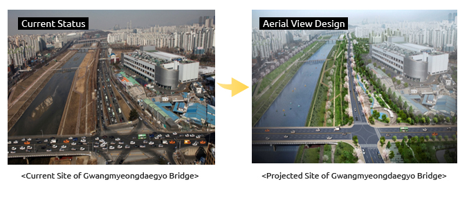


This clearly marks an improvement of the cityscape and quality of life in this part of the city, but not a disruption from the car-centric view. And don't expect to totally get rid of traffic noise: "vertical soundproof walls, currently installed between the Seobu Expressway and Gyeongbu Railroad Line, will be replaced with twice the amount of folded soundproof walls to reduce noise levels".

It may look a bit like Yangjaecheon, but a big part of this stretch is occupied by the Guro Digital Complex, not by mid-rise residences. In any case, good news for the district and for people working there. If sure the landowners in front of one of these crossings will find a better use of their ground levels...

Now if your start-up can't afford a Google-size campus for its staff, you can at least offer them a waterfront experience without the disgracious expressway a la Facebook (see "Zee Talk of Zee Town", "Google's Gtown wins over ZeeTown and the Large Apple Collider").


Seoul Village 2015
Welcome to our Korean Errlines! Follow Seoul Village on Facebook and Twitter
Bookmark and Share
Add this page to your favorites

* a Public Private Project on a Build Transfer Operate mode: "Seobu Underground Road To Be Constructed Through Private and Public Joint Agreement".

Wednesday, September 21, 2011

KTX coast to coast Incheon-Gangneung

It was part of the Pyeongchang 2018 bid but now that's official: the KTX Incheon airport line will be prolonged all the way to Gangneung by 2015, connecting key entry points (ICN, Seoul) to the future olympic venues and the East Sea. A major milestone for a national network in permanent development for conventional as well as high speed lines.

Historically, Korean railways followed the Seoul-Busan axis: the Gyeongbu Line and Jungang Line are basically Nortwest-Southeast parallels, the former starting from Seoul Station and the latter from Cheongnyangni (two multimodal hubs about to be more closely connected in the future).

The KTX dramatically shrunk distances, and now Daejeon competes with Daegu as the main hub between the capital and Busan because it lies at the intersection of the KTX Gyeongbu Line (Seoul-Busan 2h10)and the Honam Line (Seoul-Mokpo 1h46). Initially planned for 2014, Seoul-Gangneung is expected to take 1h39, largely within the goal set by railway authorities for all intra-korean lines (two hours maximum).

The Incheon Airport KTX line (not to be confused with the AREX - "
AREX on time for Seoul - Gimpo - Incheon" - even if it shares the infrastructure) reaches Wonju West station in Gangwon-do, with 5 stops in between:
- Susaek (Gyeongui Line, close to the DMC and Subway Line 6) in Susaek-dong, Eunpyeong-gu, Seoul
- Yongsan (other KTX lines, Jungang Line, and Subway Line 1) in Hangangno 3-ga, Yongsan-gu, Seoul
- Cheongnyangni (Jungang Line, Gyeongwon Line) in Jeonnong-dong, Dongdaemun-gu, Seoul
- Mangu (Gyeongchun Line, Jungang Line, Subway Line 1) in Sangbong-dong, Jungnang-gu, Seoul
- Yongmun (Jungang Line) in Yangpyeong-gun, Gyeonggi-do

The old Wonju Station being also on Jungang Line, this is basically an AREX-Jungang combo.

The Wonju-Gangneung extension will connect the two cities that gave their name to the Gangwon-do province when it was founded in 1395 (GANGneung + WONju = GANGWON). Wonju remained the capital for centuries but now Chuncheon rules: it claims 1.4 mn souls compared to 310,000 for Wonju and 230,000 for Gangneung.

Only two stops are scheduled between WON and GANG: Pyeongchang and Daegwallyeong, both in Pyeongchang-gun. Daegwallyeong is famous for the Daegwallyeong Sheep Farm, but two major olympic venues are located in this myeon: Alpensia and Yongpyong resorts.

When I think that driving to Yongpyong took us 6 hours back in 1992, if we were smart enough to leave Seoul before 6 AM to avoid the traffic on the old road... infrastructures have so much improved over the past two decades!

Well. Not all infrastructures proved successful. This new KTX line looks like another nail in Yangyang International Airport's coffin: that's by far the closest one to Pyeongchang as the crow flies, and it's quite ok (yours truly used it back in 2002), but it's a commercial flop and totally desert except for the occasional charter flight.

Even on steroids, a crow cannot beat a KTX.

Seoul Village 2011
NEW : follow Seoul Village on
Facebook and Twitter

Friday, March 26, 2010

Riverside bicycle road extended to Hanam

On March 31, the bike road following the Southern riverside of Hangang will by prolonged Eastwards by a new 13.5 km section, completing a 49.3 km-long Goyang*-Seoul-Hanam stretch.

The new section starts from Gwangnaru recreational park (광나루 유원지) in Gwangjin-gu, passes by Amsa-dong, Gangdong-gu (famous for its prehistoric site), and reaches the Paldang Bridge (팔당대교) in Hanam.

At that bridge, you are at the feet of two mountains : Duribong (566 m) in Hanam, and Yebongsan (679 m) in Namyangju on the other side of the river. So far, these hulky patches of green have kept urban development at bay, and I hope the Gwangju-Seongnam-Hanam merger** will not ruin this area.

From this new terminus, the bike lane may continue upstream towards the Paldan Dam and beyond Yangpyeong area, a very touristic spot. It could also connect to Namyangju city, right across the bridge.

But for the moment, Gyeonggi-do has already a lot of fish to fry. The province has invested KRW 70 bn in bicycle infrastructures since 2007, and 5 other projects are about to be completed, totalling 27.1 km :
. 5.6 km in Ansan : Sihwa Industrial Complex - Seonggok-dong
. 9 km in Gimpo : Han-gang New Town - Unyang Samgeori
. 2 km in Pyeongtaek : Songbuk-dong (Ojwa Samgeori) - Seojeong-dong (Bokchang Overpass)
. 6.5 km in Dongducheon : Bosan Station - Habongam-dong
. 4.0 km in Yeoncheon-gun : Dosin-ri (Sinseo-myeon) - Yeoncheon Bridge

Of course, Gyeonggi-do (over 10,000 square kilometers) will never have a network as dense as Seoul (605 sqkm, already 10 times more bicycle infrastructures), but that's a beginning.

Of course, this is by no means a network : Ansan is far (Southwest of Seoul) and Pyeongtaek even further. But the Gimpo New Town segment may eventually join the Goyang end of the Seoul lane... and with some imagination, the last two segments almost seem to be heading towards the Peace Bicycle Nuri Road** : the Jungnangcheon bike lane in Northeast Seoul already goes along Nowon-gu and towards Uijeongbu between Bukhansan and Seoraksan, why not continue in the same direction, straight to the North ? After Uijeongbu come Yangju, Dongducheon, Yeoncheon, Chorwon... and the DMZ.

Seoul Village 2010

* at Haengju Bridge (Deokyang-gu, Goyang-si, Gyeonggi-do)
** see "
Gwangju completes the Seongnam-Hanam merger"
*** "
Take a ride on the wild side"

Map : gg.go.kr (Gyeonggi-do's website)