NEW - download 'Seoul VillageS (서울 마을들)', my collection of 12 short fictions now adapted into short films! Get your free copy of the ebook (4 editions: English, French, Korean, Bilingual English-Korean)!

Showing posts with label Sajik-dan. Show all posts

Wednesday, January 26, 2022

More Gwanghwamun Square previews

Seoul revealed new visuals of Gwanghwamun Square 3.0, which shall be inaugurated in July.
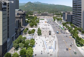
They prolong the last major iteration presented in 2019 ("Gwanghwamun Square 3.0 re-Deep-Surfaces"), which corrected one of the worst urbanistic blunders  of the initial version ("Gwanghwamun Square Enters Third Dimension"). PARK Won-soon's team rushed the construction a few months before the elections without conducting any decent impact survey, and work started late 2020. As soon as OH Se-hoon returned as mayor, he paused the site to assess the situation, but the changes could only be cosmetic.

The Woldae extension in front of the palace gate will only be created next year, so we have yet to see how vehicles flow around Yulgok-ro's future curve. Adjusting to the modifications already in place is not always easy. As expected, the intersection in front of Sajik-dan helps reconnect both sides of Sajik-dong, but the impossible new U-turn just North of the Government building stops functioning as soon as traffic slows down (too close before a major traffic light, unlike the old one heading for Sajik tunnel).

Most important, Seoul's defining axis is preserved, with its iconic Gwanghwamun-Gyeongbokgung-Bugaksan perspective, and pedestrians will enjoy a 20 m-wide park with a vast selection of tree species, guaranteeing natural shade and oxygen as they grow. That's where most of the extension (from 18 to 40,000 square meters) comes from. People will be able to sit on benches and along the Haechi Madang ramp, where street animations may bloom next to the new media wall.

Sejong-daero's pedestrian and cycling experience has already been improved with the new green walks and bike lanes added on the way to Namdaemun (see "Lower Sejongdaero's turn"). With its fountain tunnel and pavement fountain, the 'Gwanghwamun' Lounge section is likely to welcome kids and keep them fresh during the Summer. If some artifacts found during the renovation shall be on display in the cultural section, most of the Joseon era infrastructures (see timeline*) shall be covered again. I hope the tribute to Yukjo street will not look to corny. 


On the Eastern side, Junghak-dong will not host a simple reconstitution of the old Uijeongbu site, but a fusion hanok exhibition space. I wish there were more trees in that section, but that can (and probably will, if they want the spot to be successful) be fixed later.

This Uijeongbu project was on display at the Seoul Hall Of Urbanism (see again timeline below*) during the low key, pandemic-plagued 3rd edition of the Seoul Biennale of Architecture and Urbanism. SBAU will return in September 2023, with CHO Byung-soo (BCHO Architects) as its Director. This architects knows a bit about dao, and Seoul could do with some more harmony...

Ganghwamun Square reopening in the heat of the Summer will be a perfect crash test. I'm pretty sure Seoulites will quickly make it their own. At least during the evenings. And as much as that damned coronavirus will allow.


Seoul Village 2022
Welcome to our Korean Errlines! Follow Seoul Village on Facebook and Twitter, follow me on Instagram.
Download 'Seoul VillageS', the free ebook.

Bookmark and Share


* From @theSeoulVillage timeline: 


"Gwanghwamun Square last week. Seoul started controversial revamping without a proper impact survey..." (20201220 - twitter.com/theseoulvillage/status/1336888158437265408)


"The few changes since the initial plan won't prevent the expected traffic pandemonium. Tragic lack of urban planning, urbanism vision from Seoul... Sejong-daero Gwanghwamun" (20210221 - twitter.com/theseoulvillage/status/1364019424752115720)


"Western side of Sejong-daero / Gwanghwamun Square to close tomorrow for the controversial revamping (future Jeokseon-dong loop in the foreground)" (20210305 - twitter.com/theseoulvillage/status/1367760419218018306)

"As expected, works on the Western side of Gwanghwamun Square for its extension reveal Joseon time artifacts and structures related to former ministries. Here, a waterway in Jeokseon-dong (between Baekundongcheon & Junghakcheon - see seoulvillage.blogspot.com/2009/08/baekun #urbanism)." (20210319 - twitter.com/theseoulvillage/status/1372721209939431427)

"I guess mainly to evacuate overflows towards Baekundongcheon, to contain water damage in case of heavy rains. Gwanghwamun Square urbanism Jeokseon-dong Photo Chosun Ilbo" (20210319 - twitter.com/theseoulvillage/status/1372721211789037583)
"OH Se-hoon hits pause button on controversial Gwanghwamun Square revamping. Also asks AHN Cheol-soo to suggest talents for Seoul." (20210410 - twitter.com/theseoulvillage/status/1380664510638264322)


"Seoul's unearthed Yukjogeori during Gwanghwamun Square revamping:" (20210511 - twitter.com/theseoulvillage/status/1391895161337090049)


"Gwanghwamun's future Uijeongbu site at Seoul HOUR (Seoul Biennale / SBAU):" (20211028 - twitter.com/theseoulvillage/status/1453500318226935809)


Tuesday, April 10, 2018

Gwanghwamun Square Enters Third Dimension

Seoul Metropolitan Government and the Cultural Heritage Administration unveiled yesterday their plans for a 'New Gwanghwamun Square' by 2021, and they came up with a weird 'solution' for the potential traffic conundrum I mentioned four years ago, when the project started taking a clearer shape (see "Gwanghwamun, Donhwamun, and the Tale of two Royal Roads").


Gwanghwamun Square 3.0 - the royal Sejongno-Gwanghwamun-Gyeongbokgung-Cheong Wa Dae-Bugaksan-Bukhansan perspective

This modification of Seoul's most defining center has potentially even greater consequences than the previous one, which we followed step by step a decade ago. I will as usual focus on the urbanistic impacts (passing by many familiar spots), but since this is also about Korea's center of power ever since its capital was founded, I'd better start with some political context.


It's the politics, stupid?

Such a project deserves to be carried by both the local (SMG) and national (CHA) governments, and PARK Won-soon as well as MOON Jae-in happen to have a special bond with a site where PARK Geun-hye started and ended her presidency.

Started? If we all remember the massive, peaceful demonstrations that led to PGH's destitution, who could possibly forget that kitschissime wishtree** on Gwanghwamun Square, her first symbolic stop on her way to Cheong Wa Dae?

During his own campaign, MOON Jae-in pledged to move the presidential offices from Cheong Wa Dae to Sejongno, and the presidential residence closer to Gwanghwamun, in order to cleanse the feet of Bugaksan, and to honor the place where democracy took a stand and won. MOON also picked Gwanghwamun Square to celebrate his victory.

Retrospectively, I shudder when I remember AHN Hee-jung's over-the-top cheering that night - back then, I didn't know he couldn't even control his darkest pulsions... anyway, his DSK / #metoo moment completely revived the ambitions of a man who tried to steal the show on the very same night.

Only weeks ago, PARK Won-soon was clearly out of the game for the 2022 presidential elections, and about to be dumped by his own party for the upcoming mayoral elections (June 2018). Now he's leading the polls by far (against WOO Sang-ho and PARK Young-sun for the primaries, and against AHN Cheol-soo and KIM Moon-soo beyond), and this new project looks like the ideal platform for both ballots: he can make a splash in 2018 on the very site that boosted his predecessor's reelection***, and deliver the goods just months before 2022. Of course, PWS already combined a major urban project with a major political event before, but PGH's impeachment derailed Seoullo 7017's perfect timing ahead of the 2017 elections (see "Seoullo 7017, and more roads to Seoul").

Now is the right moment to communicate a grand scheme and vision, big enough to mask PARK's most recent shortcomings: he barely managed to avoid criticism for Seoul's waste management crisis by sending deputies to face the media, and he let his rival WOO preempt the usually well coveted 'public transportation' territory by campaigning on a new metropolitan authority, including yet another revival of the key Seobuseon project (after 2013, when "Seobu Line confirmed as Seoul's LRT top priority", the city dropped the ball once again).

So yes, it's about politics. But regardless of this context, Gwanghwamun Square and its surroundings needed a fix.


3.7 times bigger, 3.7 times better?

So what's the plan? Basically, the pedestrian zone grows not only, as expected, to the West and along nearby streets, but also right in front of the gate, making the road map much more complex, what I dubbed Seoul's 'Royal T'**** turning into a Y:


Seoul also revived its old ambition to restore Baekundongcheon, Cheonggyecheon's main source, the diagonal still visible on today's map (see "Baekundongcheon / Gwanghwamun-gil - A River Runs Through It"*****).

Seoul city advertises about the 3.7 factor by which pedestrian surface booms from 18,840 m2 to 69,300 m2, the reduction of traffic lanes to 6 along Sejong-daero, and its renewed demands to the State for a GTX extension to Gwanghwamun.

All this sounds very positive and environment friendly, but no really new green spaces are planned, and the extended square might make Summers and Winters even more merciless in what looks more like Tiananmen Square, or the barren landing site that preceded Yeouido Park.

There are still no dedicated lanes for buses or bicycles, and buses shall be redirected South, which seems recipe for disaster for public transportation around downtown Seoul, particularly since the new road map deprives Sajik-ro 8-gil (formerly Naejadong-gil) from its role of main NS/EW dispatcher.

Compared to Gwanghwamun 2.0, the 2009 revolution that brought pedestrians back to the heart of the capital, this Gwanghwamun 3.0 adds only marginal change to their experience. I like the idea of restoring the 'parvis' in front of Gwanghwamun, the Eastern pavillions and hanok around a 'History Square' that could liven up the walk from Seochon to Bukchon... but pushing traffic further downtown, and adding new bottlenecks to already saturated axes does seem like a big price to pay. 

Unfortunately, like with Seoullo, impact surveys have obviously been eluded in a race to meet electoral deadlines, and authorities chose to worsen traffic situations by not tackling them. Even the curve of the new road following the back of the central government building (that by the way shouldn't be on that History Square) tells about quick and dirty fixes without consideration for the big picture.

What Seoul needed was a consistent vision and plan to prepare its whole historic center Sadeamun (intra muros) for a driverless future. What Seoul delivered was a dangerously incomplete, short-sighted, ill-prepared PR stunt.

The city will take one year to select a proposal, start work in January 2020, and finish by EOY 2021. Mayor PARK missed by a few months last time, and 2021 seems safe enough a goal for him to inauguration the new (if not improved) Gwanghwamun Square. 

I sincerely hope he'll reconsider this plan, and grow some ambition for our city.

Seoul Village 2018
Welcome to our Korean Errlines! Follow Seoul Village on Facebook and Twitter
Bookmark and Share
Add this page to your favorites

* see "The Anipang Election: Park wins big, but who won?"
** see "Park 2 Day 1 in pictures"
*** will OH Se-hoon rise again (on billboards, at least - see "OH Se-hoon returns... but did he ever leave?")
**** see "Inwangsan's Great Wall and Seoul's Royal "T" Time"
***** note that since my 2009 focus, the streets West of Sejong-daero have been renamed Saemunan-ro 9-gil and Saemunan-ro 5ga-gil. Seoul also renewed the project of highlighting walls around Sajik-dan and Sajik-park.

Tuesday, April 12, 2016

The Yongsan itch and the Sajik balm

One up, one down. Seoul speeds up for the redevelopment of Yongsan 4, and puts the brakes on Sajik 2.

We've known for a while* that the future Yongsan Park would be surrounded by high rise structures. After burning their fingers on the doomed Yongsan IBD project, authorities decided to offer their all-you-can-build gifts to speculators in smaller packages, wrapped in green. Here, at the Hangangdae-ro - Seobinggo-ro interesection (Hangangno-dong), a tentative 'Yongsan Parkway' serves as an environmental alibi for more 30-40+ towers:


In Jongno-gu, a far less popular - and far less tragical** - "drama" has also been running for years: the redevelopment of what I call Sajik Heights, the hilly neighborhood nested between Sajik-ro / Sajik Tunnel, Space Bon, and Gyeonghuigung. I've walked its alleyways countless times, and even wrote a short story about Kim Ki-chan meeting my fictional Kim Mudangnim there (the great photographer also used to live in Sajik-dong).


A pigeon, a hanok, a hilly alleyway, Inwangsan - Sajik Heights in 2009

For a decade, Sajik Heights has been preparing for the transformation, and Lotte Castle eventually won the right to build the New Town.


As far as 'urban continuity' goes, it looked consistent with the Gyeonghuigung Xii (Gyonam New Town) rising from the other side of the tunnel / hill / (now almost totally obliterated) fortress wall... 

But Seoul city seized a debate over modifications to stop the process***. Among the landmarks to be protected (let's hope in a less destructive way than nearby Dilkusha****), the 1906 house where Josephine Eaton Peel Campbell lived. I visited that place at the top of the hill, around the time it was used as an office by local residents. It seems to have never been used for the purpose the Campbell estate sold it, which was to promote the education of young girls, in the tradition of Campbell herself, the founder of Baehwa (girls' schools and women's university in Pirun-dong).

Residents are now wondering what's best for them, particularly after witnessing what happened in the vicinity: Gyonam? newtonized. Seochon? bukchonized. So what for Sajikistan?

Whatever happens in the future, something of the old neighborhood shall survive. Or evolve. 

Anyway, it would be nice to see something decent next to a potential UNESCO Heritage site (Yeol still working hard on the Sajik-dan revival*****).

Seoul Village 2016
Welcome to our Korean Errlines! Follow Seoul Village on Facebook and Twitter
Bookmark and Share
Add this page to your favorites
.
* see for instance "Yongsan park - fake forests and real estates" (Feb. 2011)
** if a person died in Yongsan, no casualties for the only tragedy I witnessed when I lived in Sajik-dong, a hanok fire back in 2009.
*** "사직2구역 재개발 추진 7년…110년 된 캠벨 사택 어쩌나" (JoongAng Ilbo 20160413)
**** less forsaken than 5 year ago (see "Sajik Heights and micro-hanokization"), the building seems to have undergone serious change in the name of 'preservation' 
***** rites have been performed for a long while, and the restoration helped as well (see "Sajik-dan enshrined, Naeja-dong revived ?")

Saturday, March 23, 2013

Old Seoul, Old Seochon

donA just published the first volume of a history of Seoul written by Professor CHOI Jong-hyun (Hanyang University Urban Planning and Engineering) and KIM Chang-hui (dongA Ilbo), centered as it should be around my favorite Seoul neighborhood: Seochon - Inwangsan - Gyeongbokgung - Sajik-dan... Volume 2 will lead us towards the East (Dongdaemun) and Southeast (Gwanghuimun), and volume 3 along Cheonggyecheon and other parts of Jongno.

The book is said to be very lively, and to make you feel as if you roamed the alleyways of old Seoul, like in "Les Miserables". And you know how I feel for Seoul alleyways*!

I can't wait to read it, and I hope the book will soon be available in English. Why not in French (personal message to French readers who love Seoul and work in / study / teach urbanism)?


Old Seoul / "오래된 서울"
Written by Choi Jong-hyun and Kim Chang-hui
364 pages, dongA publications
ISBN-10: 8996787221 - ISBN-13: 9788996787228


Seoul Village 2013
Welcome to our Korean Errlines! Follow Seoul Village on Facebook and Twitter
Bookmark and Share
Add this page to your favorites

* "Seoul needs alleyways. By "alleyways", I don't necessarily mean the last capillaries irrigating the actual "Seoul Intra Muros" ("Sadaemun", the original city surrounded by its fortress), but also the kind of inclusions that extend Seoul, the places where the city can freely and randomly stretch, grow more complex, and reach deeper, these intimate scars where your own mind can't help but wander." ("Magok District: SIM City as in "Seoul Intra Muros"? Alleyways as in "Seoul Inter Muros"?"). PS: I just finished a short story about alleyways for my collection of fictions devoted to Seoul...

Monday, September 5, 2011

Sajik Heights and micro-hanokization

My previous post* reminds me I forgot to mention an interesting development over Sajik Tunnel : this new hanok overlooking the traffic.


I waited to have the photo opportunity as a car passenger to show the impact from Sajikno. Of course, what strikes you first is the very ugly Yangeuimun Church, a towering white monster under wraps these days (maybe to transform into a towering colorful monster). The red bar to its right is the Korea Social Science Data Archive (KOSSDA or 한국 사회과학자료원). Further to the right is the Jongno Culture and Sports Center, where I used to go swimming twice a week or so**. And to reach this place from Gwanghwamun Space Bon, I had to pass in front of that hanok spot so I know pretty well every inch along the way.

I could write stories about the alleyway leading up to what I call Sajik Heights from Sajikno, the pawprints left by a dog on the rough concrete staircase, the passage over Sajik Tunnel (now covered with a deck), and the poor white dog who broke my heart each time I passed by her tiny place : either leashed or in her small cage, the poor bitch ruled over a 10 square feet staircase (she managed to get babies once but didn't keep them for long).

Now about this new hanok. There's a bigger one behind, and the owner used to grow an amazing variety veggetables in front of his place, including where this small new extension stands, by the ruins of a house partly serving as a parking lot.

This is a truly minor change, and there are many other hanoks nearby, and more than a few nice "jutaek" on the way to Sajik-dan and Seochon, but this tiny detail could have a lot of significance for the local urban landscape because of its visibility for outsiders at a key location.

I'm not talking about something very spectacular like the restoration of a whole traditional village, but about a small protuberance that catches the corner of your eye and suddenly connects you to a neighborhood, help you reconcile with your city. So many places disappeared over the years, and particularly along major avenues, that it's hard to get a notion of what's been lost without venturing deeper into vernacular Seoul. But from time to time, hope shyly shows its head.

Of course, preserving existing landmarks remains preferable to artificially creating new ones. And right on the other side of the tunnel (in Haengchon-dong, 1-88 beonji), there's an amazing jewel on the verge of collapse : not far from a magnificent gingko tree, this 1923 red brick house is not abandoned but - to say the least - poorly tended. Named Dilkusha ('my heart is happy' in Hindi), it used to be the residence of Albert Taylor, the press correspondant who was jailed for 6 months in Seodaemun Prison - at the 2009 exhibition "Three Foreigners' Reminiscence of Seoul" at Seoul Museum of History two years ago, they mentioned how his wife Mary could see him, from their house, walk the prisoners walk.

At the time of its construction, the view over the valley must have been breathtaking but now, villas almost completely occult it. I hope it can be saved the way a smaller red brick landmark was, just one block away : it is now a mini-museum at the corner of the park recently created at the top of the future Gyonam / Dongnimmun New Town.

We also owe Taylor the
fantastic panorama exhibited on the museum's ground floor (curators had the brilliant idea to match this 90 year old marvel with a contemporary view of downtown Seoul).

Seoul Village 2011
NEW : follow Seoul Village on
Facebook and Twitter

* "
Junggye's "Baeksa Village" shall survive"
** or picknicking higher on Inwangsan (follow the trail on "
Inwangsan's Great Wall and Seoul's Royal "T" Time")

Thursday, April 21, 2011

Seochon, Sejong Village, or what ?

Now officially protected from reckless redevelopment, Seochon area is preparing for its cultural rebirth. All the ingredients are there, but a marketing battle seems to be brewing over the brand. How to name the place ?

"Seochon" echoes the village West of the Gyeongbokgung, an axis we've already discussed and a waterway about to be reopened. There could be some confusion with Seocheon-gun in Chungnam, and some confusion with Bukchon : Seo means West and Buk North, but "cheon" means stream and "chon" village.

Like Gahoe-dong on the other side of the royal palace, it would be unfair to pick a dong name out of the hat : the 600 hanoks are scattered across a dozen neighborhoods, each one with its own characteristics (Naeja-dong, Chebu-dong, Nuha-dong, Nusang-dong, Pilun-dong, Ogin-dong, Tongin-dong, Hyoja-dong, Changsang-dong, Tongui-dong...).

I often refer to the area as "Chebu-dong" because that's the central dong, but that's wrong. Technically, most neighborhoods belong to the two "administrative dongs" of Sajik-dong and Hyoja-dong, the former being maybe more suitable since it's associated with a major royal site (Sajik-dan), and a clear destination West of the Gyeongbokgung. Hyoja-dong touches the palace walls, and is more associated with the North and the presidential palace (even if Cheong Wa Dae belongs to Sejongno-dong and the administrative dong of Cheongun-dong).

Recently, some residents have been pushing a "Sejong Maeul / Sejong Village" label, probably because King Sejong was born there : a plate commemorates the location of the hut where the great man was delivered, following the tradition depicted at the nearby National Palace Museum of Korea. But I'm not sure the commoditization of the Sejong brand is such a good idea : this "Sejong Village" sounds like an annex to Sejongno, not a place with its own identity.

Since the whole area grew along the branches of the soon to be reborn stream, why not stick to Seochon ?

Seoul Village 2011

see other Seochon related posts, including "Stop The Hanok Genocide... And Stop Revival As Reenactment" and "Baekundongcheon / Gwanghwamun-gil - A River Runs Through It"

Monday, September 6, 2010

Reconsidering Sejongno Park

After the Eastern side of Sejongno this morning ("Insadong - Bukchon seamless for pedestrians"), some news from the not so far West.

At the intersection between Naejadong-gil* and Sejongno lies a small public park echoing the historical significance of the area, for centuries a cluster of ministries. But Sejongno Park is neither nice nor welcoming, and most visitors are simply on their way in or out the old parking operated underground. I often wonder how Sejongno would look like if it were animated all the way during cultural events, and particularly if this very spot were better designed : here is a very large space, in an ideal location (between Gyeongbokgung, Gwanghwamun Square, and Sejong Cultural Center), but totally wasted.


That could be about to change : the contract with the tenant expires in 2012 and the city intends to revive the area, creating a sunken garden, also history-themed, which (I presume) could be connected to the existing underground walkway across the boulevard, and maybe even to the King Sejong exhibition space inaugurated last year under Gwanghwamun Plaza.

That would make not only perfect sense but confirm the success of the restoration of Seoul's most prestigious axis. Of course, the design had better be right from the start (please not another Haechi Madang, please not another dangerous staircase that visitors discover only a split second before breaking their own necks...).

I reckon authorities will also keep an eye on demonstrators : since Gwanghwamun Square inauguration, small political gatherings have regularly been using the Cultural Center's staircases as a tribune, and this new spot would be almost at the feet of the Central Government Building... Note that further down the boulevard (Taepyeongno will merge with Sejongno), Mayor OH Se-hoon is facing similar threats : the metropolitan assembly, now overwhelmingly progressive, voted in favor of facilitating demonstrations under his very windows on Seoul Plaza.

More animation ahead, then. And many colorful "events" (pronounce "eee-bent").

Seoul Village 2010

* If you're not familiar with Naejadong-gil, that's the street perpendicular to the boulevard, starting between Sejong Cultural Center and the Central Government Building, with a short tunnel connection to the other side of Sejongno (near the US Embassy), and leading to Sajikno in front of Sajik-dan, with Inwangsan in the background. The street progressively evolves from an administrative / office center to a residential hub (Gwanghwamun Space Bon, Gyeonghuigungoe Achim...), with the Seoul Metropolitan Police in the middle and many eateries.

---
UPDATE 20110524 - Sejongno Park under renovation
---

Wednesday, June 30, 2010

Gwanghwamun restoration : too bballi-bballi ?

The other day*, I mentioned the acceleration of operations at the Gwanghwamun renovation site.

It was not just an impression : the Korean Government wants the work to be completed by the end of July ! It already pushed for an inauguration ahead of the November G20 meeting, but now the concept is to be ready for August 15 / 8.15, Korea's Independence Day.

Fine, but we're not just talking about a yearly event, here : just like Sungnyemun, this gate was supposed to be rebuilt by scrupulously respecting traditional methods. Time was of the essence, but in a Confucian meaning, not the "빨리빨리" way.

Try to explain that to a self-proclaimed "Bulldozer"...

Seoul Village 2010

* "
Jongno-gu renovation - continued" - as a matter of fact, the finition of the walls around Sajik-dan took much more time

Friday, April 2, 2010

Sajik-dan enshrined, Naeja-dong revived ?

Scaffolding off, Sajik Park exposes its newly restored wall : the traditional stone, wood, and tile construction protects Sajik-dan more efficiently and elegantly than the awful iron fence that used to welcome visitors to that prestigious shrine, the pendant to Jongmyo West of Gyeongbokgung*.

Now Hongsalmun looks again like a gate and not just an isolated monument. And the rites performed in Sajik-dan move closer to their recognition as a UNESCO World Heritage.

This restoration also paves the way for the great Jongno-gu project to redesign the historic Yulgokno-Sajikno axis. I guess it will include traffic lights with pedestrian crossings somewhere between Medong-gil / Pilundae-gil and Naejadong-gil, as well as (speaking of paving the way) decent sidewalks on both sides of Sajikno along Naeja-dong : removing the overpass was a nice first step, but you get tired of potholes.

The Southern half of Naeja-dong is about to change too, and I hope for the better. A first meeting was held last month between residents and local authorities, generally the initial stage for redevelopment, but new regulations also confirmed the protection of hanoks and this area has quite a few to save. The Western part is occupied by the massive headquarters of Seoul Metropolitan Police and at the other end there's a big officetel (Blois), a church, and a collection of medium-sized buildings. In between, an intricate network of small streets full of hanoks, most of them restaurants, marked by Jangchunggo-gil : the only street cutting fully the block between Sajikno and Naejadong-gil is slightly curvy and hilly, and most houses on the Eastern side are traditional ones, which gives it an interesting charm and potential. I often wonder how it would look if both sides were "rehanokized". It would not only save the existing cluster, but also create a very interesting touristic and gastronomic spot opposite Chebu-dong and on the way to Sajik-dan or Sungok Art Museum.

Furthermore, it would also make sense from an historical point of view : this is precisely the place where all the catering was prepared for festivities at the Gyeonbokgung, between the palace and the shrine celebrating harvests and food.


Seoul Village 2010

* "Inwangsan's Great Wall and Seoul's Royal "T" Time". We already mentioned the restoration of this wall (see "The Sandwich").

see other Seochon related posts, including "Baekundongcheon / Gwanghwamun-gil - A River Runs Through It"

Tuesday, July 28, 2009

The Sandwich

The Space Bon terrace, where Naejadong-gil meets Sajikno, is getting more crowded.

Starbucks Cafe, the small convenience store, and nearby Cafe Mori have been recently joined by new cafes, snacks and restaurants : seafood (Gorebul), Japanese (Koen), tea (Puer)... and my new "cantine" when I need a tasty burger.

"The Sandwich" prepares burgers, salads, soups and (of course) sandwiches with good ingredients, terrific bread, and original sauces. You'll find East Coast classics (BLT, Philly, submarine, French fries, breakfast...), experience some innovations (ie interesting sauce with salmon sandwich), and even eat healthy and tasty veggies... though I must confess I have a weakness for their chilly burger (to die for).

It's a small place with a small kitchen, and they're often full for lunch. Those in a hurry may prefer to avoid rush hours (12 to 1).

If you manage to get a seat on the terrace (each restaurant seems to be allowed only two outdoor tables), it can be an interesting spot for the summer. The block protects you from the sun for lunch, and a small garden provides some fresh air... with the contribution of the mountain : the view on Inwangsan comes as a bonus, with Sajik Park and Hongsalmun at its feet*, and often spectacular summer skies for sunset.

The Sandwich (restaurant)
Gwanghwamun Space Bon 201-107 B
9 Sajik-dong, Jongno-gu, Seoul, ROK 110-054
Tel: +82.2.720.9396


Seoul Village 2009

* see "
Inwangsan's Great Wall". Note that Sajik-dan will be protected by a new traditional wall - old rites are being performed regularly and I suspect authorities to push for a UNESCO heritage listing.

Sunday, March 29, 2009

Inwangsan's Great Wall and Seoul's Royal "T" Time

Seoul mountains represent a unique feature for a major metropolis. Even from downtown, you can enjoy great daylong walks across picturesque sceneries.

If you think traditional paintings of royal palaces look too stylized to be true, just take a two-hour hike up Mount Inwang (Inwangsan) and along its fortress walls, and enjoy the best view over Seochon, the Gyeongbokgung, Cheong Wa Dae, the city center and Namsan. As you rise, parts of Gangnam and such landmarks as the COEX or the 63 Tower join the party in a memorable panorama.


Let's zoom out for a minute or two. I've been following very closely the dramatic changes under way in the heart of Seoul and particularily around its main axis Sejongno. If you consider the "T" leading to the Gyeongbok Palace, the upper bar doesn't look as nice as it should since both sides lead to ancient royal shrines. But change is coming.

The Eastern part, Yulgokno, can leverage on major assets : the Anguk hub linking two touristic areas (Insadong and Gahoe / Bukchon, both expanding), and soon to be re-connected UNESCO World Heritage twins (see "Jongmyo-Changdeokgung reunited"). Much has already been done and who knows, some day, Seoul city shall also decide to remove the two miserable gas stations guarding the beautiful entrance of the Changdeok Palace...

The Western bar of the "T" draws much fewer tourists, but hides different kind of treasures. Sajikno leads to Seodaemun and Dongnimmun, but both lie on the other side of the Sajik Tunnel. And synergies between Sajik Park and Gyeonghuigung are limited until a much needed Northern entrance to the Gyeonghui Park is opened*...

On the other hand, today's shortest way (cutting through Shinmun-ro 2 Ga - the double street called Gyeonghuigung-gil) is full of art galleries, nice cafes and fine restaurants, and it will drop you at the feet of the Seoul Museum of Art... Speaking of which : Tongui-dong is welcoming a growing number of art galleries and decent eateries. Seochon is not Sogyeok-dong yet, but at last there is some echo this side of the Gyeongbokgung walls...

The past few months have seen dramatic changes along Sajikno. Just last month, a derelict pedestrian overpass connecting both sides of Naeja-dong has been removed, and soon, a crossing shall dramatically shorten the walking distance between Gyeongbokgung Station and Sajik Park... which is itself undergoing a spectacular lifting : exit the giant concrete platform, enter a new gentle slope towards Inwangsan-gil and the mountain.

Marked by Hongsalmun (홍살문), the gate of Sajik-dan (사직단), Sajik Park itself may not look very spectacular right know, but it does hold a special significance (as fundamental as Jongmyo and Gyeongbokgung for the King) and host many cultural events, most notably the traditional rites at Sajik-dan and Ye-dan. The small squares where almost shamanic rites were performed in favor of food and agriculture stretch peacefully without really leaving ground. And neither Hwanghakjeong (archery pavillion) nor Tangun Shrine (devoted to the mythical founder of the nation), both behind the park, open their gates every day to the public.


ALL ALONG THE WATCHTOWER

Just meters away from the shrine, the hulk of Jongno-gu's Cultural and Sports Center can help locate the beginning of the Inwangsan fortress walls. Considering the clearing being prepared just across the street, I guess a more specific building shall welcome hikers and tourists in a not too distant future.

For the moment, the most convenient landmark is this shanty drugstore one block away from the Cultural Center.

Behold, You Who Cometh to Ascend the Great Wall : as I write these lines (this may change soon), this ruin happens to be your last chance to purchase a snack or a bottle of water, and the Center your last opportunity to empty your bladder indoor. On the way up, no facilities can be found except a few trashcans, and a couple of army sentry boxes.

Note that you are entering a formerly restricted area overlooking the Blue House and sensitive bases. The Inwangsan park was closed after the 1968 assassination attempt of Park Chung-hee by a North Korean commando, and reopened in 1993. Taking pictures of Cheong Wa Dae, littering the place, or firing a missile on the Government's HQ are stricly forbidden.

The first portion of the ascension remains a civilian area, and is turning into a pleasant neighborhood park, with a small wooden platform overlooking the city. Here, the XVth century wall separates Sajik-dong from Muak-dong. It goes all the way up to the summit, and its restoration is now almost completed ; higher up, you can see a temporary rail running along it, probably to carry the heavy concrete stones.

This part was restored earlier, and the Gu is now focusing on making the place an ideal place for families to rest or picnic. Gardeners are cleaning the bushes, planting new trees, and removing most weeds or detritus. Unfortunately, the authorities, felt compelled to add the usual gym equipments, and I'm afraid I know where they plan to install them : the small wooden platform may become a large concrete terrace, ruining the charm of one of the cutest spots.

These days all trees are blooming, and later in the year, you can pick apricots while strolling. But March-April has its advantages, particularily since the view isn't blocked by vegetation.

I was surprised to see many families with very young children go all the way up, which includes a vertiginous walk on a rock at the top, and the second section of the ascension, marked by a grilled gate leading to a narrow and steep staircase (the only unpleasant part of the journey, and it doesn't last long).

The third section leads to the granite top of the hill, along the serpentine wall and a not too demanding slope. To the left, the view improves from apartment buildings to Inwangsa, and then to a pine forest. To the right, Bukhansan's majesty becomes clearer as the vegetation grows thicker. Behind you, Seoul keeps revealing itself step by step.

From the rock, next to an army barack, you can see Gangnam even behind Namsan (274.5 m high, compared to 338.2 for Inwangsan). This is the intersection of Muak-dong to the South, Hongje-4-dong to the West and Nusang-dong to the East. It could be the perfect spot to finish the ascension but then, just on the other side of the rock, you discover the fourth section : a welcoming clear path leading to the round dome of Bukhansan.

The beauty of this hike that at each station, you can either enjoy the view and call it a beautiful day, or venture one step beyond.

Seoul Village

* the Southern flank of the park is getting ready for Gyonam New Town : the block of small restaurants separating the Gangbuk Samsung Hospital and the Gyeonghuigung entrance will be replaced by a public garden, which has already been partly opened along the newly restored wall.